1960s Maps of Hamilton County, Ohio
Explore 12 historic maps of Hamilton County from the 1960s. These maps offer a rare glimpse into what life looked like during the 1960s — showing old roads, neighborhoods, homes, and landmarks that have changed or disappeared over time.
Whether you're researching your family's past, planning a metal detecting trip, or studying how Hamilton County's landscape evolved across the 1960s, these high-resolution maps are a powerful tool for exploring the history of this region.
- Focus on a specific era: All maps on this page are from the 1960s, giving you a focused view of this time period.
- See what’s changed: Compare century-old streets, trails, and buildings to today's modern landscape using overlays and satellite layers.
- Research with precision: Use these maps for genealogy, historical research, land use analysis, or educational projects.
- View, download, or print: Maps are fully viewable online in high resolution, and can be downloaded or printed for your own records.
Start exploring Hamilton County's history through authentic maps from the 1960s. This is your window into the past.
Hamilton County, OH maps
(12)- 1960 Map of Addyston, 1963 Print
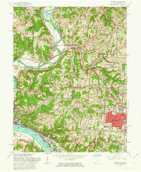 1960 Addyston1963 Print · USGSGreater Cincinnati's western riverfront is captured here in the early sixties, showing the industrial pulse of Addyston and North Bend along the river. Genealogists can trace family names at the Bridgetown Cemetery or locate schools like Oak Hill High Sch.3 unique versions available
 - 1961 Map of Cincinnati West, 1963 Print
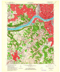
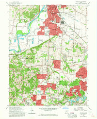
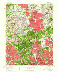 1961 Cincinnati West1963 Print · USGSGreater Cincinnati was rapidly expanding into northern Hamilton County in the early sixties as new subdivisions began to fill the valleys. Genealogists and historians can locate numerous landmarks like Arlington Memorial Gardens Cemetery, St Josephs Orphanage, and the grounds of McAuley High Sch.6 unique versions available
 - 1961 Map of Madeira, 1963 Print
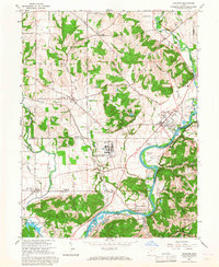
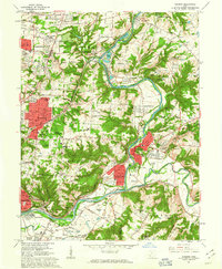 1961 Madeira1963 Print · USGSThe Little Miami valley was transitioning into a suburban corridor in the early sixties as riverfront industry met growing residential estates. Genealogists can trace family names through Evergreen Cem and United Cem, or locate landmarks like the Sacred Heart Novitiate and Cincinnati Country Day School.5 unique versions available
 - 1961 Map of Burlington, 1963 Print
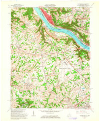 1961 Burlington1963 Print · USGSNorthern Kentucky and the Cincinnati riverfront meet in the early sixties during a period of rapid suburban and industrial growth. Genealogists and local historians can trace family burial sites like the Col Abraham Depew Grave and river crossings like the Anderson Ferry.3 unique versions available
 - 1961 Map of Covington, 1963 Print
 1961 Covington1963 Print · USGSThe Ohio River corridor comes alive in the early sixties as industrial centers and hillside neighborhoods bridge the state line. Genealogists and historians can trace St Josephs Cemetery, find the St Johns Orphanage, or locate the Anderson Ferry crossing.3 unique versions available
 - 1961 Map of Newport, 1963 Print
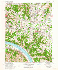
 1961 Newport1963 Print · USGSGreater Cincinnati and Northern Kentucky were entering a period of suburban maturation in the early sixties as riverfront industry met rising hilltop neighborhoods. Researchers can trace local landmarks like Coney Island Amusement Park, Evergreen Cemetery, and the VA Hospital at Fort Thomas.3 unique versions available
 - 1961 Map of Cincinnati East, 1963 Print
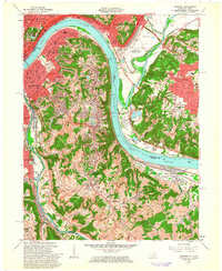
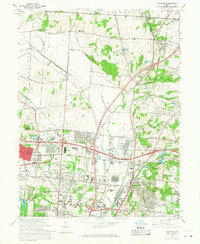
 1961 Cincinnati East1963 Print · USGSGreater Cincinnati was entering a period of significant suburban expansion in the early sixties as industrial valleys met growing residential tracts. Researchers can trace family roots through numerous parish schools and sites like St Marys Cemetery, the University of Cincinnati Observatory, and the Baltimore and Ohio Railroad lines.6 unique versions available
 - 1961 Map of Withamsville, 1963 Print
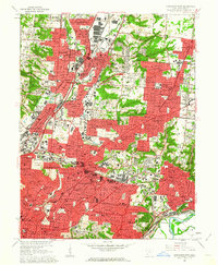
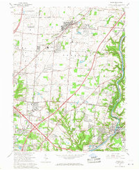
 1961 Withamsville1963 Print · USGSGreater Cincinnati was expanding rapidly during the early sixties, as suburban estates began to fill the heights above the river. Researchers can trace the development of Withamsville and Melbourne, find local landmarks like St Gregory Seminary, and locate the old Drive-in Theater.3 unique versions available
 - 1965 Map of Greenhills, 1968 Print
 1965 Greenhills1968 Print · USGSGreater Cincinnati's northern suburbs were rapidly evolving in the mid-sixties as post-war growth transformed the Butler and Hamilton County line. Genealogists and local historians can trace family-named sites like Huston Cem and landmarks such as St Francis Seminary and Lake Gloria.4 unique versions available
 - 1965 Map of Shandon, 1968 Print
 1965 Shandon1968 Print · USGSThe Butler and Hamilton County borderlands were defined in the mid-1960s by a unique mix of industrial facilities and deep-rooted rural settlements. Genealogists can trace family landmarks like Shaker Cem and Scott Cem or locate the sprawling U S Reservation (Atomic Energy Commission) facility at Fernald.3 unique versions available
 - 1965 Map of Glendale, 1968 Print
 1965 Glendale1968 Print · USGSThe northern Cincinnati suburbs and Butler County borderlands were rapidly modernizing in the mid-sixties as highways met historic rail junctions. Genealogists and local historians can trace family plots at Oak Hill Cemetery and locate older rail-stop communities like Rialto, Port Union, and West Chester Sta.4 unique versions available
 - 1965 Map of Mason, 1968 Print
 1965 Mason1968 Print · USGSWarren and Hamilton counties are shown in the mid-sixties as the suburban corridor north of Cincinnati began to accelerate. Researchers can trace the massive U S Reservation Voice of America site, the old crossroads at Sixteen Mile Stand, and landmarks like the Radio Tower (WLW).4 unique versions available
End of results
Showing maps 1-12 of 12
Top cities of Hamilton County
- Cincinnati historical maps
- Norwood historical maps
- Forest Park historical maps
- Sharonville historical maps
- Blue Ash historical maps
- Springdale historical maps
See more
Frequently asked questions
- What are the different types of historical maps available for Hamilton County?
- What is the oldest map of Hamilton County?
- Where can I purchase historical maps of Hamilton County for my home or office?
- Where can I download high-res historical maps of Hamilton County?
- Are there historical topographic maps available for Hamilton County?
- Is there historical aerial imagery available for Hamilton County?
- Where are historical maps of Hamilton County sourced from?