1990s Maps of Hamilton County, Ohio
Explore 7 historic maps of Hamilton County from the 1990s. These maps offer a rare glimpse into what life looked like during the 1990s — showing old roads, neighborhoods, homes, and landmarks that have changed or disappeared over time.
Whether you're researching your family's past, planning a metal detecting trip, or studying how Hamilton County's landscape evolved across the 1990s, these high-resolution maps are a powerful tool for exploring the history of this region.
- Focus on a specific era: All maps on this page are from the 1990s, giving you a focused view of this time period.
- See what’s changed: Compare century-old streets, trails, and buildings to today's modern landscape using overlays and satellite layers.
- Research with precision: Use these maps for genealogy, historical research, land use analysis, or educational projects.
- View, download, or print: Maps are fully viewable online in high resolution, and can be downloaded or printed for your own records.
Start exploring Hamilton County's history through authentic maps from the 1990s. This is your window into the past.
Hamilton County, OH maps
(7)- 1992 Map of Hooven, 1995 Print
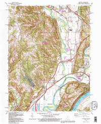 1992 Hooven1995 Print · USGSThe convergence of the Ohio and Great Miami Rivers defines this tri-state borderland during the late twentieth century. Researchers can trace historic riverfront settlements and burial sites like Elizabethtown, North Bend, and the Harrison Tomb State Memorial.
 - 1992 Map of Harrison, 1995 Print
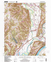
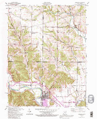 1992 Harrison1995 Print · USGSThe Ohio-Indiana borderlands come alive in the early nineties as the communities of Harrison and West Harrison grow along the Whitewater River. Researchers can trace rural school sites like Township Sch and family burial grounds including Snow Cem and Braysville Cem.
 - 1996 Map of Addyston, 1999 Print
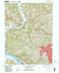 1996 Addyston1999 Print · USGSThe Great Miami and Ohio River valleys show a mix of industrial riverfront and growing suburban centers in the 1990s. Trace local landmarks like the Miamitown Airport, Miami Cem, and the CSX rail corridor as it winds through North Bend and Addyston.
 - 1996 Map of Madeira, 1999 Print
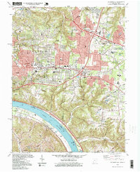
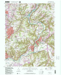 1996 Madeira1999 Print · USGSThe Little Miami River valley in the late nineties shows a landscape of established suburban communities and scenic river corridors. Trace family roots and local history through landmarks like Armstrong Chapel, Hopewell Cem, and Camp Dennison.
 - 1996 Map of Hooven, 1999 Print
 1996 Hooven1999 Print · USGSThe convergence of the Ohio and Great Miami Rivers in the late 1990s reveals a landscape of industrial river junctions and presidential history. Genealogists and historians can trace rail paths through Valley Junction or visit the Harrison Tomb State Memorial and Sugar Ridge Cem.
 - 1996 Map of Withamsvile, 1999 Print
 1996 Withamsvile1999 Print · USGSThe Ohio River valley and its growing suburban townships are captured here in the late 1990s as modern development reaches historical settlements. Researchers can trace the layout of St Gregorys Seminary, the Guardian Angel Cem, and the riverfront at Melbourne.
 - 1996 Map of Harrison, 1999 Print
 1996 Harrison1999 Print · USGSThe border country of Ohio and Indiana comes alive in this survey, centering on the river towns and rural townships during the late nineties. Genealogists and local historians can trace family plots at Snow Cem, locate the old Township Sch, or find the historic Covered Bridge spanning the Johnson Fork.
End of results
Showing maps 1-7 of 7
Top cities of Hamilton County
- Cincinnati historical maps
- Norwood historical maps
- Forest Park historical maps
- Sharonville historical maps
- Blue Ash historical maps
- Springdale historical maps
See more
Frequently asked questions
- What are the different types of historical maps available for Hamilton County?
- What is the oldest map of Hamilton County?
- Where can I purchase historical maps of Hamilton County for my home or office?
- Where can I download high-res historical maps of Hamilton County?
- Are there historical topographic maps available for Hamilton County?
- Is there historical aerial imagery available for Hamilton County?
- Where are historical maps of Hamilton County sourced from?