1900-1909 Maps of Harrison County, Ohio
Explore 9 historic maps of Harrison County from 1900-1909. These maps offer a rare glimpse into what life looked like during the 1900s — showing old roads, neighborhoods, homes, and landmarks that have changed or disappeared over time.
Whether you're researching your family's past, planning a metal detecting trip, or studying how Harrison County's landscape evolved across the 1900s, these high-resolution maps are a powerful tool for exploring the history of this region.
- Focus on a specific era: All maps on this page are from the 1900s, giving you a focused view of this time period.
- See what’s changed: Compare century-old streets, trails, and buildings to today's modern landscape using overlays and satellite layers.
- Research with precision: Use these maps for genealogy, historical research, land use analysis, or educational projects.
- View, download, or print: Maps are fully viewable online in high resolution, and can be downloaded or printed for your own records.
Start exploring Harrison County's history through authentic maps from the 1900s. This is your window into the past.
Harrison County, OH maps
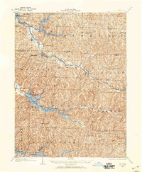
(9)- 1901 Map of Cadiz, 1954 Print
 1901 Cadiz1954 Print · USGSEastern Ohio at the dawn of the twentieth century was a landscape of ridge-top villages and bustling rail junctions. Trace the steam-era connections between Cadiz Junc and Jewett, or locate historic settlements like Bloomingdale and Amsterdam.2 unique versions available
 - 1902 Map of Scio, 1959 Print
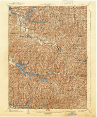
 1902 Scio1959 Print · USGSHarrison and Carroll counties at the turn of the century show a region shaped by railroad expansion and early reservoir systems. Genealogists can trace family connections in vanished post offices and villages like Lamartine P.O. Perryville, Deersville, and New Rumley.
 - 1903 Map of Cadiz, 1941 Print
 1903 Cadiz1941 Print · USGSEastern Ohio at the turn of the century was a landscape of busy rail corridors and small valley towns. Genealogists and historians can trace old homesteads and rail stops near Amsterdam, Bloomingdale, and the junction at Jewett along the Wheeling and Lake Erie line.
 - 1903 Map of Flushing, 1959 Print
 1903 Flushing1959 Print · USGSEastern Ohio at the turn of the century is defined here by the meeting of major rail lines and the historic National Road. Trace the path of the Cleveland Lorain and Wheeling railroad through Holloway or locate homes in Flushing.
 - 1904 Map of Scio, 1944 Print
 1904 Scio1944 Print · USGSHarrison and Carroll counties are shown here at the height of the steam-rail era, centered on the busy Conotton Creek corridor. Genealogists can trace family footprints in hill-country settlements like Deersville, New Rumley, and the rail junction at Jewett.
 - 1905 Map of St. Clairsville, 1942 Print
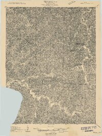
 1905 St. Clairsville1942 Print · USGSBelmont County at the start of the twentieth century was a landscape of steep ridges and vital transportation corridors. Researchers can trace the path of the National Road and locate early settlements and rail junctions like Fairpoint, Colerain, and Harrisville.2 unique versions available
 - 1905 Map of Flushing, 1946 Print
 1905 Flushing1946 Print · USGSEastern Ohio at the turn of the century shows a landscape defined by the National Turnpike and early rail lines. Genealogists can trace family footprints in Holloway, Sewellsville, and Morristown or along the winding Cleveland Lorain and Wheeling railroad.
 - 1909 Map of Antrim
 1909 Antrim1909 Print · USGSEastern Ohio at the turn of the century reveals a landscape of ridge-top farms and valley settlements centered around Antrim and Londonderry. Genealogists can trace family footprints across township lines to sites like Allen Chapel, Moccasin School, and Sewellsville.2 unique versions available
 - 1909 Map of Uhrichsville, 1956 Print
 1909 Uhrichsville1956 Print · USGSThe industrial valleys of Tuscarawas and Harrison Counties come alive in this early twentieth-century survey. Genealogists can trace family roots at Gnadenhutten, Goshen Beidler PO, and dozens of rural sites like Kennedy Church and Latto School.
End of results
Showing maps 1-9 of 9
Top cities of Harrison County
- Cadiz historical maps
- Hopedale historical maps
- Jewett historical maps
- Scio historical maps
- Bowerston historical maps
- Moorefield historical maps
See more
Frequently asked questions
- What are the different types of historical maps available for Harrison County?
- What is the oldest map of Harrison County?
- Where can I purchase historical maps of Harrison County for my home or office?
- Where can I download high-res historical maps of Harrison County?
- Are there historical topographic maps available for Harrison County?
- Is there historical aerial imagery available for Harrison County?
- Where are historical maps of Harrison County sourced from?