1940s Maps of Holmes County, Ohio
Explore 5 historic maps of Holmes County from the 1940s. These maps offer a rare glimpse into what life looked like during the 1940s — showing old roads, neighborhoods, homes, and landmarks that have changed or disappeared over time.
Whether you're researching your family's past, planning a metal detecting trip, or studying how Holmes County's landscape evolved across the 1940s, these high-resolution maps are a powerful tool for exploring the history of this region.
- Focus on a specific era: All maps on this page are from the 1940s, giving you a focused view of this time period.
- See what’s changed: Compare century-old streets, trails, and buildings to today's modern landscape using overlays and satellite layers.
- Research with precision: Use these maps for genealogy, historical research, land use analysis, or educational projects.
- View, download, or print: Maps are fully viewable online in high resolution, and can be downloaded or printed for your own records.
Start exploring Holmes County's history through authentic maps from the 1940s. This is your window into the past.
Holmes County, OH maps
(5)- 1943 Map of Millersburg
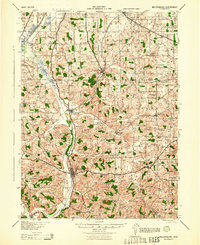 1943 Millersburg1943 Print · USGSHolmes County and southern Wayne County are shown in the 1940s as a landscape of small farms and rail-connected villages. Genealogists can locate numerous local institutions like Hazeldell Sch, follow the Pennsylvania RR through Millersburg, or find early Oil Wells.
 - 1943 Map of Coshocton
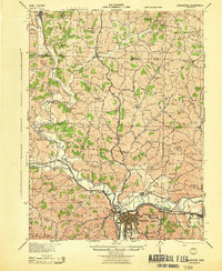 1943 Coshocton1943 Print · USGSCoshocton and its surrounding river valleys are captured here during the early years of the war, showcasing a dense network of rural schools and rail-fed towns. Researchers can locate the COUNTY INFIRMARY, trace the old CANAL route near Canal Lewisville, or find family sites near Soggy Hill Sch and Helmick Sta.
 - 1943 Map of Newcomerstown
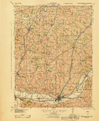 1943 Newcomerstown1943 Print · USGSThe Tuscarawas River valley was a thriving industrial and rail corridor during the mid-forties. Genealogists can locate family homesteads near dozens of rural schools like Goose Leg Sch, and trace river crossings at Sells Ford and Browning Ford.
 - 1943 Map of Loudonville
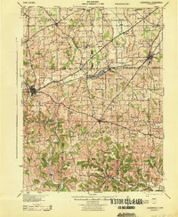 1943 Loudonville1943 Print · USGSAshland and Holmes counties during the early years of the war show a landscape defined by the PENNSYLVANIA rail line and the Mohican River. Genealogists can locate dozens of country schools like Ball Alley Sch and settlements such as Nashville or Big Prairie.
 - 1944 Map of Navarre
 1944 Navarre1944 Print · USGSDuring the mid-1940s, this portion of East Central Ohio was a thriving network of rail-towns and coal mines. Researchers can trace the Treaty Line, locate dozens of rural schoolhouses like Brush College Sch, and see the footprint of Brewster and Sugar Creek.
End of results
Showing maps 1-5 of 5
Top cities of Holmes County
- Berlin historical maps
- Walnut Creek historical maps
- Millersburg historical maps
- Killbuck historical maps
- Clark historical maps
- Holmesville historical maps
See more
Frequently asked questions
- What are the different types of historical maps available for Holmes County?
- What is the oldest map of Holmes County?
- Where can I purchase historical maps of Holmes County for my home or office?
- Where can I download high-res historical maps of Holmes County?
- Are there historical topographic maps available for Holmes County?
- Is there historical aerial imagery available for Holmes County?
- Where are historical maps of Holmes County sourced from?