1960s Maps of Holmes County, Ohio
Explore 18 historic maps of Holmes County from the 1960s. These maps offer a rare glimpse into what life looked like during the 1960s — showing old roads, neighborhoods, homes, and landmarks that have changed or disappeared over time.
Whether you're researching your family's past, planning a metal detecting trip, or studying how Holmes County's landscape evolved across the 1960s, these high-resolution maps are a powerful tool for exploring the history of this region.
- Focus on a specific era: All maps on this page are from the 1960s, giving you a focused view of this time period.
- See what’s changed: Compare century-old streets, trails, and buildings to today's modern landscape using overlays and satellite layers.
- Research with precision: Use these maps for genealogy, historical research, land use analysis, or educational projects.
- View, download, or print: Maps are fully viewable online in high resolution, and can be downloaded or printed for your own records.
Start exploring Holmes County's history through authentic maps from the 1960s. This is your window into the past.
Holmes County, OH maps
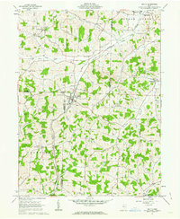
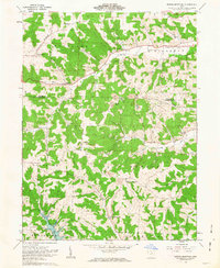
(18)- 1961 Map of Millersburg, 1962 Print
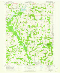
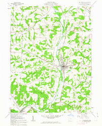 1961 Millersburg1962 Print · USGSThe village of Millersburg sits at a crossroads of rail and river in the early 1960s. Genealogists and historians can trace family locations at Oak Grove Cem and Locust Grove Ch, or locate old industrial sites like the Quarry and various Strip Mine works.4 unique versions available
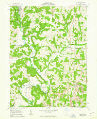
 - 1961 Map of Greer, 1963 Print
 1961 Greer1963 Print · USGSHolmes County was a land of river valleys and treaty boundaries during the early sixties. Researchers can trace family history through sites like Ullman Cem, the settlement of Greer, and the historic Greenville Treaty Line.3 unique versions available
 - 1961 Map of Loudonville, 1963 Print
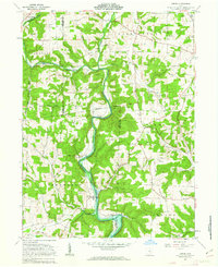
 1961 Loudonville1963 Print · USGSIn the early sixties, the Mohican River valley around Loudonville remained a landscape of active rail transport and rural industry. Researchers can trace family sites at County Line Cem, the local impact of the Mohicanville Dam, and the early oil and gas fields near McZena.3 unique versions available
 - 1961 Map of Fredericksburg, 1963 Print
 1961 Fredericksburg1963 Print · USGSThe rural landscapes of Wayne and Holmes counties are captured here in the early sixties, showing a dense network of country roads and farmsteads. Genealogists can locate family landmarks like Maysville Ch, Waynedale Sch, and the quiet hamlet of Calamoutier.2 unique versions available
 - 1961 Map of Baltic, 1963 Print
 1961 Baltic1963 Print · USGSThe tri-county border area of Tuscarawas, Holmes, and Coshocton comes into focus in the early sixties. Genealogists and local historians can locate rural landmarks like Mt Zion Cem, Union Valley Sch, and the Clay Pit Kilns near Baltic.2 unique versions available
 - 1961 Map of Sugarcreek, 1963 Print
 1961 Sugarcreek1963 Print · USGSThe Amish country of Holmes and Tuscarawas Counties is shown here in the early sixties, a landscape where historical boundaries and industrial growth intersect. Genealogists can locate family landmarks like Schrocks Cem, Fairview Sch, and the rail-side community of Sugarcreek.2 unique versions available
 - 1961 Map of Wilmot, 1963 Print
 1961 Wilmot1963 Print · USGSThe intersection of Wayne, Stark, and Holmes counties comes into focus during the early 1960s, showing a landscape defined by family farming and rural industry. Genealogists can trace family names through several burial grounds like Hershberger Cem and Weaver Cem, or locate local landmarks like the Treaty Line.3 unique versions available
 - 1961 Map of Brinkhaven, 1963 Print
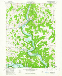 1961 Brinkhaven1963 Print · USGSIn the early sixties, the Mohican River valley supported a mix of rail transit and active drilling near Brinkhaven. Researchers can trace old family burial sites like Borden Cem and rural landmarks such as Tiverton Ch and Riley Chapel.4 unique versions available
 - 1961 Map of Holmesville, 1963 Print
 1961 Holmesville1963 Print · USGSThe agricultural and industrial character of the Wayne and Holmes County border is revealed in the early 1960s. Genealogists and historians can trace the Pennsylvania Railroad Grade through Holmesville or locate rural sites like Moorhead Ch and Franklin Sch.4 unique versions available
 - 1961 Map of Shreve, 1963 Print
 1961 Shreve1963 Print · USGSWayne and Holmes counties in the early sixties reveal a landscape of glacial lakes and established rail towns. Researchers can trace family roots through Shreve Cem and Bigelow Ch Cem or locate the lakeside communities of Lakeland Beach and Lakeville.3 unique versions available
 - 1961 Map of New Bedford, 1963 Print
 1961 New Bedford1963 Print · USGSThe rural borderlands of Holmes and Coshocton counties are captured here in the early sixties as a landscape of ridge-top farms and valley industry. Genealogists can locate family landmarks like Oak Hill Ch, Knob Cem, and the historic Becks Mills settlement.2 unique versions available
 - 1962 Map of Marion
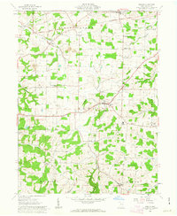
 1962 Marion1962 Print · USGSCentral Ohio during the post-war era showcases a dense network of railroad towns and emerging interstate highways. Genealogists can trace family roots in smaller settlements like Houcktown and Marseilles or locate landmarks near Indian Lake.
 - 1962 Map of Canton
 1962 Canton1962 Print · USGSThe industrial heartland of Eastern Ohio and Western Pennsylvania thrives in the early sixties as steel mills and rail lines dominate the river valleys. Genealogists and historians can trace local landmarks like McKinley National Memorial, Malone College, and industrial sites such as Republic Steel Corp.2 unique versions available
 - 1962 Map of Glenmont, 1963 Print
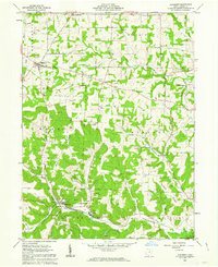 1962 Glenmont1963 Print · USGSIn the early 1960s, the Holmes County landscape was a mix of quiet rural townships and active resource extraction. Researchers can trace historic property boundaries along the Greenville Treaty Line or locate family sites near Sunnyside Cem and Welcome Ch.2 unique versions available
 - 1962 Map of Spring Mountain, 1963 Print
 1962 Spring Mountain1963 Print · USGSThe rolling hills of Coshocton County come into focus in the early sixties as a landscape of gas wells, strip mines, and remote hilltop cemeteries. Genealogists can trace family roots through sites like Union Grove Ch Cem, Fort Fizzle, and Dutch Run Ch.2 unique versions available
 - 1962 Map of Killbuck, 1963 Print
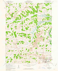
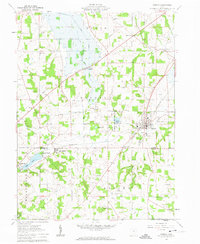
 1962 Killbuck1963 Print · USGSThe rural valleys of Holmes and Coshocton Counties are captured here in the early 1960s as a landscape of small rail-side hamlets and family farmsteads. Local historians can trace the PENNSYLVANIA line through Helmick or locate local landmarks like the Covered Bridge and Salem Cem.5 unique versions available
 - 1962 Map of Berlin, 1963 Print
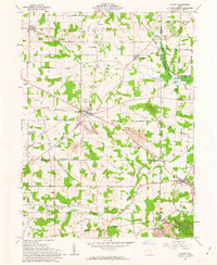
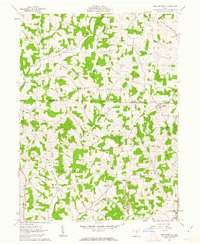
 1962 Berlin1963 Print · USGSHolmes County’s Amish Country landscape is captured here in the early sixties, showing a traditional network of crossroads and small farms. Genealogists can locate family-named landmarks like Troyer Sch, Millers Corners, and the historic Greenville Treaty Line.3 unique versions available
 - 1966 Map of Marion, 1968 Print
 1966 Marion1968 Print · USGSCentral Ohio in the mid-sixties is captured during a period of rapid highway expansion and industrial connectivity. Genealogists and historians can trace rail-and-river networks through towns like Marion, Urbana, and Mount Vernon, or locate landmarks such as Malabar Farm and Black Hand Rock.3 unique versions available
End of results
Showing maps 1-18 of 18
Top cities of Holmes County
- Berlin historical maps
- Walnut Creek historical maps
- Millersburg historical maps
- Killbuck historical maps
- Clark historical maps
- Holmesville historical maps
See more
Frequently asked questions
- What are the different types of historical maps available for Holmes County?
- What is the oldest map of Holmes County?
- Where can I purchase historical maps of Holmes County for my home or office?
- Where can I download high-res historical maps of Holmes County?
- Are there historical topographic maps available for Holmes County?
- Is there historical aerial imagery available for Holmes County?
- Where are historical maps of Holmes County sourced from?