Old Maps of Holmes County, Ohio for Metal Detecting
Plan your next treasure hunt with 125 historic maps of Holmes County. Find old homesites, ghost towns, trails, and gathering spots that may be lost to time — perfect for identifying promising metal detecting locations.
- Locate forgotten sites: Uncover places like long-lost settlements, abandoned rail lines, or gathering spots.
- Plan better hunts: Use map overlays combined with LiDAR or satellite views to narrow in on historically rich areas.
- Made for detectorists: Thousands of hobbyists use these maps to discover relics, coins, and hidden history.
Use these historic maps to boost your research and find new opportunities beneath the surface of Holmes County.
Holmes County, OH maps
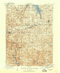
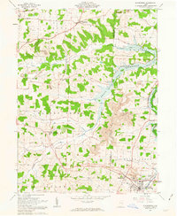
(125)- 1911 Map of Newcomerstown, 1959 Print
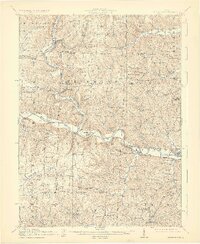
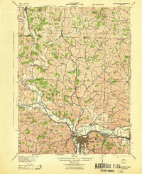
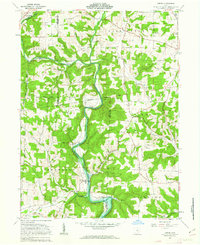
 1911 Newcomerstown1959 Print · USGSTuscarawas County in the early twentieth century is captured here as a corridor of heavy rail and old canal routes. Genealogists can locate family-named rural schools like Steitz School or May School and trace the original path of the Ohio Canal near Port Washington.
 - 1912 Map of Loudonville, 1958 Print
 1912 Loudonville1958 Print · USGSBefore modern highways rearranged rural Ohio, this area thrived as a network of rail-side towns and country schoolhouses. Genealogists can trace family footprints at Germany School, the Greenville Treaty Line, and the village of Shreve.
 - 1913 Map of Newcomerstown, 1943 Print
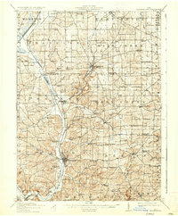
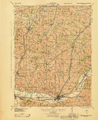
 1913 Newcomerstown1943 Print · USGSTuscarawas County's industrial and educational roots are on display in the years before the Great War. Genealogists and historians can trace the Pennsylvania and Ohio Canal, locate the West Lafayette College, and find family schoolhouses like Putt School and Steitz School.
 - 1913 Map of Brinkhaven, 1958 Print
 1913 Brinkhaven1958 Print · USGSCoshocton County was a landscape of steep ridges and river valleys just before the First World War. Researchers can locate dozens of country schoolhouses and churches, such as Nigger Run School, Tiverton Center, and Wilson Chapel.
 - 1913 Map of Coshocton, 1964 Print
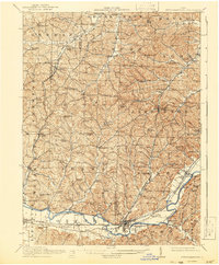
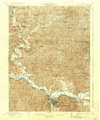
 1913 Coshocton1964 Print · USGSCoshocton and the Muskingum River headwaters are captured here just before the Great War, showing a landscape defined by the Ohio Canal and converging rail lines. Genealogists can trace family roots through dozens of rural schools like Soggy Hill School and vanished post offices like Clark PO.
 - 1914 Map of Navarre, 1940 Print
 1914 Navarre1940 Print · USGSNortheast Ohio’s industrial and rural landscape is shown here as the coal and rail era reached its peak. Genealogists can trace family roots through dozens of local schools like Frogpond School and follow the angled path of the historic Military Treaty Line.2 unique versions available
 - 1914 Map of Loudonville, 1944 Print
 1914 Loudonville1944 Print · USGSNorth-central Ohio is captured here in the years before the Great War, showing a dense network of hill-country farms and railroad towns. Genealogists can trace family roots through dozens of local landmarks like Germany School, Miley Crossroads, and the historic Greenville Treaty Line.
 - 1915 Map of Brinkhaven, 1925 Print
 1915 Brinkhaven1925 Print · USGSCoshocton and Knox counties come alive in the decade before the Great War, showing a network of river-valley rail towns and upland farmsteads. Genealogists can trace family footprints across dozens of local landmarks like Nigger Run School 23, Mohawk Village, and New Guilford.2 unique versions available
 - 1915 Map of Millersburg, 1935 Print
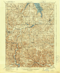
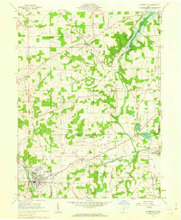
 1915 Millersburg1935 Print · USGSHolmes County and southern Wayne County appear here during the early twentieth century, showing a landscape defined by small farming hamlets and a dense network of country schools. Genealogists can trace family footprints near Millersburg or locate landmarks like the GREENVILLE TREATY LINE, Mount Hope, and the Indian Trail.2 unique versions available
 - 1915 Map of Coshocton, 1939 Print
 1915 Coshocton1939 Print · USGSCoshocton and the river forks are captured here just before the Great War, showing the region's transition from canal power to a rail-driven economy. Genealogists can locate dozens of numbered district schools and rural post offices like Bloomfield Clark PO, Roscoe, and Becks Mills.2 unique versions available
 - 1943 Map of Millersburg
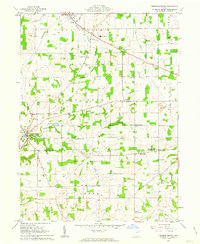
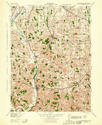 1943 Millersburg1943 Print · USGSHolmes County and southern Wayne County are shown in the 1940s as a landscape of small farms and rail-connected villages. Genealogists can locate numerous local institutions like Hazeldell Sch, follow the Pennsylvania RR through Millersburg, or find early Oil Wells.
 - 1943 Map of Coshocton
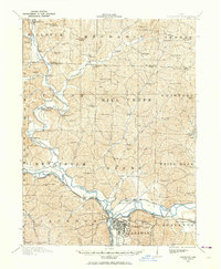
 1943 Coshocton1943 Print · USGSCoshocton and its surrounding river valleys are captured here during the early years of the war, showcasing a dense network of rural schools and rail-fed towns. Researchers can locate the COUNTY INFIRMARY, trace the old CANAL route near Canal Lewisville, or find family sites near Soggy Hill Sch and Helmick Sta.
 - 1943 Map of Newcomerstown
 1943 Newcomerstown1943 Print · USGSThe Tuscarawas River valley was a thriving industrial and rail corridor during the mid-forties. Genealogists can locate family homesteads near dozens of rural schools like Goose Leg Sch, and trace river crossings at Sells Ford and Browning Ford.
 - 1943 Map of Loudonville
 1943 Loudonville1943 Print · USGSAshland and Holmes counties during the early years of the war show a landscape defined by the PENNSYLVANIA rail line and the Mohican River. Genealogists can locate dozens of country schools like Ball Alley Sch and settlements such as Nashville or Big Prairie.
 - 1944 Map of Navarre
 1944 Navarre1944 Print · USGSDuring the mid-1940s, this portion of East Central Ohio was a thriving network of rail-towns and coal mines. Researchers can trace the Treaty Line, locate dozens of rural schoolhouses like Brush College Sch, and see the footprint of Brewster and Sugar Creek.
 - 1950 Map of Marion
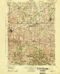
 1950 Marion1950 Print · USGSCentral Ohio was a powerhouse of rail and river industry at the mid-century point, serving as a vital corridor between the Great Lakes and the Ohio River valley. Genealogists and rail historians can trace the paths of the Erie RR and Nickel Plate Road through towns like Bucyrus, Galion, and Upper Sandusky.
 - 1951 Map of Canton
 1951 Canton1951 Print · USGSThe industrial heartland of Ohio and Pennsylvania reached its mid-century peak during this era of heavy rail and river transit. Genealogists and historians can trace the development of steel towns like Aliquippa and Weirton alongside the Ohio River and major lines of the Pennsylvania RR.
 - 1953 Map of Canton
 1953 Canton1953 Print · USGSThe industrial heartland of Ohio and Pennsylvania is captured at its mid-century peak in this detailed regional survey. Genealogists and historians can trace the vast rail networks of the Pennsylvania RR and find local landmarks like Nimisila Reservoir and Tappan Reservoir.
 - 1957 Map of Canton, 1971 Print
 1957 Canton1971 Print · USGSThe industrial heartland of eastern Ohio and western Pennsylvania comes alive in this mid-century survey of the Ohio River Valley. Trace the heritage of rail and river commerce through Pittsburgh, the massive steel towns along the Ohio River, and major junctions on the Pennsylvania RR.3 unique versions available
 - 1961 Map of Millersburg, 1962 Print
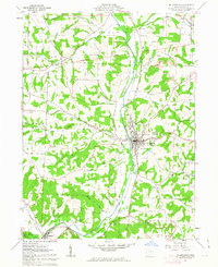 1961 Millersburg1962 Print · USGSThe village of Millersburg sits at a crossroads of rail and river in the early 1960s. Genealogists and historians can trace family locations at Oak Grove Cem and Locust Grove Ch, or locate old industrial sites like the Quarry and various Strip Mine works.4 unique versions available
 - 1961 Map of Greer, 1963 Print
 1961 Greer1963 Print · USGSHolmes County was a land of river valleys and treaty boundaries during the early sixties. Researchers can trace family history through sites like Ullman Cem, the settlement of Greer, and the historic Greenville Treaty Line.3 unique versions available
 - 1961 Map of Loudonville, 1963 Print
 1961 Loudonville1963 Print · USGSIn the early sixties, the Mohican River valley around Loudonville remained a landscape of active rail transport and rural industry. Researchers can trace family sites at County Line Cem, the local impact of the Mohicanville Dam, and the early oil and gas fields near McZena.3 unique versions available
 - 1961 Map of Fredericksburg, 1963 Print
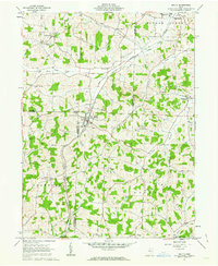
 1961 Fredericksburg1963 Print · USGSThe rural landscapes of Wayne and Holmes counties are captured here in the early sixties, showing a dense network of country roads and farmsteads. Genealogists can locate family landmarks like Maysville Ch, Waynedale Sch, and the quiet hamlet of Calamoutier.2 unique versions available
 - 1961 Map of Baltic, 1963 Print
 1961 Baltic1963 Print · USGSThe tri-county border area of Tuscarawas, Holmes, and Coshocton comes into focus in the early sixties. Genealogists and local historians can locate rural landmarks like Mt Zion Cem, Union Valley Sch, and the Clay Pit Kilns near Baltic.2 unique versions available
 - 1961 Map of Sugarcreek, 1963 Print
 1961 Sugarcreek1963 Print · USGSThe Amish country of Holmes and Tuscarawas Counties is shown here in the early sixties, a landscape where historical boundaries and industrial growth intersect. Genealogists can locate family landmarks like Schrocks Cem, Fairview Sch, and the rail-side community of Sugarcreek.2 unique versions available
Showing maps 1-25 of 125
Top cities of Holmes County
- Berlin historical maps
- Walnut Creek historical maps
- Millersburg historical maps
- Killbuck historical maps
- Clark historical maps
- Holmesville historical maps
See more
Frequently asked questions
- What are the different types of historical maps available for Holmes County?
- What is the oldest map of Holmes County?
- Where can I purchase historical maps of Holmes County for my home or office?
- Where can I download high-res historical maps of Holmes County?
- Are there historical topographic maps available for Holmes County?
- Is there historical aerial imagery available for Holmes County?
- Where are historical maps of Holmes County sourced from?