1900-1909 Maps of Jefferson County, Ohio
Explore 7 historic maps of Jefferson County from 1900-1909. These maps offer a rare glimpse into what life looked like during the 1900s — showing old roads, neighborhoods, homes, and landmarks that have changed or disappeared over time.
Whether you're researching your family's past, planning a metal detecting trip, or studying how Jefferson County's landscape evolved across the 1900s, these high-resolution maps are a powerful tool for exploring the history of this region.
- Focus on a specific era: All maps on this page are from the 1900s, giving you a focused view of this time period.
- See what’s changed: Compare century-old streets, trails, and buildings to today's modern landscape using overlays and satellite layers.
- Research with precision: Use these maps for genealogy, historical research, land use analysis, or educational projects.
- View, download, or print: Maps are fully viewable online in high resolution, and can be downloaded or printed for your own records.
Start exploring Jefferson County's history through authentic maps from the 1900s. This is your window into the past.
Jefferson County, OH maps
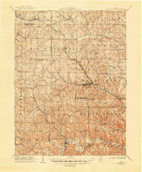
(7)- 1901 Map of Cadiz, 1954 Print
 1901 Cadiz1954 Print · USGSEastern Ohio at the dawn of the twentieth century was a landscape of ridge-top villages and bustling rail junctions. Trace the steam-era connections between Cadiz Junc and Jewett, or locate historic settlements like Bloomingdale and Amsterdam.2 unique versions available
 - 1902 Map of Wheeling
 1902 Wheeling1902 Print · USGSThe Ohio River valley at the start of the 1900s was a powerhouse of rail and river industry across West Virginia, Ohio, and Pennsylvania. Genealogists can trace family roots in early industrial hubs like Martins Ferry, locate historic landmarks like the S Bridge, or find riverfront settlements such as Beach Bottom and Yorkville.7 unique versions available
 - 1903 Map of Cadiz, 1941 Print
 1903 Cadiz1941 Print · USGSEastern Ohio at the turn of the century was a landscape of busy rail corridors and small valley towns. Genealogists and historians can trace old homesteads and rail stops near Amsterdam, Bloomingdale, and the junction at Jewett along the Wheeling and Lake Erie line.
 - 1904 Map of Wellsville
 1904 Wellsville1904 Print · USGSThe tri-state border region along the OHIO RIVER is captured here during the peak of its rail-and-river expansion. Genealogists can trace family footprints in Wellsville or find early rural landmarks like Grimm's Bridge and Cannon's Mill.3 unique versions available
 - 1904 Map of Steubenville
 1904 Steubenville1904 Print · USGSThe industrial heart of the Ohio River Valley comes to life in this early 1900s survey of the tri-state border region. Genealogists and historians can trace the early footprints of Steubenville, the rail junctions at Mingo Junction, and river crossings like Middle Ferry.5 unique versions available
 - 1905 Map of St. Clairsville, 1942 Print
 1905 St. Clairsville1942 Print · USGSBelmont County at the start of the twentieth century was a landscape of steep ridges and vital transportation corridors. Researchers can trace the path of the National Road and locate early settlements and rail junctions like Fairpoint, Colerain, and Harrisville.2 unique versions available
 - 1905 Map of Salineville, 1948 Print
 1905 Salineville1948 Print · USGSEastern Ohio at the turn of the century shows a landscape transitioning between agrarian roots and new industrial rail lines. Genealogists and researchers can trace family lands near Salineville and Bergholz, or locate rural hamlets like Summitville and Wattsville.
End of results
Showing maps 1-7 of 7
Top cities of Jefferson County
- Steubenville historical maps
- Toronto historical maps
- Wintersville historical maps
- Mingo Junction historical maps
- Tiltonsville historical maps
- Smithfield historical maps
See more
Frequently asked questions
- What are the different types of historical maps available for Jefferson County?
- What is the oldest map of Jefferson County?
- Where can I purchase historical maps of Jefferson County for my home or office?
- Where can I download high-res historical maps of Jefferson County?
- Are there historical topographic maps available for Jefferson County?
- Is there historical aerial imagery available for Jefferson County?
- Where are historical maps of Jefferson County sourced from?