Old Maps of Jefferson County, Ohio for Genealogy
Trace your family roots with 123 historic maps of Jefferson County. These high-res maps reveal old neighborhoods, homesites, landmarks, and streets — helping you uncover where your ancestors lived and how the area evolved over time.
- Explore historic neighborhoods: Identify where your relatives may have lived in the 1800s or 1900s.
- Compare maps over time: Trace the changes in streets, buildings, and landmarks for multi-generational research.
- Perfect for genealogy & ancestry research: Used by family historians and researchers to map out lineage and migration.
These maps are an incredible resource for exploring your personal connection to Jefferson County's past.
Jefferson County, OH maps
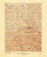
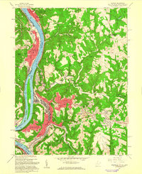
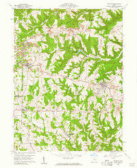
(123)- 1901 Map of Cadiz, 1954 Print
 1901 Cadiz1954 Print · USGSEastern Ohio at the dawn of the twentieth century was a landscape of ridge-top villages and bustling rail junctions. Trace the steam-era connections between Cadiz Junc and Jewett, or locate historic settlements like Bloomingdale and Amsterdam.2 unique versions available
 - 1902 Map of Wheeling
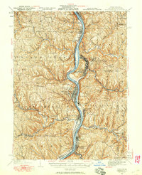
 1902 Wheeling1902 Print · USGSThe Ohio River valley at the start of the 1900s was a powerhouse of rail and river industry across West Virginia, Ohio, and Pennsylvania. Genealogists can trace family roots in early industrial hubs like Martins Ferry, locate historic landmarks like the S Bridge, or find riverfront settlements such as Beach Bottom and Yorkville.7 unique versions available
 - 1903 Map of Cadiz, 1941 Print
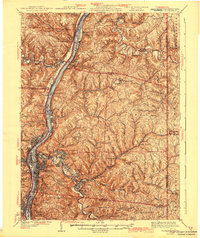
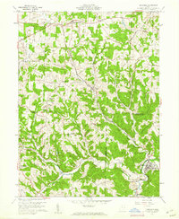
 1903 Cadiz1941 Print · USGSEastern Ohio at the turn of the century was a landscape of busy rail corridors and small valley towns. Genealogists and historians can trace old homesteads and rail stops near Amsterdam, Bloomingdale, and the junction at Jewett along the Wheeling and Lake Erie line.
 - 1904 Map of Wellsville
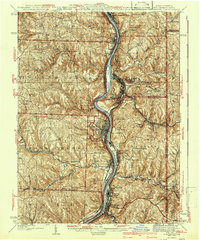
 1904 Wellsville1904 Print · USGSThe tri-state border region along the OHIO RIVER is captured here during the peak of its rail-and-river expansion. Genealogists can trace family footprints in Wellsville or find early rural landmarks like Grimm's Bridge and Cannon's Mill.3 unique versions available
 - 1904 Map of Steubenville
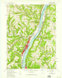
 1904 Steubenville1904 Print · USGSThe industrial heart of the Ohio River Valley comes to life in this early 1900s survey of the tri-state border region. Genealogists and historians can trace the early footprints of Steubenville, the rail junctions at Mingo Junction, and river crossings like Middle Ferry.5 unique versions available
 - 1905 Map of St. Clairsville, 1942 Print
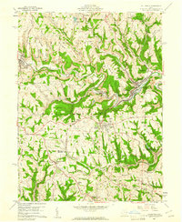
 1905 St. Clairsville1942 Print · USGSBelmont County at the start of the twentieth century was a landscape of steep ridges and vital transportation corridors. Researchers can trace the path of the National Road and locate early settlements and rail junctions like Fairpoint, Colerain, and Harrisville.2 unique versions available
 - 1905 Map of Salineville, 1948 Print
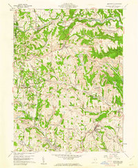
 1905 Salineville1948 Print · USGSEastern Ohio at the turn of the century shows a landscape transitioning between agrarian roots and new industrial rail lines. Genealogists and researchers can trace family lands near Salineville and Bergholz, or locate rural hamlets like Summitville and Wattsville.
 - 1935 Map of Wheeling, 1957 Print
 1935 Wheeling1957 Print · USGSThe industrial Ohio River valley is captured here in the mid-thirties, showing the complex rail and river networks of the tri-state area. Genealogists can trace family footprints across dozens of rural schools like Wells Sch and local landmarks such as Oglebay Park or the Mt Union Ch.
 - 1935 Map of Steubenville, 1958 Print
 1935 Steubenville1958 Print · USGSThe industrial heart of the Ohio River valley comes to life in this mid-century survey of the Ohio, West Virginia, and Pennsylvania borders. Genealogists and historians can trace the early footprints of Weirton, Steubenville, and smaller stops like Zalia and Reeds Mills.
 - 1937 Map of Wellsville, 1960 Print
 1937 Wellsville1960 Print · USGSThe Ohio River valley thrives as a Tri-State industrial hub in the years before the Second World War. Researchers can trace the riverfront rail lines of the Pennsylvania RR and locate vanished local landmarks like Pughtown PO and Nessly Chapel.
 - 1942 Map of Wheeling
 1942 Wheeling1942 Print · USGSThe Northern Panhandle and Ohio Valley are shown at their industrial peak during the mid-forties, spanning three states. Researchers can trace the riverfront rail networks and rural school districts like Hammond Sch, plus regional landmarks such as Oglebay Park and the Teachers College at West Liberty.2 unique versions available
 - 1942 Map of Steubenville
 1942 Steubenville1942 Print · USGSThe industrial corridor of the upper Ohio River comes to life here during the early 1940s. Genealogists can trace family roots through the streets of Steubenville and Weirton, or locate rural landmarks like Jefferson Sch and New Alexandria Sta.2 unique versions available
 - 1944 Map of Wellsville
 1944 Wellsville1944 Print · USGSThe industrial heart of the Ohio River valley comes to life in the 1940s, showing the bustling riverfronts of Wellsville and East Liverpool. Researchers can trace the Pennsylvania RR lines and find local landmarks like Grimms Bridge and Pughtown PO.2 unique versions available
 - 1951 Map of Canton
 1951 Canton1951 Print · USGSThe industrial heartland of Ohio and Pennsylvania reached its mid-century peak during this era of heavy rail and river transit. Genealogists and historians can trace the development of steel towns like Aliquippa and Weirton alongside the Ohio River and major lines of the Pennsylvania RR.
 - 1953 Map of Canton
 1953 Canton1953 Print · USGSThe industrial heartland of Ohio and Pennsylvania is captured at its mid-century peak in this detailed regional survey. Genealogists and historians can trace the vast rail networks of the Pennsylvania RR and find local landmarks like Nimisila Reservoir and Tappan Reservoir.
 - 1957 Map of Tiltonsville, 1959 Print
 1957 Tiltonsville1959 Print · USGSThe industrial Ohio River valley is captured here in the late fifties, showcasing the dense rail-and-river network of the Jefferson and Brooke County border. Researchers can trace family roots through sites like Hopewell Cem or explore the mid-century layout of Tiltonsville and the Wheeling-Ohio County Airport.2 unique versions available
 - 1957 Map of Canton, 1971 Print
 1957 Canton1971 Print · USGSThe industrial heartland of eastern Ohio and western Pennsylvania comes alive in this mid-century survey of the Ohio River Valley. Trace the heritage of rail and river commerce through Pittsburgh, the massive steel towns along the Ohio River, and major junctions on the Pennsylvania RR.3 unique versions available
 - 1958 Map of Steubenville West, 1959 Print
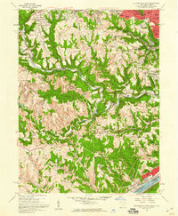 1958 Steubenville West1959 Print · USGSJefferson County in the late fifties shows the industrial pulse of the Ohio River valley and its surrounding hills. Researchers can trace the mid-century footprints of Mingo Junction, locate the Steubenville Pier Airport, and find family sites near Union Cemetery or Tent Ch.2 unique versions available
 - 1958 Map of Steubenville East, 1959 Print
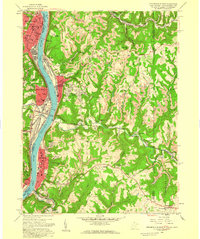 1958 Steubenville East1959 Print · USGSSteubenville and the Ohio River valley are shown in detail during the late fifties as industrial growth climbed the surrounding bluffs. Researchers can trace local landmarks like the College of Steubenville, Mingo Cem, and the rail lines through Colliers.2 unique versions available
 - 1958 Map of Knoxville, 1960 Print
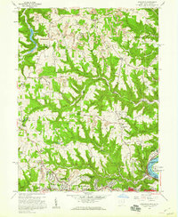 1958 Knoxville1960 Print · USGSJefferson County was undergoing a mid-century shift toward suburban growth and industrial extraction in the late fifties. Genealogists and local historians can trace family-named sites like Shelley Cem and Norton Hill, alongside landmarks like Jefferson Union Sch and the Toronto Airport.2 unique versions available
 - 1958 Map of Weirton, 1960 Print
 1958 Weirton1960 Print · USGSWeirton and the surrounding Ohio River valley are shown here during a decade of significant post-war growth. Researchers can trace family history through numerous labeled schools and landmarks like Holidays Cove and Three Springs Cem.2 unique versions available
 - 1960 Map of Bergholz, 1961 Print
 1960 Bergholz1961 Print · USGSEastern Ohio coal and rail country comes to life in the early sixties as industrial mining expands around the village of Bergholz. Genealogists and researchers can trace family roots at Spyder Cem, Palmer Cem, or the Chestnut Ridge Ch.4 unique versions available
 - 1960 Map of Dillonvale, 1961 Print
 1960 Dillonvale1961 Print · USGSEastern Ohio coal country was in the midst of a mining boom in the early sixties, leaving a landscape defined by industry and deep-seated local roots. Genealogists and historians can trace family locations through numerous sites like St Casimirs Ch, Olszeski Town, and Highland Cem.5 unique versions available
 - 1960 Map of Smithfield, 1961 Print
 1960 Smithfield1961 Print · USGSJefferson County at the dawn of the sixties shows a landscape transformed by industry and rail. Genealogists can trace family roots through Pine Run Cem and Township Cem, or locate old rail stops like Weems (Smithfield Sta).4 unique versions available
 - 1960 Map of Richmond, 1961 Print
 1960 Richmond1961 Print · USGSJefferson County in the early sixties was a landscape of deep-cut ridges and active industry. Researchers can trace family sites at Old Annapolis Cem, explore the grounds of St John Vianney Seminary, or locate early Strip Mines near Richmond.3 unique versions available
Showing maps 1-25 of 123
Top cities of Jefferson County
- Steubenville historical maps
- Toronto historical maps
- Wintersville historical maps
- Mingo Junction historical maps
- Tiltonsville historical maps
- Smithfield historical maps
See more
Frequently asked questions
- What are the different types of historical maps available for Jefferson County?
- What is the oldest map of Jefferson County?
- Where can I purchase historical maps of Jefferson County for my home or office?
- Where can I download high-res historical maps of Jefferson County?
- Are there historical topographic maps available for Jefferson County?
- Is there historical aerial imagery available for Jefferson County?
- Where are historical maps of Jefferson County sourced from?