1900-1909 Maps of Lawrence County, Ohio
Explore 10 historic maps of Lawrence County from 1900-1909. These maps offer a rare glimpse into what life looked like during the 1900s — showing old roads, neighborhoods, homes, and landmarks that have changed or disappeared over time.
Whether you're researching your family's past, planning a metal detecting trip, or studying how Lawrence County's landscape evolved across the 1900s, these high-resolution maps are a powerful tool for exploring the history of this region.
- Focus on a specific era: All maps on this page are from the 1900s, giving you a focused view of this time period.
- See what’s changed: Compare century-old streets, trails, and buildings to today's modern landscape using overlays and satellite layers.
- Research with precision: Use these maps for genealogy, historical research, land use analysis, or educational projects.
- View, download, or print: Maps are fully viewable online in high resolution, and can be downloaded or printed for your own records.
Start exploring Lawrence County's history through authentic maps from the 1900s. This is your window into the past.
Lawrence County, OH maps
(10)- 1900 Map of Ironton, 1918 Print
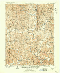
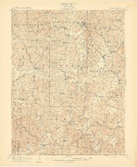
 1900 Ironton1918 Print · USGSThe Ohio River valley and the iron-rich hills of Lawrence County are seen here at the turn of the century during a peak in industrial activity. Genealogists and historians can trace defunct post offices like Orr P.O. and explore the rail corridors of the Ironton R.R. and Cincinnati Hamilton & Dayton R.R.2 unique versions available
 - 1901 Map of Guyandot, 1953 Print
 1901 Guyandot1953 Print · USGSThe Ohio River valley at the start of the twentieth century shows a bustling corridor of industry and river commerce. Genealogists and historians can trace the early footprints of Huntington and Ceredo alongside early rail routes like the Baltimore and Ohio RR.
 - 1901 Map of Ceredo, 1953 Print
 1901 Ceredo1953 Print · USGSThe tri-state convergence of West Virginia, Ohio, and Kentucky comes alive in this early 20th-century survey of the Ohio River valley. Genealogists and rail historians can trace the vital transport networks of Kenova and Ceredo, alongside family-named landmarks like Walker Br and Rice Run.2 unique versions available
 - 1902 Map of Guyandot
 1902 Guyandot1902 Print · USGSThe industrial hub of Huntington and the river town of Guyandot sit at the center of this early century border survey. Genealogists can trace family names and small settlements along Twelvepole Creek and Russell Creek, including Lavalette, Shoals, and Dickson.4 unique versions available
 - 1903 Map of Kenova
 1903 Kenova1903 Print · USGSThe tri-state river junction at Ashland and Kenova was a bustling industrial hub after the turn of the century. Trace early rail lines and mining settlements like Coalton and Boghead, or locate family landmarks along the Little Sandy River and Means Tunnel.5 unique versions available
 - 1904 Map of Kenova
 1904 Kenova1904 Print · USGSThe tri-state confluence of the Ohio River and Big Sandy River hums with early industrial activity at the start of the century. Genealogists can trace rail-side settlements and remote homesteads along Blaine Creek and near Mt Savage or Webbville.
 - 1906 Map of Bidwell, 1954 Print
 1906 Bidwell1954 Print · USGSGallia County at the turn of the century is a network of small townships and valley settlements connected by the Gallipolis and Chillicothe RR. Researchers can trace rural life through a wealth of local landmarks like Centerville Thurman PO, Ghee Bridge, and the Tomato Valley School.
 - 1906 Map of Athalia, 1956 Print
 1906 Athalia1956 Print · USGSLawrence and Gallia counties in the early 1900s are captured here as a landscape of river ferries and ridge-top farm communities. You can trace early post offices at Willowwood, follow the Baltimore and Ohio RR, or locate old river crossings like the Crown City Ferry.
 - 1908 Map of Bidwell
 1908 Bidwell1908 Print · USGSGallia County at the turn of the century is a landscape of creek-side hamlets and hill-country schools. Genealogists can trace family roots through numerous local landmarks like Tomato Valley School, Tabor Church, and the Centerville Thurman P O post office.2 unique versions available
 - 1908 Map of Athalia
 1908 Athalia1908 Print · USGSThe Ohio River borderlands in the early twentieth century were a network of ferry crossings and small river towns. Genealogists can trace family names and farmsteads near Athalia, Crown City, and the Baltimore and Ohio RR corridor.3 unique versions available
End of results
Showing maps 1-10 of 10
Top cities of Lawrence County
- Ironton historical maps
- South Point historical maps
- Coal Grove historical maps
- Chesapeake historical maps
- Proctorville historical maps
- Athalia historical maps
See more
Frequently asked questions
- What are the different types of historical maps available for Lawrence County?
- What is the oldest map of Lawrence County?
- Where can I purchase historical maps of Lawrence County for my home or office?
- Where can I download high-res historical maps of Lawrence County?
- Are there historical topographic maps available for Lawrence County?
- Is there historical aerial imagery available for Lawrence County?
- Where are historical maps of Lawrence County sourced from?