1910s Maps of Licking County, Ohio
Explore 7 historic maps of Licking County from the 1910s. These maps offer a rare glimpse into what life looked like during the 1910s — showing old roads, neighborhoods, homes, and landmarks that have changed or disappeared over time.
Whether you're researching your family's past, planning a metal detecting trip, or studying how Licking County's landscape evolved across the 1910s, these high-resolution maps are a powerful tool for exploring the history of this region.
- Focus on a specific era: All maps on this page are from the 1910s, giving you a focused view of this time period.
- See what’s changed: Compare century-old streets, trails, and buildings to today's modern landscape using overlays and satellite layers.
- Research with precision: Use these maps for genealogy, historical research, land use analysis, or educational projects.
- View, download, or print: Maps are fully viewable online in high resolution, and can be downloaded or printed for your own records.
Start exploring Licking County's history through authentic maps from the 1910s. This is your window into the past.
Licking County, OH maps
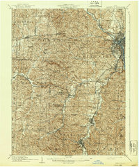
(7)- 1910 Map of Frazeysburg, 1937 Print
 1910 Frazeysburg1937 Print · USGSMuskingum and Licking Counties are captured here during a pivotal era of rail dominance and canal obsolescence. Researchers can locate vanished rural schoolhouses like Pisgah School or trace the early paths of the Ohio Canal near Dresden.2 unique versions available
 - 1910 Map of Zanesville, 1939 Print
 1910 Zanesville1939 Print · USGSMuskingum and Perry counties are shown here in the early twentieth century as Zanesville emerged as a powerhouse of rail and river commerce. Researchers can trace historic transport routes like the National Road or locate local landmarks such as Moxahala Park and the Fultonham (Axline PO).2 unique versions available
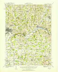
 - 1910 Map of Granville, 1944 Print
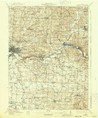
 1910 Granville1944 Print · USGSLicking County at the dawn of the automobile era shows a landscape of tightly-knit farming townships and busy rail corridors. Genealogists can locate family-named landmarks like Hazelton Corners, rural congregations at Wesley Chapel, and numerous local schools such as Wright School.
 - 1912 Map of Gambier, 1958 Print
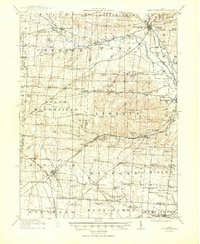
 1912 Gambier1958 Print · USGSKnox County is captured at a fascinating moment when rural hamlets and small colleges thrived alongside expanding rail lines. Genealogists can locate dozens of country schools like Wildcat School and trace ancestors near Monroe Mills or the Democracy P O.2 unique versions available
 - 1914 Map of Gambier, 1942 Print
 1914 Gambier1942 Print · USGSKnox County in the early twentieth century is captured here as a thriving network of rail-connected towns and rural school districts. Genealogists can locate family-named landmarks like Pike School and Bedell School or trace the early campus of Kenyon College and the State Tuberculosis Hospital.
 - 1915 Map of Marengo, 1946 Print
 1915 Marengo1946 Print · USGSMorrow and Delaware counties are shown in detail during the heyday of the steam railroad and the one-room schoolhouse. Genealogists and historians can locate vanished local landmarks like Swamp Angel School, the County Infirmary, and the Treaty Line.
 - 1915 Map of Fredericktown, 1950 Print
 1915 Fredericktown1950 Print · USGSKnox and Morrow Counties are shown here during the height of the steam-rail era. Genealogists can locate dozens of country schoolhouses like Salem and Updike, alongside family landmarks such as Braddock Mound and the County Infirmary.
End of results
Showing maps 1-7 of 7
Top cities of Licking County
Frequently asked questions
- What are the different types of historical maps available for Licking County?
- What is the oldest map of Licking County?
- Where can I purchase historical maps of Licking County for my home or office?
- Where can I download high-res historical maps of Licking County?
- Are there historical topographic maps available for Licking County?
- Is there historical aerial imagery available for Licking County?
- Where are historical maps of Licking County sourced from?