1940s Maps of Licking County, Ohio
Explore 5 historic maps of Licking County from the 1940s. These maps offer a rare glimpse into what life looked like during the 1940s — showing old roads, neighborhoods, homes, and landmarks that have changed or disappeared over time.
Whether you're researching your family's past, planning a metal detecting trip, or studying how Licking County's landscape evolved across the 1940s, these high-resolution maps are a powerful tool for exploring the history of this region.
- Focus on a specific era: All maps on this page are from the 1940s, giving you a focused view of this time period.
- See what’s changed: Compare century-old streets, trails, and buildings to today's modern landscape using overlays and satellite layers.
- Research with precision: Use these maps for genealogy, historical research, land use analysis, or educational projects.
- View, download, or print: Maps are fully viewable online in high resolution, and can be downloaded or printed for your own records.
Start exploring Licking County's history through authentic maps from the 1940s. This is your window into the past.
Licking County, OH maps
(5)- 1943 Map of Gambier
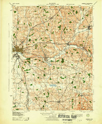 1943 Gambier1943 Print · USGSKnox County during the Second World War shows a landscape of institutional growth and deep-rooted rural communities. Genealogists can trace family footprints across dozens of local schoolhouses like Cherry Hall Sch and historic centers such as Democracy P O or Martinsburg.
 - 1943 Map of Marengo
 1943 Marengo1943 Print · USGSCentral Ohio's agricultural heartland is documented here during the early war years, showing a landscape defined by small-town rail hubs and a dense network of rural schoolhouses. Researchers can trace family history through dozens of named sites like Chestnut Grove Sch, the County Infirmary, and settlements such as Westfield and Fulton.
 - 1943 Map of East Columbus
 1943 East Columbus1943 Print · USGSEastern Columbus and the Refugee Tract are captured here during the mobilization of the early 1940s. Genealogists and historians can trace the foundations of modern aviation at Port Columbus or find vanished landmarks like the Childrens Home and Norton Field.
 - 1943 Map of Fredericktown
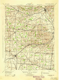 1943 Fredericktown1943 Print · USGSRural Knox County is captured here in the 1940s, showing a landscape of small townships connected by the Baltimore and Ohio RR and local schoolhouse districts. Genealogists can trace family footprints at Woodland Hall Sch, Bethel Ch, and ancient landmarks like Raleigh Mound.
 - 1947 Map of Columbus, 1948 Print
 1947 Columbus1948 Print · USGSCentral Ohio in the late 1940s is captured in this survey, showing the post-war transition of its rail hubs and military airfield expansions. Genealogists and historians can trace the paths of the Ohio Canal, the Pennsylvania RR lines, and the Camp Sherman Military Reservation.
End of results
Showing maps 1-5 of 5
Top cities of Licking County
Frequently asked questions
- What are the different types of historical maps available for Licking County?
- What is the oldest map of Licking County?
- Where can I purchase historical maps of Licking County for my home or office?
- Where can I download high-res historical maps of Licking County?
- Are there historical topographic maps available for Licking County?
- Is there historical aerial imagery available for Licking County?
- Where are historical maps of Licking County sourced from?