1900-1909 Maps of Lucas County, Ohio
Explore 6 historic maps of Lucas County from 1900-1909. These maps offer a rare glimpse into what life looked like during the 1900s — showing old roads, neighborhoods, homes, and landmarks that have changed or disappeared over time.
Whether you're researching your family's past, planning a metal detecting trip, or studying how Lucas County's landscape evolved across the 1900s, these high-resolution maps are a powerful tool for exploring the history of this region.
- Focus on a specific era: All maps on this page are from the 1900s, giving you a focused view of this time period.
- See what’s changed: Compare century-old streets, trails, and buildings to today's modern landscape using overlays and satellite layers.
- Research with precision: Use these maps for genealogy, historical research, land use analysis, or educational projects.
- View, download, or print: Maps are fully viewable online in high resolution, and can be downloaded or printed for your own records.
Start exploring Lucas County's history through authentic maps from the 1900s. This is your window into the past.
Lucas County, OH maps
(6)- 1900 Map of Maumee Bay, 1921 Print
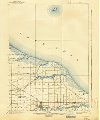
 1900 Maumee Bay1921 Print · USGSNorthwest Ohio and the Lake Erie shoreline are shown here just as the regions rail and energy sectors were maturing. Genealogists and historians can locate vanished post offices at Shepardsville Bono P. O. and trace early industrial sites like the Oil Wells and Coke Ovens near Curtice.2 unique versions available
 - 1900 Map of Toledo, 1932 Print
 1900 Toledo1932 Print · USGSToledo and the lower Maumee River valley are shown at the height of the railroad era, as the city expanded into an industrial powerhouse. Researchers can trace early infrastructure like the Michigan Division Canal and locate historic sites like the Toledo Insane Asylum or the Oil Wells near Lime City.
 - 1900 Map of Oak Harbor, 1943 Print
 1900 Oak Harbor1943 Print · USGSOttawa County shorelines and rail hubs are preserved here at the turn of the century, showing the region before modern development. Genealogists and historians can trace the early layouts of Oak Harbor, the military grounds at Camp Perry, and the path of the Toledo Div. railroad.2 unique versions available
 - 1901 Map of Bowling Green, 1958 Print
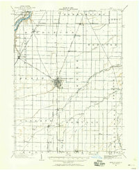 1901 Bowling Green1958 Print · USGSWood County at the turn of the century is a hub of steam and rail traffic centered on the growing seat of Bowling Green. Researchers can trace old family sites and rural settlements like Hull Prairie, Tontogany, and Jerry City across a landscape of early railroad lines.
 - 1903 Map of Bowling Green
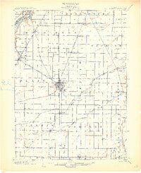 1903 Bowling Green1903 Print · USGSWood County at the turn of the century is a dense web of steam railroads and electric interurban lines connecting agricultural hubs. Researchers can trace the path of the Miami and Erie Canal or locate small settlements like Sugar Ridge, Tontogany, and Jerry City.3 unique versions available
 - 1909 Map of Mc Clure, 1936 Print
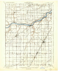 1909 Mc Clure1936 Print · USGSNorthwest Ohio's agricultural and transit heartland is captured here at the start of the twentieth century. Genealogists and rail historians can trace the paths of the Wabash RR and the Electric Detroit and Toledo Line as they connected towns like Mc Clure and Weston.2 unique versions available
End of results
Showing maps 1-6 of 6
Top cities of Lucas County
- Toledo historical maps
- Oregon historical maps
- Sylvania historical maps
- Maumee historical maps
- Monclova historical maps
- Waterville historical maps
See more
Frequently asked questions
- What are the different types of historical maps available for Lucas County?
- What is the oldest map of Lucas County?
- Where can I purchase historical maps of Lucas County for my home or office?
- Where can I download high-res historical maps of Lucas County?
- Are there historical topographic maps available for Lucas County?
- Is there historical aerial imagery available for Lucas County?
- Where are historical maps of Lucas County sourced from?