1990s Maps of Lucas County, Ohio
Explore 3 historic maps of Lucas County from the 1990s. These maps offer a rare glimpse into what life looked like during the 1990s — showing old roads, neighborhoods, homes, and landmarks that have changed or disappeared over time.
Whether you're researching your family's past, planning a metal detecting trip, or studying how Lucas County's landscape evolved across the 1990s, these high-resolution maps are a powerful tool for exploring the history of this region.
- Focus on a specific era: All maps on this page are from the 1990s, giving you a focused view of this time period.
- See what’s changed: Compare century-old streets, trails, and buildings to today's modern landscape using overlays and satellite layers.
- Research with precision: Use these maps for genealogy, historical research, land use analysis, or educational projects.
- View, download, or print: Maps are fully viewable online in high resolution, and can be downloaded or printed for your own records.
Start exploring Lucas County's history through authentic maps from the 1990s. This is your window into the past.
Lucas County, OH maps
(3)- 1994 Map of Walbridge, 1998 Print
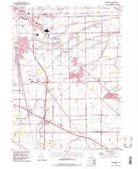 1994 Walbridge1998 Print · USGSWood County and Lucas County geography in the 1990s reveals a landscape shaped by massive rail yards and the Ohio Turnpike. Trace local history at Millbury, Zion Ch, and the extensive Walbridge Yard during this era of regional growth.
 - 1994 Map of Maumee, 1998 Print
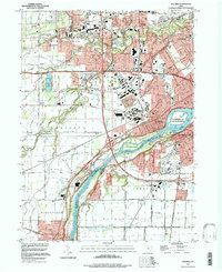 1994 Maumee1998 Print · USGSMaumee and Perrysburg are shown at the end of the twentieth century, anchored by the river and its historic military memorials. Researchers can trace the development of small settlements like Monclova and find sites such as Fort Meigs State Memorial and Riverside Cem.
 - 1994 Map of Bowling Green North, 1998 Print
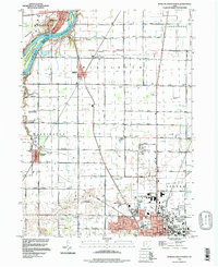 1994 Bowling Green North1998 Print · USGSThe Maumee River and the expanding campus of Bowling Green define this Wood County landscape in the mid-1990s. Genealogists can trace family names through the Union Hill Cem and Miltonville Cem or locate the old Plain Ch among the structured farmlands.
End of results
Showing maps 1-3 of 3
Top cities of Lucas County
- Toledo historical maps
- Oregon historical maps
- Sylvania historical maps
- Maumee historical maps
- Monclova historical maps
- Waterville historical maps
See more
Frequently asked questions
- What are the different types of historical maps available for Lucas County?
- What is the oldest map of Lucas County?
- Where can I purchase historical maps of Lucas County for my home or office?
- Where can I download high-res historical maps of Lucas County?
- Are there historical topographic maps available for Lucas County?
- Is there historical aerial imagery available for Lucas County?
- Where are historical maps of Lucas County sourced from?