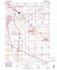
1994 Map of Walbridge
USGS Topo · Published 1998About this map
The Walbridge Yard serves as a massive industrial anchor in this 1990s landscape, illustrating the heavy rail infrastructure that defined the region southeast of Oregon. This era shows a complex intersection of transport and drainage, where the Ohio Turnpike cuts across the flat terrain of the Lake and Clay townships. Local landmarks like Metcalf Field and the Drive-in Theater near Millbury reflect the mid-century development patterns that persisted into the late twentieth century. Genealogists can find important sites like Zion Ch, Lake Cem, and Roselawn Memorial Park (Cemetery) nestled between expanding residential areas like Woodville Gardens and Cresceus Farms. The map also details the natural hydrology of the area, featuring the winding paths of Wolf Creek, Dry Creek, and Little Cedar Creek.
Find a feature on this map
67 named features on this map. Tap any name to fly to it.
Don’t see what you’re looking for? This feature index may not catch every label — zoom into the map to look around manually.
Map Details
Editions of this 1994 Walbridge Map
This is the sole edition of this map. No revisions or reprints were ever made.
Other maps of this area

1900 · Maumee Bay
USGS Topo · 1:62,500

1900 · Toledo
USGS Topo · 1:62,500

1901 · Bowling Green
USGS Topo · 1:62,500

1901 · Elmore
USGS Topo · 1:62,500

1903 · Bowling Green
USGS Topo · 1:62,500

1903 · Elmore
USGS Topo · 1:62,500

1934 · Reno Beach
USGS Topo · 1:24,000

1934 · Point Place
USGS Topo · 1:24,000

1934 · Rossford
USGS Topo · 1:24,000

1935 · Walbridge
USGS Topo · 1:24,000