Old Maps of Oregon, Ohio for Metal Detecting
Plan your next treasure hunt with 50 historic maps of Oregon. Find old homesites, ghost towns, trails, and gathering spots that may be lost to time — perfect for identifying promising metal detecting locations.
- Locate forgotten sites: Uncover places like long-lost settlements, abandoned rail lines, or gathering spots.
- Plan better hunts: Use map overlays combined with LiDAR or satellite views to narrow in on historically rich areas.
- Made for detectorists: Thousands of hobbyists use these maps to discover relics, coins, and hidden history.
Use these historic maps to boost your research and find new opportunities beneath the surface of Oregon.
Oregon, OH maps
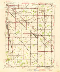
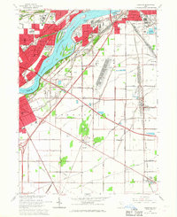
(50)- 1900 Map of Maumee Bay, 1921 Print
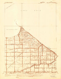
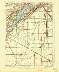
 1900 Maumee Bay1921 Print · USGSNorthwest Ohio and the Lake Erie shoreline are shown here just as the regions rail and energy sectors were maturing. Genealogists and historians can locate vanished post offices at Shepardsville Bono P. O. and trace early industrial sites like the Oil Wells and Coke Ovens near Curtice.2 unique versions available
 - 1900 Map of Toledo, 1932 Print
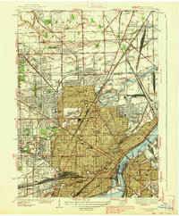
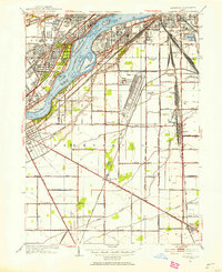
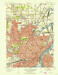
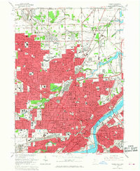
 1900 Toledo1932 Print · USGSToledo and the lower Maumee River valley are shown at the height of the railroad era, as the city expanded into an industrial powerhouse. Researchers can trace early infrastructure like the Michigan Division Canal and locate historic sites like the Toledo Insane Asylum or the Oil Wells near Lime City.
 - 1934 Map of Reno Beach
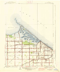
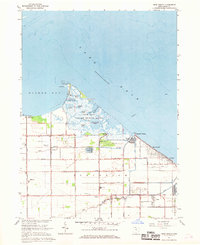
 1934 Reno Beach1934 Print · USGSThe Lucas County shoreline in the mid-1930s reveals a unique landscape of lakefront clubs and reclaimed marshland. Genealogists and local historians can trace the foundations of the Jerusalem community through landmarks like St Lukes Ch, Bono, and the Reno Sch.
 - 1934 Map of Point Place
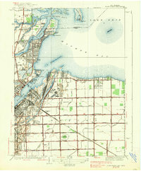
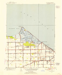
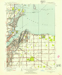
 1934 Point Place1934 Print · USGSThe Lake Erie shoreline near Toledo comes to life in the mid-1930s, showing a landscape defined by maritime trade and residential growth. Genealogists and historians can trace family locations near Point Place, Momineetown, and landmarks like the Toledo Yacht Club.
 - 1934 Map of Rossford
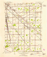
 1934 Rossford1934 Print · USGSWood County was a hub of transit and industry in the 1930s, where the Maumee River met a complex web of rail yards and highways. Genealogists can locate family landmarks like Eagle Point Colony, Sunshine Cem, and the old schools at Lark Sch and Glenwood Sch.
 - 1935 Map of Walbridge
 1935 Walbridge1935 Print · USGSThe rail-and-road corridors of Northwest Ohio come alive in this mid-1930s survey of the Walbridge and Millbury area. Genealogists and researchers can pinpoint family landmarks like Hayes Place, the Black Swamp Ch, and early aviation at the Toledo Landing Field.
 - 1938 Map of Walbridge
 1938 Walbridge1938 Print · USGSNorthwest Ohio at the height of its rail-and-road expansion shows a landscape defined by industrial hubs and developing neighborhoods. Genealogists and historians can trace family locations near Walbridge Yard, Millbury, and rural landmarks like the Allen Cem.2 unique versions available
 - 1938 Map of Reno Beach
 1938 Reno Beach1938 Print · USGSCoastal Lucas County comes alive in this pre-war survey of the Lake Erie marshes and beach communities. Researchers can trace the layout of Bono and Reno Beach or locate vanished local landmarks like Cement Block Sch and the Lakemont Golf Club.2 unique versions available
 - 1938 Map of Toledo
 1938 Toledo1938 Print · USGSIn the late thirties, this industrial hub was defined by the confluence of the Maumee River and an immense railroad network. Genealogists and historians can trace the early layout of Toledo University, numerous family cemeteries like Southard Cem, and rail landmarks including Air Line Junction.2 unique versions available
 - 1938 Map of Point Place
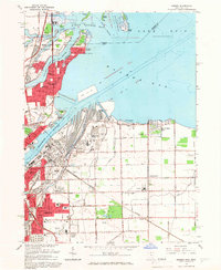
 1938 Point Place1938 Print · USGSCoastal life and heavy industry intersect along Maumee Bay in the late thirties as the region’s rail and maritime networks expanded. Researchers can trace the heritage of Point Place, the waterfront Naval Armory, and rural settlements like Momeneetown and Booth.2 unique versions available
 - 1938 Map of Rossford
 1938 Rossford1938 Print · USGSThe industrial Maumee River valley comes to life in the 1930s, showing a landscape defined by massive rail yards and river islands. Genealogists and local historians can trace the foundations of Eagle Point Colony, the remote Jessie Hill Mission, and old rail hubs like Stanley Yard.
 - 1951 Map of Rossford, 1953 Print
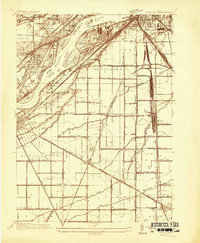
 1951 Rossford1953 Print · USGSWood County’s industrial and rail infrastructure dominates the Maumee River landscape during the early 1950s. Genealogists and local historians can trace the development of Lime City and Moline or locate landmarks like the Rossford Ordnance Depot and Sunshine Cem.
 - 1952 Map of Reno Beach, 1953 Print
 1952 Reno Beach1953 Print · USGSThe Lucas County shoreline and its intricate network of marshes and canals are captured here in the early fifties. Local historians can trace the development of waterfront communities like Reno Beach and Bono alongside landmarks like St Lukes Ch and the Cedar Point Club.
 - 1952 Map of Walbridge, 1953 Print
 1952 Walbridge1953 Print · USGSThe rural landscapes and rail hubs south of Toledo are captured here in the early fifties, showing the area's transition into a modern industrial corridor. Genealogists and historians can trace family roots at Lake Cem, Mound View, and the long-standing Black Swamp Ch.
 - 1952 Map of Toledo, 1954 Print
 1952 Toledo1954 Print · USGSToledo at the height of its mid-century industrial era shows a landscape defined by massive rail yards and riverfront commerce. Genealogists can trace family neighborhoods near Woodlawn Cemetery, St Vincent Hospital, and the many tracks of the New York Central.2 unique versions available
 - 1952 Map of Point Place, 1954 Print
 1952 Point Place1954 Print · USGSThe Lake Erie shoreline near Toledo comes alive in this early fifties survey of the Maumee River mouth and its surrounding industrial rail yards. Genealogists and local historians can locate long-standing landmarks like St Ignatius Ch, Pearson State Park, and the old Drive-in Theater.
 - 1956 Map of Toledo, 1968 Print
 1956 Toledo1968 Print · USGSNorthwest Ohio and the Lake Erie shoreline are shown in detail during the late fifties, showcasing a landscape of heavy industry, railroads, and island communities. Genealogists and historians can trace rail networks like the Chesapeake & Ohio RR or locate landmarks such as the Erie Proving Ground and Kelleys Island.4 unique versions available
 - 1961 Map of Toledo
 1961 Toledo1961 Print · USGSThe western basin of Lake Erie and the industrial heart of Northern Ohio are captured here during the post-war era. Researchers can trace historical rail lines like the New York Central or locate landmarks like the Erie Ordnance Depot and Pelee Island.
 - 1965 Map of Oregon, 1966 Print
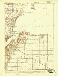
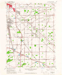
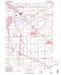
 1965 Oregon1966 Print · USGSThe industrial shoreline of Lake Erie comes alive in the mid-sixties, where the heavy rail yards of Toledo meet the growing suburbs of Oregon. Trace family roots at St Ignatius Ch or locate mid-century landmarks like the Drive-in Theater and Clay High Sch.5 unique versions available
 - 1965 Map of Walbridge, 1966 Print
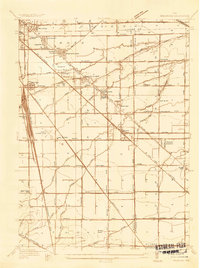
 1965 Walbridge1966 Print · USGSSoutheast of Toledo in the mid-sixties, this region reveals a massive intersection of midwestern rail lines and the maturing interstate system. Researchers can trace the layout of Walbridge, locate Lake Cem, and see the early footprint of the Toledo Airport.3 unique versions available
 - 1965 Map of Rossford, 1967 Print
 1965 Rossford1967 Print · USGSThe industrial and residential corridors of the Maumee River valley are captured here during the mid-sixties. Local researchers can trace the vast rail yards at Stanley Yard or locate landmarks like the Toledo State Hospital and Eagle Point Cem.3 unique versions available
 - 1965 Map of Toledo, 1968 Print
 1965 Toledo1968 Print · USGSToledo at the height of its mid-century development shows a landscape defined by the Maumee River and a massive rail network. Genealogists can trace family roots through neighborhood schools like DeVilbiss High Sch and find resting places in Woodlawn Cemetery.4 unique versions available
 - 1967 Map of Reno Beach, 1968 Print
 1967 Reno Beach1968 Print · USGSThe Lake Erie shoreline and Jerusalem township marshlands are captured here in the late sixties as the region balanced lakefront living with conservation. Genealogists and researchers can trace local families near Bono, Yondota, and community hubs like Township Sch and St Lukes Ch.
 - 1986 Map of Toledo
 1986 Toledo1986 Print · USGSGreater Toledo and the Lake Erie shoreline are captured here in the mid-eighties, showcasing a massive network of industrial waterways and rail lines. You can trace the path of the Maumee River past Rossford or explore the conservation lands at Ottawa National Wildlife Refuge.2 unique versions available
 - 1994 Map of Walbridge, 1998 Print
 1994 Walbridge1998 Print · USGSWood County and Lucas County geography in the 1990s reveals a landscape shaped by massive rail yards and the Ohio Turnpike. Trace local history at Millbury, Zion Ch, and the extensive Walbridge Yard during this era of regional growth.
Showing maps 1-25 of 50
Top cities near Oregon
- Toledo historical maps
- Bedford Township historical maps
- Perrysburg historical maps
- Monroe historical maps
- Monroe Charter Township historical maps
- Maumee historical maps
See more
Top neighborhoods of Oregon
- Yorktown Village historical maps
- Delta Addition historical maps
- East Meadow historical maps
- Foxgate historical maps
- Hallschild historical maps
- Heritage Estates historical maps
See more
Frequently asked questions
- What are the different types of historical maps available for Oregon?
- What is the oldest map of Oregon?
- Where can I purchase historical maps of Oregon for my home or office?
- Where can I download high-res historical maps of Oregon?
- Are there historical topographic maps available for Oregon?
- Is there historical aerial imagery available for Oregon?
- Where are historical maps of Oregon sourced from?