1930s Maps of Richfield Center, Ohio
Explore 2 historic maps of Richfield Center from the 1930s. These maps offer a rare glimpse into what life looked like during the 1930s — showing old roads, neighborhoods, homes, and landmarks that have changed or disappeared over time.
Whether you're researching your family's past, planning a metal detecting trip, or studying how Richfield Center's landscape evolved across the 1930s, these high-resolution maps are a powerful tool for exploring the history of this region.
- Focus on a specific era: All maps on this page are from the 1930s, giving you a focused view of this time period.
- See what’s changed: Compare century-old streets, trails, and buildings to today's modern landscape using overlays and satellite layers.
- Research with precision: Use these maps for genealogy, historical research, land use analysis, or educational projects.
- View, download, or print: Maps are fully viewable online in high resolution, and can be downloaded or printed for your own records.
Start exploring Richfield Center's history through authentic maps from the 1930s. This is your window into the past.
Richfield Center, OH maps
(2)- 1935 Map of Berkey
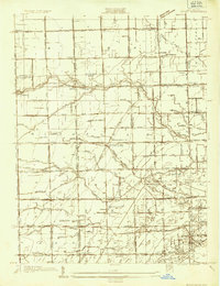 1935 Berkey1935 Print · USGSLucas County farms and small crossroads settlements are captured here in the mid-1930s as the region transitioned from electric rail to highway travel. Researchers can trace family sites near Wolfinger Cem, the St Elizabeth Sch Richfield Center, and the industrial spur at Allen Junction.
 - 1939 Map of Berkey
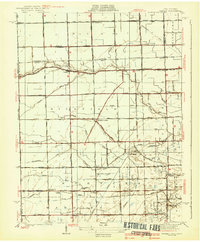 1939 Berkey1939 Print · USGSNorthwest Ohio at the end of the Depression reveals a landscape defined by rail transit and reclaimed wetlands. Trace the path of the Toledo and Western Railroad or locate family roots near Richfield Center and the Immaculate Conception Sch.3 unique versions available
End of results
Showing maps 1-2 of 2
Top cities near Richfield Center
- Toledo historical maps
- Bedford Township historical maps
- Perrysburg historical maps
- Adrian historical maps
- Sylvania historical maps
- Maumee historical maps
See more
Frequently asked questions
- What are the different types of historical maps available for Richfield Center?
- What is the oldest map of Richfield Center?
- Where can I purchase historical maps of Richfield Center for my home or office?
- Where can I download high-res historical maps of Richfield Center?
- Are there historical topographic maps available for Richfield Center?
- Is there historical aerial imagery available for Richfield Center?
- Where are historical maps of Richfield Center sourced from?