1960s Maps of Chatham Township, Ohio
Explore 6 historic maps of Chatham Township from the 1960s. These maps offer a rare glimpse into what life looked like during the 1960s — showing old roads, neighborhoods, homes, and landmarks that have changed or disappeared over time.
Whether you're researching your family's past, planning a metal detecting trip, or studying how Chatham Township's landscape evolved across the 1960s, these high-resolution maps are a powerful tool for exploring the history of this region.
- Focus on a specific era: All maps on this page are from the 1960s, giving you a focused view of this time period.
- See what’s changed: Compare century-old streets, trails, and buildings to today's modern landscape using overlays and satellite layers.
- Research with precision: Use these maps for genealogy, historical research, land use analysis, or educational projects.
- View, download, or print: Maps are fully viewable online in high resolution, and can be downloaded or printed for your own records.
Start exploring Chatham Township's history through authentic maps from the 1960s. This is your window into the past.
Chatham Township, OH maps
(6)- 1960 Map of Lagrange, 1963 Print
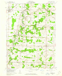 1960 Lagrange1963 Print · USGSSouthern Lorain County was a landscape of rail crossings and oil derricks in the early sixties. Researchers can trace family history at Knowles Cem, locate the Preston Oil Field, and follow the New York Central through Lagrange.2 unique versions available
 - 1961 Map of Toledo
 1961 Toledo1961 Print · USGSThe western basin of Lake Erie and the industrial heart of Northern Ohio are captured here during the post-war era. Researchers can trace historical rail lines like the New York Central or locate landmarks like the Erie Ordnance Depot and Pelee Island.
 - 1961 Map of Leroy, 1963 Print
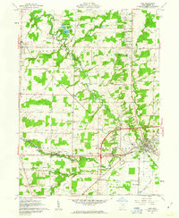
 1961 Leroy1963 Print · USGSMedina County is captured in the early sixties during a period of transition between its agricultural roots and its role as a lakeside destination. Genealogists can trace family plots at Friendsville Cem or explore the rail-linked economies of Lodi and Seville.3 unique versions available
 - 1961 Map of Lodi, 1963 Print
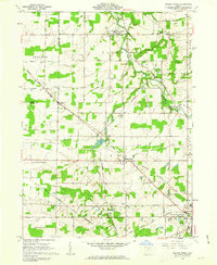
 1961 Lodi1963 Print · USGSMedina County is captured in the early sixties as a network of rail-side villages and rural crossroads communities. Trace the vanished footprints of old farmsteads through family burial grounds like Vanderhoef Cem and crossroads like Garden Isle or Esselburn.3 unique versions available
 - 1961 Map of Mallet Creek, 1963 Print
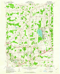
 1961 Mallet Creek1963 Print · USGSMedina County agriculture and rail industry meet in the early sixties at the junction of two major lines. Researchers can trace family roots through the York Cem and Branch Cem or locate the old Liverpool Sch and Buckeye High Sch.4 unique versions available
 - 1962 Map of Cleveland
 1962 Cleveland1962 Print · USGSNortheast Ohio and the Pennsylvania borderlands appear here during the industrial peak of the early sixties. Genealogists and historians can trace the expansive rail lines of the Nickel Plate Road and the growth of suburbs from Parma to Lyndhurst.
End of results
Showing maps 1-6 of 6
Top cities near Chatham Township
- Strongsville historical maps
- Brunswick historical maps
- Medina historical maps
- Ashland historical maps
- Oberlin historical maps
- Rittman historical maps
See more
Top neighborhoods of Chatham Township
Frequently asked questions
- What are the different types of historical maps available for Chatham Township?
- What is the oldest map of Chatham Township?
- Where can I purchase historical maps of Chatham Township for my home or office?
- Where can I download high-res historical maps of Chatham Township?
- Are there historical topographic maps available for Chatham Township?
- Is there historical aerial imagery available for Chatham Township?
- Where are historical maps of Chatham Township sourced from?