1960s Maps of Huber Heights, Ohio
Explore 3 historic maps of Huber Heights from the 1960s. These maps offer a rare glimpse into what life looked like during the 1960s — showing old roads, neighborhoods, homes, and landmarks that have changed or disappeared over time.
Whether you're researching your family's past, planning a metal detecting trip, or studying how Huber Heights's landscape evolved across the 1960s, these high-resolution maps are a powerful tool for exploring the history of this region.
- Focus on a specific era: All maps on this page are from the 1960s, giving you a focused view of this time period.
- See what’s changed: Compare century-old streets, trails, and buildings to today's modern landscape using overlays and satellite layers.
- Research with precision: Use these maps for genealogy, historical research, land use analysis, or educational projects.
- View, download, or print: Maps are fully viewable online in high resolution, and can be downloaded or printed for your own records.
Start exploring Huber Heights's history through authentic maps from the 1960s. This is your window into the past.
Huber Heights, OH maps
(3)- 1965 Map of Dayton North, 1967 Print
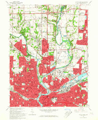 1965 Dayton North1967 Print · USGSDayton and its northern suburbs underwent rapid mid-century growth where the Great Miami and Mad Rivers meet. Researchers can trace the development of Huber Heights, locate the Siena Sisters of Mercy Rest Home, or find early sites like Poplar Hill Cem.5 unique versions available
 - 1965 Map of Tipp City, 1967 Print
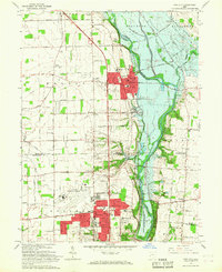 1965 Tipp City1967 Print · USGSMiami County's river valley transition is captured here in the mid-sixties as Vandalia and Tipp City expand toward the Dayton Municipal Airport. Researchers can trace old family landmarks and rural hubs like Pearson Cem, Ginghamsburg, and the Middle District Sch.4 unique versions available
 - 1965 Map of Fairborn, 1967 Print
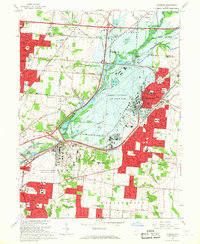 1965 Fairborn1967 Print · USGSThe Dayton suburbs and Fairborn area undergo rapid postwar expansion during the mid-sixties, centered on the massive Wright-Patterson Air Force Base. Researchers can trace the early layout of Wright State University and vanished rail stops along the Erie Lackawanna.6 unique versions available
End of results
Showing maps 1-3 of 3
Top cities near Huber Heights
- Dayton historical maps
- Kettering historical maps
- Beavercreek historical maps
- Fairborn historical maps
- Trotwood historical maps
- Xenia historical maps
See more
Top neighborhoods of Huber Heights
Frequently asked questions
- What are the different types of historical maps available for Huber Heights?
- What is the oldest map of Huber Heights?
- Where can I purchase historical maps of Huber Heights for my home or office?
- Where can I download high-res historical maps of Huber Heights?
- Are there historical topographic maps available for Huber Heights?
- Is there historical aerial imagery available for Huber Heights?
- Where are historical maps of Huber Heights sourced from?