1910s Maps of Caldwell, Ohio
Explore 3 historic maps of Caldwell from the 1910s. These maps offer a rare glimpse into what life looked like during the 1910s — showing old roads, neighborhoods, homes, and landmarks that have changed or disappeared over time.
Whether you're researching your family's past, planning a metal detecting trip, or studying how Caldwell's landscape evolved across the 1910s, these high-resolution maps are a powerful tool for exploring the history of this region.
- Focus on a specific era: All maps on this page are from the 1910s, giving you a focused view of this time period.
- See what’s changed: Compare century-old streets, trails, and buildings to today's modern landscape using overlays and satellite layers.
- Research with precision: Use these maps for genealogy, historical research, land use analysis, or educational projects.
- View, download, or print: Maps are fully viewable online in high resolution, and can be downloaded or printed for your own records.
Start exploring Caldwell's history through authentic maps from the 1910s. This is your window into the past.
Caldwell, OH maps
(3)- 1911 Map of Cumberland, 1939 Print
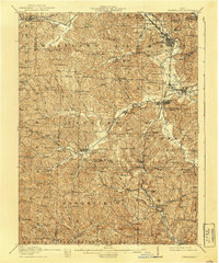 1911 Cumberland1939 Print · USGSSoutheastern Ohio at the start of the twentieth century was a landscape of ridge-top schools and valley rail junctions. Genealogists can trace family footprints through dozens of rural landmarks like Goshen Church, Dogtown, and the Rough and Ready School.2 unique versions available
 - 1911 Map of Summerfield, 1942 Print
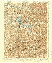 1911 Summerfield1942 Print · USGSSoutheast Ohio’s rural landscape is captured here during a time of peak settlement, showing the region's dense network of family-named ridges and valley farms. Genealogists can trace local roots through numerous landmarks like Richland Church, Kings Mine, and the Science Hill School.
 - 1912 Map of Caldwell, 1943 Print
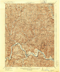 1912 Caldwell1943 Print · USGSSoutheast Ohio's river valleys and ridge-top settlements are captured here in the years before the Great War. Genealogists can trace family footprints across dozens of rural landmarks, from Manchester Church to the curiously named Poochville School and Valleyburg Woodgrove PO.
End of results
Showing maps 1-3 of 3
Top cities near Caldwell
- Waterford historical maps
- Byesville historical maps
- Beverly historical maps
- Lowell historical maps
- Quaker City historical maps
- Senecaville historical maps
See more
Frequently asked questions
- What are the different types of historical maps available for Caldwell?
- What is the oldest map of Caldwell?
- Where can I purchase historical maps of Caldwell for my home or office?
- Where can I download high-res historical maps of Caldwell?
- Are there historical topographic maps available for Caldwell?
- Is there historical aerial imagery available for Caldwell?
- Where are historical maps of Caldwell sourced from?