1990s Maps of Caldwell, Ohio
Explore 4 historic maps of Caldwell from the 1990s. These maps offer a rare glimpse into what life looked like during the 1990s — showing old roads, neighborhoods, homes, and landmarks that have changed or disappeared over time.
Whether you're researching your family's past, planning a metal detecting trip, or studying how Caldwell's landscape evolved across the 1990s, these high-resolution maps are a powerful tool for exploring the history of this region.
- Focus on a specific era: All maps on this page are from the 1990s, giving you a focused view of this time period.
- See what’s changed: Compare century-old streets, trails, and buildings to today's modern landscape using overlays and satellite layers.
- Research with precision: Use these maps for genealogy, historical research, land use analysis, or educational projects.
- View, download, or print: Maps are fully viewable online in high resolution, and can be downloaded or printed for your own records.
Start exploring Caldwell's history through authentic maps from the 1990s. This is your window into the past.
Caldwell, OH maps
(4)- 1994 Map of Macksburg, 1998 Print
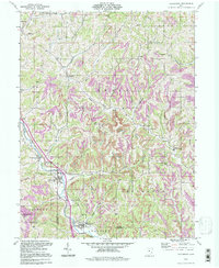 1994 Macksburg1998 Print · USGSSoutheastern Ohio’s ridge-and-valley landscape is documented here in the 1990s as the communities of the Noble and Washington county border maintained their rural character. Researchers can pinpoint several family burial sites like Hesson Cem and Rado Cem or trace the early paths through South Olive and Middleburg.
 - 1994 Map of Caldwell South, 1998 Print
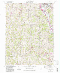 1994 Caldwell South1998 Print · USGSSoutheastern Ohio's Noble and Morgan Counties show a landscape shaped by coal mining and rail transport in the mid-1990s. Genealogists and historians can locate numerous rural burial sites like Sailor Cem and Swickard Cem alongside the CONRAIL corridor.
 - 1994 Map of Sarahsville, 1998 Print
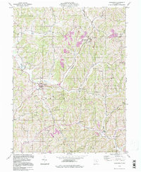 1994 Sarahsville1998 Print · USGSNoble County's ridge-and-hollow landscape in the late twentieth century reveals a community deeply tied to its geography and resource extraction. Genealogists can trace family roots through landmarks like Archer Cem, Green Valley Ch, and the small settlement of Mt Ephraim.
 - 1994 Map of Caldwell North, 1998 Print
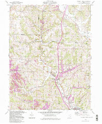 1994 Caldwell North1998 Print · USGSSoutheast Ohio’s rural and industrial character is preserved here in the late twentieth century, before further changes altered the landscape. Researchers can trace old family sites and mining operations near Belle Valley, Hoskinsville, and the McElroy Cem.
End of results
Showing maps 1-4 of 4
Top cities near Caldwell
- Waterford historical maps
- Byesville historical maps
- Beverly historical maps
- Lowell historical maps
- Quaker City historical maps
- Senecaville historical maps
See more
Frequently asked questions
- What are the different types of historical maps available for Caldwell?
- What is the oldest map of Caldwell?
- Where can I purchase historical maps of Caldwell for my home or office?
- Where can I download high-res historical maps of Caldwell?
- Are there historical topographic maps available for Caldwell?
- Is there historical aerial imagery available for Caldwell?
- Where are historical maps of Caldwell sourced from?