1960s Maps of Caldwell, Ohio
Explore 5 historic maps of Caldwell from the 1960s. These maps offer a rare glimpse into what life looked like during the 1960s — showing old roads, neighborhoods, homes, and landmarks that have changed or disappeared over time.
Whether you're researching your family's past, planning a metal detecting trip, or studying how Caldwell's landscape evolved across the 1960s, these high-resolution maps are a powerful tool for exploring the history of this region.
- Focus on a specific era: All maps on this page are from the 1960s, giving you a focused view of this time period.
- See what’s changed: Compare century-old streets, trails, and buildings to today's modern landscape using overlays and satellite layers.
- Research with precision: Use these maps for genealogy, historical research, land use analysis, or educational projects.
- View, download, or print: Maps are fully viewable online in high resolution, and can be downloaded or printed for your own records.
Start exploring Caldwell's history through authentic maps from the 1960s. This is your window into the past.
Caldwell, OH maps
(5)- 1961 Map of Clarksburg
 1961 Clarksburg1961 Print · USGSThe mid-century industrial and river landscapes of West Virginia and Ohio are detailed here, centered on the Ohio River. Researchers can trace the Baltimore and Ohio rail lines connecting towns like Parkersburg, Clarksburg, and Monongah.
 - 1961 Map of Caldwell South, 1962 Print
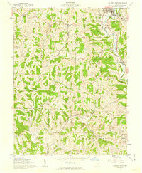 1961 Caldwell South1962 Print · USGSNoble County in the early sixties is captured here as a landscape of ridge-top cemeteries and deep-valley stream forks. Genealogists and historians can trace family locations near Olive Green and Centerville, or locate rural landmarks like Manchester Ch and Tillsonville Cem.3 unique versions available
 - 1961 Map of Sarahsville, 1963 Print
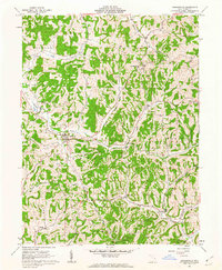 1961 Sarahsville1963 Print · USGSNoble County hill country in the early sixties shows a landscape of ridge-top villages and emerging coal extraction. Trace family roots at Pleasant Hill Ch, Mt Ephraim, and the Beatty Cem amidst the winding creeks.2 unique versions available
 - 1961 Map of Caldwell North, 1963 Print
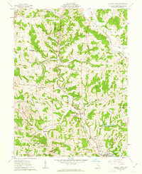 1961 Caldwell North1963 Print · USGSCentral Noble County in the early sixties reveals a landscape of coal-hauling rail lines and creek-bottom settlements. Genealogists can trace family landmarks like McElroy Cemetery, the community at Hiramsburg, and rural landmarks such as Clarks Chapel.3 unique versions available
 - 1961 Map of Macksburg, 1963 Print
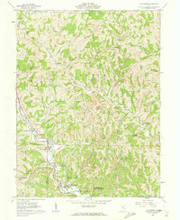 1961 Macksburg1963 Print · USGSThe Noble and Washington county borderlands are captured here in the early sixties, showing a landscape defined by deep valleys and upland mining. Researchers can trace the PENNSYLVANIA rail line through Dexter City, locate family plots at Harris Cem, or find the rural Ogles Ridge Ch.3 unique versions available
End of results
Showing maps 1-5 of 5
Top cities near Caldwell
- Waterford historical maps
- Byesville historical maps
- Beverly historical maps
- Lowell historical maps
- Quaker City historical maps
- Senecaville historical maps
See more
Frequently asked questions
- What are the different types of historical maps available for Caldwell?
- What is the oldest map of Caldwell?
- Where can I purchase historical maps of Caldwell for my home or office?
- Where can I download high-res historical maps of Caldwell?
- Are there historical topographic maps available for Caldwell?
- Is there historical aerial imagery available for Caldwell?
- Where are historical maps of Caldwell sourced from?