1940s Maps of Paulding County, Ohio
Explore 4 historic maps of Paulding County from the 1940s. These maps offer a rare glimpse into what life looked like during the 1940s — showing old roads, neighborhoods, homes, and landmarks that have changed or disappeared over time.
Whether you're researching your family's past, planning a metal detecting trip, or studying how Paulding County's landscape evolved across the 1940s, these high-resolution maps are a powerful tool for exploring the history of this region.
- Focus on a specific era: All maps on this page are from the 1940s, giving you a focused view of this time period.
- See what’s changed: Compare century-old streets, trails, and buildings to today's modern landscape using overlays and satellite layers.
- Research with precision: Use these maps for genealogy, historical research, land use analysis, or educational projects.
- View, download, or print: Maps are fully viewable online in high resolution, and can be downloaded or printed for your own records.
Start exploring Paulding County's history through authentic maps from the 1940s. This is your window into the past.
Paulding County, OH maps
(4)- 1943 Map of Bryan
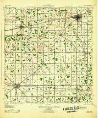 1943 Bryan1943 Print · USGSNorthwest Ohio during the mid-century is captured here as a landscape of grid-roads, small hamlets, and heavy rail traffic. Genealogists and local historians can trace family roots through numerous rural landmarks like Bethel Ch, Bratton Sch, and the hamlet of Farmer.
 - 1944 Map of Delphos
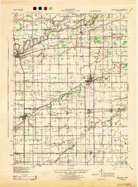
 1944 Delphos1944 Print · USGSThe rail-and-river landscape of West-Central Ohio is captured here during the mid-forties, showing the intersection of three counties. Genealogists can locate family roots via dozen of named schools like Raabe Sch and churches such as Morris Chapel or the Mennonite Cem.
 - 1944 Map of Van Wert
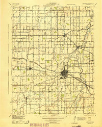
 1944 Van Wert1944 Print · USGSVan Wert County was a bustling rail and road nexus during the 1940s, centered on the intersection of the Pennsylvania Railroad and Lincoln Highway. Researchers can trace dozens of local landmarks from Willshire to Scott, including numerous rural schoolhouses like Gunsett Sch and country parishes like Asbury Ch.
 - 1944 Map of Paulding
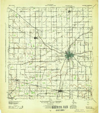
 1944 Paulding1944 Print · USGSPaulding County is captured here in the mid-forties, showing a landscape of small farm towns and a remarkable concentration of rural schoolhouses. Genealogists can trace family roots through sites like Swamp College, Cecil, and Hardesty Sch along the Wabash RR.
End of results
Showing maps 1-4 of 4
Top cities of Paulding County
- Paulding historical maps
- Antwerp historical maps
- Payne historical maps
- Oakwood historical maps
- Grover Hill historical maps
- Melrose historical maps
See more
Frequently asked questions
- What are the different types of historical maps available for Paulding County?
- What is the oldest map of Paulding County?
- Where can I purchase historical maps of Paulding County for my home or office?
- Where can I download high-res historical maps of Paulding County?
- Are there historical topographic maps available for Paulding County?
- Is there historical aerial imagery available for Paulding County?
- Where are historical maps of Paulding County sourced from?