1910s Maps of Paulding County, Ohio
Explore 4 historic maps of Paulding County from the 1910s. These maps offer a rare glimpse into what life looked like during the 1910s — showing old roads, neighborhoods, homes, and landmarks that have changed or disappeared over time.
Whether you're researching your family's past, planning a metal detecting trip, or studying how Paulding County's landscape evolved across the 1910s, these high-resolution maps are a powerful tool for exploring the history of this region.
- Focus on a specific era: All maps on this page are from the 1910s, giving you a focused view of this time period.
- See what’s changed: Compare century-old streets, trails, and buildings to today's modern landscape using overlays and satellite layers.
- Research with precision: Use these maps for genealogy, historical research, land use analysis, or educational projects.
- View, download, or print: Maps are fully viewable online in high resolution, and can be downloaded or printed for your own records.
Start exploring Paulding County's history through authentic maps from the 1910s. This is your window into the past.
Paulding County, OH maps
(4)- 1911 Map of Delphos, 1942 Print
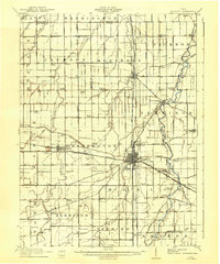 1911 Delphos1942 Print · USGSNorthwest Ohio at the height of the steam and electric rail era shows a landscape deeply organized by section lines and turnpikes. Genealogists can trace rural family life through dozens of named sites like Eickholt School, Horeb Church, and the town of Landeck.
 - 1914 Map of Van Wert, 1942 Print
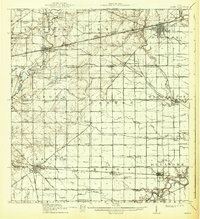
 1914 Van Wert1942 Print · USGSWestern Ohio’s agricultural heartland is documented here just before the First World War, when electric interurban lines still connected rural townships. Genealogists can locate named local landmarks like Sugar Grove Church, Wolfcale School, and the village of Venedocia.
 - 1914 Map of Bryan, 1942 Print
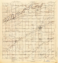
 1914 Bryan1942 Print · USGSNorthwest Ohio at the height of the steam era reveals a landscape of thriving rail towns and dense country school districts. Researchers can trace the original routes of the Wabash RR and Electric R R through Bryan and Hicksville, while locating vanished rural sites like Crazy School and Ziegler.
 - 1914 Map of Paulding, 1942 Print
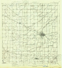
 1914 Paulding1942 Print · USGSNorthwest Ohio at the height of the railroad era reveals a landscape defined by the Maumee River and the legacy of the Wabash Canal. Genealogists and historians can trace numerous rural schoolhouses like Champion School and vanished rail stops at Knoxdale or Briceton.2 unique versions available
End of results
Showing maps 1-4 of 4
Top cities of Paulding County
- Paulding historical maps
- Antwerp historical maps
- Payne historical maps
- Oakwood historical maps
- Grover Hill historical maps
- Melrose historical maps
See more
Frequently asked questions
- What are the different types of historical maps available for Paulding County?
- What is the oldest map of Paulding County?
- Where can I purchase historical maps of Paulding County for my home or office?
- Where can I download high-res historical maps of Paulding County?
- Are there historical topographic maps available for Paulding County?
- Is there historical aerial imagery available for Paulding County?
- Where are historical maps of Paulding County sourced from?