2000-2009 Maps of South Webster, Ohio
Explore 1 historic maps of South Webster from 2000-2009. These maps offer a rare glimpse into what life looked like during the 2000s — showing old roads, neighborhoods, homes, and landmarks that have changed or disappeared over time.
Whether you're researching your family's past, planning a metal detecting trip, or studying how South Webster's landscape evolved across the 2000s, these high-resolution maps are a powerful tool for exploring the history of this region.
- Focus on a specific era: All maps on this page are from the 2000s, giving you a focused view of this time period.
- See what’s changed: Compare century-old streets, trails, and buildings to today's modern landscape using overlays and satellite layers.
- Research with precision: Use these maps for genealogy, historical research, land use analysis, or educational projects.
- View, download, or print: Maps are fully viewable online in high resolution, and can be downloaded or printed for your own records.
Start exploring South Webster's history through authentic maps from the 2000s. This is your window into the past.
South Webster, OH maps
(1)- 2002 Map of South Webster, 2006 Print
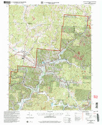 2002 South Webster2006 Print · USGSSouth Webster and its surrounding mining hills are documented in this 2002 revision. Researchers can trace family history at Bloom Switch Cem or follow the B & O Railroad past old industrial sites like Jackson Furnace and Firebrick.
End of results
Showing maps 1-1 of 1
Top cities near South Webster
- Portsmouth historical maps
- Jackson historical maps
- Lawrence historical maps
- New Boston historical maps
- Oak Hill historical maps
- Beaver historical maps
Frequently asked questions
- What are the different types of historical maps available for South Webster?
- What is the oldest map of South Webster?
- Where can I purchase historical maps of South Webster for my home or office?
- Where can I download high-res historical maps of South Webster?
- Are there historical topographic maps available for South Webster?
- Is there historical aerial imagery available for South Webster?
- Where are historical maps of South Webster sourced from?