1950s Maps of Seneca County, Ohio
Explore 8 historic maps of Seneca County from the 1950s. These maps offer a rare glimpse into what life looked like during the 1950s — showing old roads, neighborhoods, homes, and landmarks that have changed or disappeared over time.
Whether you're researching your family's past, planning a metal detecting trip, or studying how Seneca County's landscape evolved across the 1950s, these high-resolution maps are a powerful tool for exploring the history of this region.
- Focus on a specific era: All maps on this page are from the 1950s, giving you a focused view of this time period.
- See what’s changed: Compare century-old streets, trails, and buildings to today's modern landscape using overlays and satellite layers.
- Research with precision: Use these maps for genealogy, historical research, land use analysis, or educational projects.
- View, download, or print: Maps are fully viewable online in high resolution, and can be downloaded or printed for your own records.
Start exploring Seneca County's history through authentic maps from the 1950s. This is your window into the past.
Seneca County, OH maps
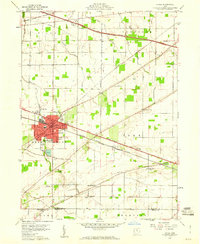
(8)- 1950 Map of Marion
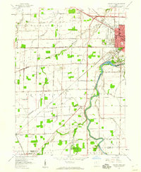
 1950 Marion1950 Print · USGSCentral Ohio was a powerhouse of rail and river industry at the mid-century point, serving as a vital corridor between the Great Lakes and the Ohio River valley. Genealogists and rail historians can trace the paths of the Erie RR and Nickel Plate Road through towns like Bucyrus, Galion, and Upper Sandusky.
 - 1956 Map of Toledo, 1968 Print
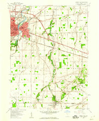
 1956 Toledo1968 Print · USGSNorthwest Ohio and the Lake Erie shoreline are shown in detail during the late fifties, showcasing a landscape of heavy industry, railroads, and island communities. Genealogists and historians can trace rail networks like the Chesapeake & Ohio RR or locate landmarks such as the Erie Proving Ground and Kelleys Island.4 unique versions available
 - 1958 Map of Fremont West, 1960 Print
 1958 Fremont West1960 Print · USGSThe western outskirts of Fremont and the Sandusky River valley are documented here in the late fifties, showcasing a landscape of active oil fields and river crossings. Researchers can trace family history through several rural burial grounds like Hite Cem or locate the Mull Covered Bridge and St Marys Ch.
 - 1958 Map of Fremont East, 1960 Print
 1958 Fremont East1960 Print · USGSThe Sandusky River valley and the city of Fremont are captured in the late fifties as they grow alongside major rail and highway corridors. Genealogists can locate family landmarks like McGormley Cemetery, the St Francis of Oak Ridge Hospital, and the Old Indian Treaty Boundary.
 - 1958 Map of Bradner, 1960 Print
 1958 Bradner1960 Print · USGSMid-century Wood County and Sandusky County thrive along a busy rail corridor in the late fifties. Researchers can trace the extensive network of Oil Wells around Bradner and locate family-history landmarks like the Graham Cem and Township Sch.
 - 1959 Map of Bellevue, 1960 Print
 1959 Bellevue1960 Print · USGSBellevue stands at the four-county junction of Erie, Huron, Sandusky, and Seneca during the late 1950s expansion. Genealogists and local historians can trace school locations like Ridge Sch and Shumaker Sch alongside the tracks of the Pennsylvania RR.
 - 1959 Map of Clyde, 1960 Print
 1959 Clyde1960 Print · USGSSandusky County is shown here in the late fifties as a bustling rail and highway corridor focused on the hub of Clyde. Genealogists and local historians can trace family plots and rural landmarks at McPherson Cemetery, Mt Carmel Cem, and York Free Chapel.
 - 1959 Map of Helena, 1960 Print
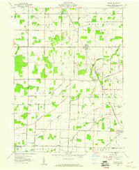 1959 Helena1960 Print · USGSSandusky County's rural landscape at the close of the 1950s shows a productive mix of agriculture and oil production. Researchers can locate family landmarks like St Marys Cem and Smith Cem, or trace the rail lines through Helena and Burgoon.2 unique versions available
End of results
Showing maps 1-8 of 8
Top cities of Seneca County
Frequently asked questions
- What are the different types of historical maps available for Seneca County?
- What is the oldest map of Seneca County?
- Where can I purchase historical maps of Seneca County for my home or office?
- Where can I download high-res historical maps of Seneca County?
- Are there historical topographic maps available for Seneca County?
- Is there historical aerial imagery available for Seneca County?
- Where are historical maps of Seneca County sourced from?