Old Maps of Seneca County, Ohio for Genealogy
Trace your family roots with 175 historic maps of Seneca County. These high-res maps reveal old neighborhoods, homesites, landmarks, and streets — helping you uncover where your ancestors lived and how the area evolved over time.
- Explore historic neighborhoods: Identify where your relatives may have lived in the 1800s or 1900s.
- Compare maps over time: Trace the changes in streets, buildings, and landmarks for multi-generational research.
- Perfect for genealogy & ancestry research: Used by family historians and researchers to map out lineage and migration.
These maps are an incredible resource for exploring your personal connection to Seneca County's past.
Seneca County, OH maps
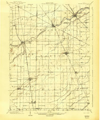
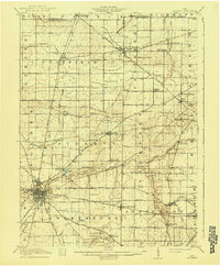
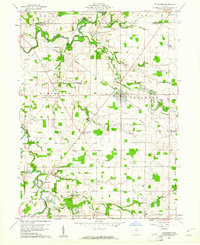
(175)- 1901 Map of Bellevue, 1958 Print
 1901 Bellevue1958 Print · USGSAcross the marshy lowlands and limestone springs of Erie and Sandusky counties at the turn of the century, a massive railroad network dominates the landscape. Genealogists can trace family footprints in Clyde and Bellevue or locate vanished rail stops at Thames and Parkertown.
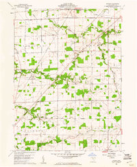
 - 1901 Map of Fostoria, 1958 Print
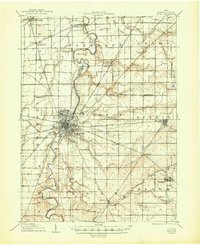
 1901 Fostoria1958 Print · USGSNorthwest Ohio at the turn of the century is captured here as a thriving rail hub where three counties meet. Genealogists and rail historians can trace the early networks of Fostoria and locate long-standing settlements like New Riegel, Alvada, and Bascom.
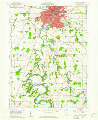
 - 1901 Map of Fremont, 1961 Print
 1901 Fremont1961 Print · USGSSandusky County at the dawn of the twentieth century is a bustling corridor of steam and electric rail lines. Trace the industrial footprint of Fremont and locate vanished rural junctions like Kingsway, Havens, and the Seneca Indian Reservation.
 - 1901 Map of Elmore, 1961 Print
 1901 Elmore1961 Print · USGSNorthwest Ohio at the turn of the century was a landscape of thriving rail towns and fertile township acreage. You can trace the path of the Lake Shore Electric Railway through Woodville or locate early settlements like Pemberville and Rising Sun.
 - 1903 Map of Bellevue
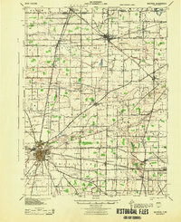
 1903 Bellevue1903 Print · USGSNear the dawn of the twentieth century, the junction of Erie and Sandusky counties was a bustling corridor of rail and water transport. Genealogists and historians can trace the early footprints of Bellevue and Clyde, or find specific local landmarks like the Blue Hole and the Connecticut Western Reserve Boundary Line.5 unique versions available
 - 1903 Map of Fremont, 1934 Print
 1903 Fremont1934 Print · USGSNorthwest Ohio at the turn of the century was a bustling intersection of heavy rail and river commerce centered on the Sandusky River. Researchers can trace the early footprints of Fremont and Green Spring or locate smaller stops along the Wheeling and Lake Erie and the electric line to Ballville.2 unique versions available
 - 1903 Map of Fostoria, 1939 Print
 1903 Fostoria1939 Print · USGSFostoria at the turn of the century was a burgeoning rail center where seven major lines crossed paths at a triple-county border. Genealogists can trace family footprints in small outlying settlements like New Riegel, Bascom, and West Independence or follow the path of the Hocking Valley RR.
 - 1903 Map of Elmore, 1943 Print
 1903 Elmore1943 Print · USGSNorthwest Ohio at the turn of the century was a hive of competing rail lines and riverside market towns. Researchers can trace the early industrial footprints of Gibsonburg, Pemberville, and Elmore alongside the Ohio Central System and Wolf Creek.
 - 1906 Map of Sycamore, 1932 Print
 1906 Sycamore1932 Print · USGSThe rural heart of north-central Ohio is captured here at the height of its steam-rail era. Genealogists and local historians can trace family locations near Sycamore, Nevada, and Belle Vernon, or locate landmarks like Oakgrove School and the Rock Run Church.
 - 1906 Map of Tiffin, 1948 Print
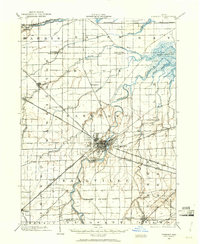
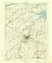
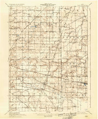
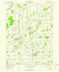
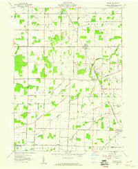
 1906 Tiffin1948 Print · USGSSeneca County's rail-and-river network is frozen in time during the first decade of the 1900s. Genealogists can trace family roots through vanished stops like Linden or follow the Seneca Indian Reservation Boundary past Tiffin and Bloomville.
 - 1907 Map of Upper Sandusky, 1943 Print
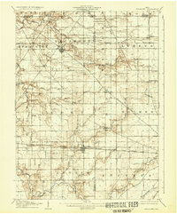
 1907 Upper Sandusky1943 Print · USGSWyandot County at the dawn of the twentieth century was a landscape of thriving rail junctions and dispersed rural school districts. Genealogists and local historians can trace the exact locations of family landmarks like Grace Chapel, the Indian Mill, and numerous rural schools from Moody School to Hendricks School 24.
 - 1915 Map of Siam, 1936 Print
 1915 Siam1936 Print · USGSThe Seneca and Huron county borderlands are shown here in the years following the turn of the century as railroads and drainage projects transformed the landscape. Researchers can trace the legacy of small communities and rural education at Siam, Attica Junction, and the Podunk School.2 unique versions available
 - 1915 Map of Bucyrus, 1940 Print
 1915 Bucyrus1940 Print · USGSBucyrus and the surrounding Crawford County plains are captured here at the height of the steam-and-electric rail era. Genealogists can locate rural landmarks like the COUNTY INFIRMARY, trace family plots near Leesville, or find vanished schoolhouses like Muck School.
 - 1943 Map of Bucyrus
 1943 Bucyrus1943 Print · USGSCrawford County at the height of the Second World War reveals a landscape defined by busy rail junctions and rural school districts. Genealogists and historians can trace family roots through numerous numbered schoolhouses and settlements like Sulphur Springs, Tiro, and the County Infirmary.
 - 1950 Map of Marion
 1950 Marion1950 Print · USGSCentral Ohio was a powerhouse of rail and river industry at the mid-century point, serving as a vital corridor between the Great Lakes and the Ohio River valley. Genealogists and rail historians can trace the paths of the Erie RR and Nickel Plate Road through towns like Bucyrus, Galion, and Upper Sandusky.
 - 1956 Map of Toledo, 1968 Print
 1956 Toledo1968 Print · USGSNorthwest Ohio and the Lake Erie shoreline are shown in detail during the late fifties, showcasing a landscape of heavy industry, railroads, and island communities. Genealogists and historians can trace rail networks like the Chesapeake & Ohio RR or locate landmarks such as the Erie Proving Ground and Kelleys Island.4 unique versions available
 - 1958 Map of Fremont West, 1960 Print
 1958 Fremont West1960 Print · USGSThe western outskirts of Fremont and the Sandusky River valley are documented here in the late fifties, showcasing a landscape of active oil fields and river crossings. Researchers can trace family history through several rural burial grounds like Hite Cem or locate the Mull Covered Bridge and St Marys Ch.
 - 1958 Map of Fremont East, 1960 Print
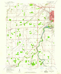
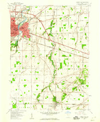 1958 Fremont East1960 Print · USGSThe Sandusky River valley and the city of Fremont are captured in the late fifties as they grow alongside major rail and highway corridors. Genealogists can locate family landmarks like McGormley Cemetery, the St Francis of Oak Ridge Hospital, and the Old Indian Treaty Boundary.
 - 1958 Map of Bradner, 1960 Print
 1958 Bradner1960 Print · USGSMid-century Wood County and Sandusky County thrive along a busy rail corridor in the late fifties. Researchers can trace the extensive network of Oil Wells around Bradner and locate family-history landmarks like the Graham Cem and Township Sch.
 - 1959 Map of Bellevue, 1960 Print
 1959 Bellevue1960 Print · USGSBellevue stands at the four-county junction of Erie, Huron, Sandusky, and Seneca during the late 1950s expansion. Genealogists and local historians can trace school locations like Ridge Sch and Shumaker Sch alongside the tracks of the Pennsylvania RR.
 - 1959 Map of Clyde, 1960 Print
 1959 Clyde1960 Print · USGSSandusky County is shown here in the late fifties as a bustling rail and highway corridor focused on the hub of Clyde. Genealogists and local historians can trace family plots and rural landmarks at McPherson Cemetery, Mt Carmel Cem, and York Free Chapel.
 - 1959 Map of Helena, 1960 Print
 1959 Helena1960 Print · USGSSandusky County's rural landscape at the close of the 1950s shows a productive mix of agriculture and oil production. Researchers can locate family landmarks like St Marys Cem and Smith Cem, or trace the rail lines through Helena and Burgoon.2 unique versions available
 - 1960 Map of Sycamore, 1961 Print
 1960 Sycamore1961 Print · USGSThe crossroads of Wyandot and Seneca Counties are captured here in 1960, showing a landscape still defined by rail lines and old treaty lines. Trace the Old Indian Treaty Boundary and find rural landmarks like Quaker Hill Cem and Parker Bridge.3 unique versions available
 - 1960 Map of Watson, 1961 Print
 1960 Watson1961 Print · USGSSeneca County's rural townships are captured in the early sixties as they balanced traditional agriculture with mid-century changes like the Tiffin Speedway. Researchers can find legacy sites including McMeen Cem, St Jacobs Ch, and the long-standing Old Indian Treaty Boundary.3 unique versions available
 - 1960 Map of Tiffin South, 1961 Print
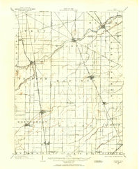
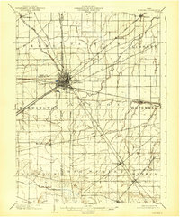
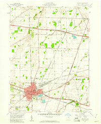
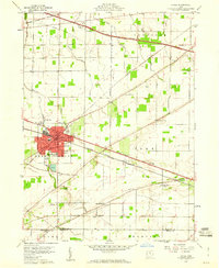
 1960 Tiffin South1961 Print · USGSTiffin was a thriving rail and educational hub in the early sixties, centered on the winding Sandusky River. Researchers can trace old family sites across HOPEWELL and EDEN townships, locating St Marys Cem, Heidelberg College, and the County Fairground.3 unique versions available
Showing maps 1-25 of 175
Top cities of Seneca County
Frequently asked questions
- What are the different types of historical maps available for Seneca County?
- What is the oldest map of Seneca County?
- Where can I purchase historical maps of Seneca County for my home or office?
- Where can I download high-res historical maps of Seneca County?
- Are there historical topographic maps available for Seneca County?
- Is there historical aerial imagery available for Seneca County?
- Where are historical maps of Seneca County sourced from?