1960s Maps of Summit County, Ohio
Explore 13 historic maps of Summit County from the 1960s. These maps offer a rare glimpse into what life looked like during the 1960s — showing old roads, neighborhoods, homes, and landmarks that have changed or disappeared over time.
Whether you're researching your family's past, planning a metal detecting trip, or studying how Summit County's landscape evolved across the 1960s, these high-resolution maps are a powerful tool for exploring the history of this region.
- Focus on a specific era: All maps on this page are from the 1960s, giving you a focused view of this time period.
- See what’s changed: Compare century-old streets, trails, and buildings to today's modern landscape using overlays and satellite layers.
- Research with precision: Use these maps for genealogy, historical research, land use analysis, or educational projects.
- View, download, or print: Maps are fully viewable online in high resolution, and can be downloaded or printed for your own records.
Start exploring Summit County's history through authentic maps from the 1960s. This is your window into the past.
Summit County, OH maps
(13)- 1962 Map of Canton
 1962 Canton1962 Print · USGSThe industrial heartland of Eastern Ohio and Western Pennsylvania thrives in the early sixties as steel mills and rail lines dominate the river valleys. Genealogists and historians can trace local landmarks like McKinley National Memorial, Malone College, and industrial sites such as Republic Steel Corp.2 unique versions available
 - 1962 Map of Cleveland
 1962 Cleveland1962 Print · USGSNortheast Ohio and the Pennsylvania borderlands appear here during the industrial peak of the early sixties. Genealogists and historians can trace the expansive rail lines of the Nickel Plate Road and the growth of suburbs from Parma to Lyndhurst.
 - 1963 Map of Twinsburg, 1964 Print
 1963 Twinsburg1964 Print · USGSNortheastern Ohio is shown in the early sixties as industrial rail corridors met growing suburban neighborhoods. Trace the grounds of the Amusement Park at Geauga Lake, find the Cleveland Boys Sch, or locate the Crown Hill Cemetery.4 unique versions available
 - 1963 Map of Northfield, 1964 Print
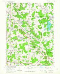
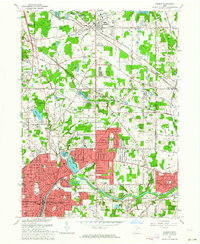
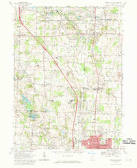
 1963 Northfield1964 Print · USGSMid-century Summit County is a mix of river valley history and burgeoning suburban life in the early sixties. Genealogists and local historians can trace family plots at All Saints Cemetery and the Northfield-Macedonia Cem, or locate landmarks like the Welcome Airport and Drive-in Theater.4 unique versions available
 - 1963 Map of Broadview Heights, 1964 Print
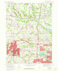
 1963 Broadview Heights1964 Print · USGSBroadview Heights and North Royalton are shown during a decade of rapid suburbanization and institutional growth. Local researchers can trace the development of the Ohio Turnpike alongside landmarks like the Veterans Administration Hospital and the Cleveland Ordnance Plant.5 unique versions available
 - 1963 Map of West Richfield, 1964 Print
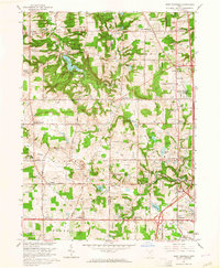 1963 West Richfield1964 Print · USGSThe Western Reserve landscape of Medina and Summit Counties was evolving quickly in the early sixties as suburban growth met rural industry. Genealogists and historians can trace family plots at Hinckley Ridge Cem or locate the site of the Cleveland Ordnance Plant.5 unique versions available
 - 1963 Map of Hudson, 1964 Print
 1963 Hudson1964 Print · USGSNortheastern Ohio’s suburban landscape comes into focus in the early sixties as the cities of the Cuyahoga Valley expand. Genealogists can locate family sites at Markillie Cem or Draper Cem, and trace the grounds of Western Reserve Academy or the quiet settlement of Darrowville.4 unique versions available
 - 1963 Map of Peninsula, 1965 Print
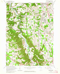
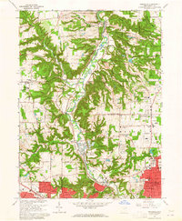 1963 Peninsula1965 Print · USGSThe Cuyahoga Valley was entering a period of suburban expansion in the early sixties while maintaining its industrial rail heritage. Traces of local history are found at Smith Chapel, Ira Cem, and the Baltimore and Ohio line through Peninsula.5 unique versions available
 - 1967 Map of Akron East, 1969 Print
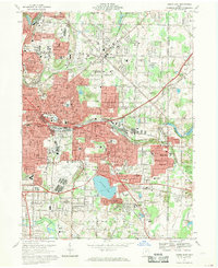 1967 Akron East1969 Print · USGSSummit County's industrial heart and growing suburbs are captured here during the late sixties. Trace the footprint of aviation history at the Goodyear Airdock and explore the rail networks of the Erie-Lackawanna RR and Penn Central.6 unique versions available
 - 1967 Map of Akron West, 1970 Print
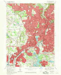 1967 Akron West1970 Print · USGSAkron and Barberton are shown in great detail during the late 1960s, a period of peak industrial and suburban development. Researchers can trace dozens of local schools and landmarks like the University of Akron Memorial Stadium, St Nicholas Ch, and Lake Anna.6 unique versions available
 - 1967 Map of North Canton, 1970 Print
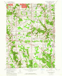
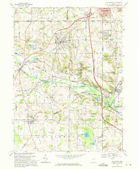
 1967 North Canton1970 Print · USGSNorth Canton and the surrounding townships of Stark and Summit counties are shown here in the late sixties as suburban development meets rural industry. Genealogists can trace family roots through Greensburg Cem, Tritts Millpond, and local landmarks like Queen of Heaven Ch.3 unique versions available
 - 1969 Map of Wadsworth, 1971 Print
 1969 Wadsworth1971 Print · USGSWestern Medina and Summit Counties are shown in the late sixties as suburban growth begins to merge old farming communities with industrial hubs. Researchers can trace the development of Wadsworth and Norton, locating vanished landmarks like the Drive-In Theater or long-standing sites like Sharon Center.2 unique versions available
 - 1969 Map of Doylestown, 1971 Print
 1969 Doylestown1971 Print · USGSNortheast Ohio's industrial and agricultural character is captured here during the late sixties as suburban growth reached toward Doylestown. Researchers can trace rural lineages through sites like Maple Grove Cem or locate the Harvey Sch and the Penn Central rail lines.2 unique versions available
End of results
Showing maps 1-13 of 13
Top cities of Summit County
- Akron historical maps
- Cuyahoga Falls historical maps
- Stow historical maps
- Green historical maps
- Barberton historical maps
- Hudson historical maps
See more
Frequently asked questions
- What are the different types of historical maps available for Summit County?
- What is the oldest map of Summit County?
- Where can I purchase historical maps of Summit County for my home or office?
- Where can I download high-res historical maps of Summit County?
- Are there historical topographic maps available for Summit County?
- Is there historical aerial imagery available for Summit County?
- Where are historical maps of Summit County sourced from?