1990s Maps of Mesopotamia Township, Ohio
Explore 6 historic maps of Mesopotamia Township from the 1990s. These maps offer a rare glimpse into what life looked like during the 1990s — showing old roads, neighborhoods, homes, and landmarks that have changed or disappeared over time.
Whether you're researching your family's past, planning a metal detecting trip, or studying how Mesopotamia Township's landscape evolved across the 1990s, these high-resolution maps are a powerful tool for exploring the history of this region.
- Focus on a specific era: All maps on this page are from the 1990s, giving you a focused view of this time period.
- See what’s changed: Compare century-old streets, trails, and buildings to today's modern landscape using overlays and satellite layers.
- Research with precision: Use these maps for genealogy, historical research, land use analysis, or educational projects.
- View, download, or print: Maps are fully viewable online in high resolution, and can be downloaded or printed for your own records.
Start exploring Mesopotamia Township's history through authentic maps from the 1990s. This is your window into the past.
Mesopotamia Township, OH maps
(6)- 1994 Map of Cleveland North
 1994 Cleveland North1994 Print · USGSThe Lake Erie shoreline in the mid-nineties shows the urban density of Northeast Ohio giving way to coastal preserves. Researchers can trace the development of lakeside towns like Eastlake and Madison while locating landmarks like Burke Lakefront Airport and Fairport Harbor.
 - 1994 Map of Cleveland South
 1994 Cleveland South1994 Print · USGSThe metropolitan corridor between Akron and Cleveland is shown here in the mid-nineties during a period of significant suburban growth. Researchers can trace the path of the Ohio Turnpike or explore expansive recreation lands like West Branch State Park.
 - 1994 Map of Windsor, 1997 Print
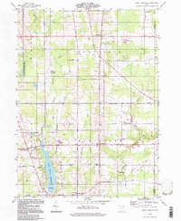
 1994 Windsor1997 Print · USGSAshtabula County remains a landscape of river-bend settlements and rural crossroads in the mid-1990s. Genealogists can locate family sites near Windsor Mills, Stoneville, or the Pioneer Cem while tracing the path of the Grand River.
 - 1994 Map of West Farmington, 1997 Print
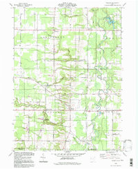
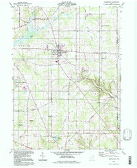
 1994 West Farmington1997 Print · USGSTrumbull County in the 1990s preserves its rural character through established crossroads and river valleys. Researchers can trace family history at Hillside Cem or locate old community centers like Mesopotamia and West Farmington.
 - 1994 Map of Middlefield, 1997 Print
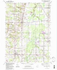
 1994 Middlefield1997 Print · USGSGeauga County’s rural townships are captured here in the mid-1990s, showing a landscape defined by headwater streams and scattered crossroads. Researchers can trace family history through sites like Burroughs Cem, the Shrine of Maria-Poch, and the old rail corridor at Burton Station.
 - 1994 Map of East Claridon, 1997 Print
 1994 East Claridon1997 Print · USGSGeauga County's rural townships and headwaters are captured here in the mid-1990s, centered on the intersection of farming life and water management. Genealogists and local historians can locate specific sites like Huntsburg Cem, the Culbertsons Corners Sch, and the unique Nassua Astronomical Sta.
End of results
Showing maps 1-6 of 6
Top cities near Mesopotamia Township
- Warren historical maps
- Howland Township historical maps
- Champion historical maps
- Champion Township historical maps
- Cortland historical maps
- Cortland historical maps
See more
Top neighborhoods of Mesopotamia Township
Frequently asked questions
- What are the different types of historical maps available for Mesopotamia Township?
- What is the oldest map of Mesopotamia Township?
- Where can I purchase historical maps of Mesopotamia Township for my home or office?
- Where can I download high-res historical maps of Mesopotamia Township?
- Are there historical topographic maps available for Mesopotamia Township?
- Is there historical aerial imagery available for Mesopotamia Township?
- Where are historical maps of Mesopotamia Township sourced from?