1990s Maps of Vienna Township, Ohio
Explore 4 historic maps of Vienna Township from the 1990s. These maps offer a rare glimpse into what life looked like during the 1990s — showing old roads, neighborhoods, homes, and landmarks that have changed or disappeared over time.
Whether you're researching your family's past, planning a metal detecting trip, or studying how Vienna Township's landscape evolved across the 1990s, these high-resolution maps are a powerful tool for exploring the history of this region.
- Focus on a specific era: All maps on this page are from the 1990s, giving you a focused view of this time period.
- See what’s changed: Compare century-old streets, trails, and buildings to today's modern landscape using overlays and satellite layers.
- Research with precision: Use these maps for genealogy, historical research, land use analysis, or educational projects.
- View, download, or print: Maps are fully viewable online in high resolution, and can be downloaded or printed for your own records.
Start exploring Vienna Township's history through authentic maps from the 1990s. This is your window into the past.
Vienna Township, OH maps
(4)- 1994 Map of Sharon West, 1997 Print
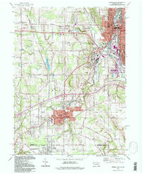 1994 Sharon West1997 Print · USGSThe industrial heart of the Shenango Valley is captured here during the 1990s, illustrating the dense rail and river networks of the Ohio-Pennsylvania state line. Researchers can trace family sites from Oakwood Cem to St Patricks Sch and the streets of Hubbard.
 - 1994 Map of Girard, 1997 Print
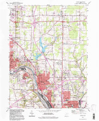 1994 Girard1997 Print · USGSThe industrial heart of the Mahoning Valley is captured here during the 1990s as the region transitioned from its steel-mill peak. Genealogists can locate family sites near Tod Homestead Cemetery, while historians trace the rail-and-river economy along the Mahoning River and Lake Girard.
 - 1994 Map of Orangeville, 1997 Print
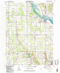 1994 Orangeville1997 Print · USGSThe Ohio-Pennsylvania state line near Orangeville is captured here in the mid-1990s, showcasing a rural landscape of creek valleys and small settlements. Researchers can trace family sites like St Marys Cemetery and local landmarks like the Sharon Speedway.
 - 1994 Map of Cortland, 1997 Print
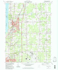 1994 Cortland1997 Print · USGSTrumbull County in the mid-nineties shows a mix of growing residential hubs and traditional Ohio crossroads. Genealogists can trace family landmarks across Sheldon Corners and several historic burial sites, including Casterline Cem and Sheldon Cem.
End of results
Showing maps 1-4 of 4
Top cities near Vienna Township
- Youngstown historical maps
- Boardman historical maps
- Warren historical maps
- Austintown historical maps
- Weathersfield Township historical maps
- Howland Township historical maps
See more
Top neighborhoods of Vienna Township
Frequently asked questions
- What are the different types of historical maps available for Vienna Township?
- What is the oldest map of Vienna Township?
- Where can I purchase historical maps of Vienna Township for my home or office?
- Where can I download high-res historical maps of Vienna Township?
- Are there historical topographic maps available for Vienna Township?
- Is there historical aerial imagery available for Vienna Township?
- Where are historical maps of Vienna Township sourced from?