1990s Maps of Orrville, Ohio
Explore 2 historic maps of Orrville from the 1990s. These maps offer a rare glimpse into what life looked like during the 1990s — showing old roads, neighborhoods, homes, and landmarks that have changed or disappeared over time.
Whether you're researching your family's past, planning a metal detecting trip, or studying how Orrville's landscape evolved across the 1990s, these high-resolution maps are a powerful tool for exploring the history of this region.
- Focus on a specific era: All maps on this page are from the 1990s, giving you a focused view of this time period.
- See what’s changed: Compare century-old streets, trails, and buildings to today's modern landscape using overlays and satellite layers.
- Research with precision: Use these maps for genealogy, historical research, land use analysis, or educational projects.
- View, download, or print: Maps are fully viewable online in high resolution, and can be downloaded or printed for your own records.
Start exploring Orrville's history through authentic maps from the 1990s. This is your window into the past.
Orrville, OH maps
(2)- 1994 Map of Orrville, 1998 Print
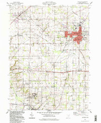 1994 Orrville1998 Print · USGSOrrville and the surrounding Wayne County farmlands are captured in the mid-1990s as the rail and agricultural economy continued to shape the region. Genealogists and local historians can trace family landmarks like Kapp Gish Cem, the Apple Creek State Development Center, and the 4 Tracks rail line.
 - 1994 Map of Dalton, 1998 Print
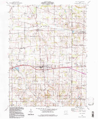 1994 Dalton1998 Print · USGSWayne and Stark Counties in the 1990s showcase a blend of established villages and persistent rural history. Trace the development of local hamlets like Burton City and East Greenville or locate family landmarks such as Sonnenberg Sch and Arnold Cem.
End of results
Showing maps 1-2 of 2
Top cities near Orrville
- Akron historical maps
- Massillon historical maps
- Wooster historical maps
- Barberton historical maps
- Wadsworth historical maps
- New Franklin historical maps
See more
Frequently asked questions
- What are the different types of historical maps available for Orrville?
- What is the oldest map of Orrville?
- Where can I purchase historical maps of Orrville for my home or office?
- Where can I download high-res historical maps of Orrville?
- Are there historical topographic maps available for Orrville?
- Is there historical aerial imagery available for Orrville?
- Where are historical maps of Orrville sourced from?