1960s Maps of Pulaski Township, Ohio
Explore 4 historic maps of Pulaski Township from the 1960s. These maps offer a rare glimpse into what life looked like during the 1960s — showing old roads, neighborhoods, homes, and landmarks that have changed or disappeared over time.
Whether you're researching your family's past, planning a metal detecting trip, or studying how Pulaski Township's landscape evolved across the 1960s, these high-resolution maps are a powerful tool for exploring the history of this region.
- Focus on a specific era: All maps on this page are from the 1960s, giving you a focused view of this time period.
- See what’s changed: Compare century-old streets, trails, and buildings to today's modern landscape using overlays and satellite layers.
- Research with precision: Use these maps for genealogy, historical research, land use analysis, or educational projects.
- View, download, or print: Maps are fully viewable online in high resolution, and can be downloaded or printed for your own records.
Start exploring Pulaski Township's history through authentic maps from the 1960s. This is your window into the past.
Pulaski Township, OH maps
(4)- 1960 Map of Evansport, 1961 Print
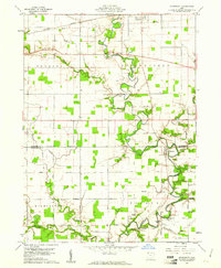 1960 Evansport1961 Print · USGSNorthwest Ohio at the dawn of the sixties shows a landscape shaped by the winding Tiffin River and the New York Central rail line. Genealogists can trace family landmarks like Evansport Cem, Oak Grove Ch, and the Township High Sch near Evansport.2 unique versions available
 - 1960 Map of Bryan, 1961 Print
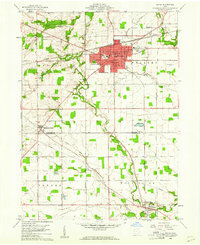 1960 Bryan1961 Print · USGSThe Northwest Ohio landscape of the early sixties comes alive around Bryan and the winding Lick Creek. Genealogists and local historians can trace rural roots through Brown Cem, Washington Sch, and the small settlement of Ney.4 unique versions available
 - 1961 Map of West Unity, 1962 Print
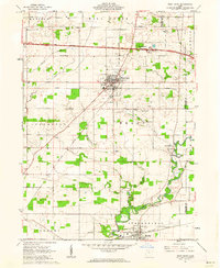 1961 West Unity1962 Print · USGSWilliams County at the start of the sixties shows a landscape defined by the Tiffin River and the new Ohio Turnpike. Researchers can trace family history at the Quaker Ch Cem or explore the rail era through West Unity and Stryker.2 unique versions available
 - 1961 Map of Montpelier, 1963 Print
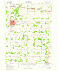 1961 Montpelier1963 Print · USGSMontpelier and the surrounding Williams County townships are shown here in the early sixties as modern turnpikes and airports began to change the rural landscape. Researchers can trace family roots at Riverside Cem, visit the County Home, or locate the West Bethesda Ch.2 unique versions available
End of results
Showing maps 1-4 of 4
Top cities near Pulaski Township
- Defiance historical maps
- Bryan historical maps
- Archbold historical maps
- Montpelier historical maps
- Edgerton historical maps
- West Unity historical maps
See more
Top neighborhoods of Pulaski Township
- Plover Lake Addition historical maps
- Bona Vesta historical maps
- McDonald Subdivision historical maps
- Sinns Subdivision historical maps
- Holly Addition historical maps
- Lakeland Woods Estates historical maps
See more
Frequently asked questions
- What are the different types of historical maps available for Pulaski Township?
- What is the oldest map of Pulaski Township?
- Where can I purchase historical maps of Pulaski Township for my home or office?
- Where can I download high-res historical maps of Pulaski Township?
- Are there historical topographic maps available for Pulaski Township?
- Is there historical aerial imagery available for Pulaski Township?
- Where are historical maps of Pulaski Township sourced from?