1900s (20th Century) Maps of Grand Rapids, Ohio
Explore 9 historic maps of Grand Rapids from the 1900s (20th Century). These maps offer a rare glimpse into what life looked like during the 1900s — showing old roads, neighborhoods, homes, and landmarks that have changed or disappeared over time.
Whether you're researching your family's past, planning a metal detecting trip, or studying how Grand Rapids's landscape evolved across the 1900s, these high-resolution maps are a powerful tool for exploring the history of this region.
- Focus on a specific era: All maps on this page are from the 1900s, giving you a focused view of this time period.
- See what’s changed: Compare century-old streets, trails, and buildings to today's modern landscape using overlays and satellite layers.
- Research with precision: Use these maps for genealogy, historical research, land use analysis, or educational projects.
- View, download, or print: Maps are fully viewable online in high resolution, and can be downloaded or printed for your own records.
Start exploring Grand Rapids's history through authentic maps from the 1900s. This is your window into the past.
Grand Rapids, OH maps
(9)- 1909 Map of Mc Clure, 1936 Print
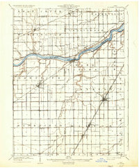 1909 Mc Clure1936 Print · USGSNorthwest Ohio's agricultural and transit heartland is captured here at the start of the twentieth century. Genealogists and rail historians can trace the paths of the Wabash RR and the Electric Detroit and Toledo Line as they connected towns like Mc Clure and Weston.2 unique versions available
 - 1935 Map of Grand Rapids
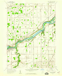
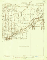 1935 Grand Rapids1935 Print · USGSLucas and Wood counties during the mid-1930s display a landscape defined by the winding Maumee River and its industrial history. Genealogists and historians can trace the foundations of local communities at St Patrick Cem, Nazareth Hall, and the Lucas Wood Co Canal.
 - 1940 Map of Grand Rapids
 1940 Grand Rapids1940 Print · USGSThe riverfront and rail lines of Wood and Lucas Counties are captured here in the years before WWII. Genealogists and historians can trace the Napoleon Canal, locate Salem Ch, and follow the Twelvemile Reservation Boundary near Grand Rapids.2 unique versions available
 - 1952 Map of Grand Rapids, 1953 Print
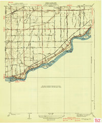
 1952 Grand Rapids1953 Print · USGSThe Maumee River valley comes alive in the early 1950s, showing a landscape shaped by river transport and deep-rooted agricultural townships. Researchers can find precise locations for Neapolis, Providence Church, and the unique Toledo Welfare Farm.
 - 1956 Map of Toledo, 1968 Print
 1956 Toledo1968 Print · USGSNorthwest Ohio and the Lake Erie shoreline are shown in detail during the late fifties, showcasing a landscape of heavy industry, railroads, and island communities. Genealogists and historians can trace rail networks like the Chesapeake & Ohio RR or locate landmarks such as the Erie Proving Ground and Kelleys Island.4 unique versions available
 - 1958 Map of Grand Rapids, 1960 Print
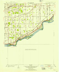
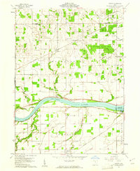
 1958 Grand Rapids1960 Print · USGSThe river and rail corridor of Wood County is shown here in the late fifties, dominated by the islands of the Maumee River. Family historians can trace local roots through the Beaver Creek Cem, Providence Ch, and the outlying County Farm.3 unique versions available
 - 1960 Map of Colton, 1961 Print
 1960 Colton1961 Print · USGSHenry County and the Maumee River valley are shown in the early 1960s as a landscape of timbered forests and precise rail-side villages. Researchers can locate family landmarks like Mohler-Union Cem, Damascus Ch, and the riverside Grand Rapids Dam.3 unique versions available
 - 1961 Map of Toledo
 1961 Toledo1961 Print · USGSThe western basin of Lake Erie and the industrial heart of Northern Ohio are captured here during the post-war era. Researchers can trace historical rail lines like the New York Central or locate landmarks like the Erie Ordnance Depot and Pelee Island.
 - 1986 Map of Findlay
 1986 Findlay1986 Print · USGSNorthwest Ohio's industrial and agricultural heartland is documented here in the mid-1980s, centered on the major hubs of Findlay, Fostoria, and Tiffin. Researchers can trace the intersections of the BALTIMORE AND OHIO railroad and family sites near Greenlawn Cem or Sagar Ridge.2 unique versions available
End of results
Showing maps 1-9 of 9
Top cities near Grand Rapids
- Toledo historical maps
- Bowling Green historical maps
- Perrysburg historical maps
- Maumee historical maps
- Napoleon historical maps
- Monclova historical maps
See more
Frequently asked questions
- What are the different types of historical maps available for Grand Rapids?
- What is the oldest map of Grand Rapids?
- Where can I purchase historical maps of Grand Rapids for my home or office?
- Where can I download high-res historical maps of Grand Rapids?
- Are there historical topographic maps available for Grand Rapids?
- Is there historical aerial imagery available for Grand Rapids?
- Where are historical maps of Grand Rapids sourced from?