1930s Maps of Walbridge, Ohio
Explore 4 historic maps of Walbridge from the 1930s. These maps offer a rare glimpse into what life looked like during the 1930s — showing old roads, neighborhoods, homes, and landmarks that have changed or disappeared over time.
Whether you're researching your family's past, planning a metal detecting trip, or studying how Walbridge's landscape evolved across the 1930s, these high-resolution maps are a powerful tool for exploring the history of this region.
- Focus on a specific era: All maps on this page are from the 1930s, giving you a focused view of this time period.
- See what’s changed: Compare century-old streets, trails, and buildings to today's modern landscape using overlays and satellite layers.
- Research with precision: Use these maps for genealogy, historical research, land use analysis, or educational projects.
- View, download, or print: Maps are fully viewable online in high resolution, and can be downloaded or printed for your own records.
Start exploring Walbridge's history through authentic maps from the 1930s. This is your window into the past.
Walbridge, OH maps
(4)- 1934 Map of Rossford
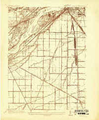 1934 Rossford1934 Print · USGSWood County was a hub of transit and industry in the 1930s, where the Maumee River met a complex web of rail yards and highways. Genealogists can locate family landmarks like Eagle Point Colony, Sunshine Cem, and the old schools at Lark Sch and Glenwood Sch.
 - 1935 Map of Walbridge
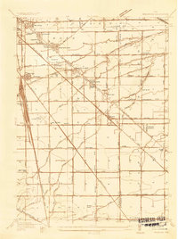 1935 Walbridge1935 Print · USGSThe rail-and-road corridors of Northwest Ohio come alive in this mid-1930s survey of the Walbridge and Millbury area. Genealogists and researchers can pinpoint family landmarks like Hayes Place, the Black Swamp Ch, and early aviation at the Toledo Landing Field.
 - 1938 Map of Walbridge
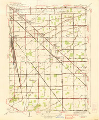 1938 Walbridge1938 Print · USGSNorthwest Ohio at the height of its rail-and-road expansion shows a landscape defined by industrial hubs and developing neighborhoods. Genealogists and historians can trace family locations near Walbridge Yard, Millbury, and rural landmarks like the Allen Cem.2 unique versions available
 - 1938 Map of Rossford
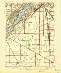 1938 Rossford1938 Print · USGSThe industrial Maumee River valley comes to life in the 1930s, showing a landscape defined by massive rail yards and river islands. Genealogists and local historians can trace the foundations of Eagle Point Colony, the remote Jessie Hill Mission, and old rail hubs like Stanley Yard.
End of results
Showing maps 1-4 of 4
Top cities near Walbridge
- Toledo historical maps
- Bedford Township historical maps
- Bowling Green historical maps
- Perrysburg historical maps
- Oregon historical maps
- Sylvania historical maps
See more
Top neighborhoods of Walbridge
- Deluxe Mobile Home Park historical maps
- Walnut Hills Mobile Home Park historical maps
- Walbridge historical maps
Frequently asked questions
- What are the different types of historical maps available for Walbridge?
- What is the oldest map of Walbridge?
- Where can I purchase historical maps of Walbridge for my home or office?
- Where can I download high-res historical maps of Walbridge?
- Are there historical topographic maps available for Walbridge?
- Is there historical aerial imagery available for Walbridge?
- Where are historical maps of Walbridge sourced from?