1960s Maps of Beaver County, Oklahoma
Explore 3 historic maps of Beaver County from the 1960s. These maps offer a rare glimpse into what life looked like during the 1960s — showing old roads, neighborhoods, homes, and landmarks that have changed or disappeared over time.
Whether you're researching your family's past, planning a metal detecting trip, or studying how Beaver County's landscape evolved across the 1960s, these high-resolution maps are a powerful tool for exploring the history of this region.
- Focus on a specific era: All maps on this page are from the 1960s, giving you a focused view of this time period.
- See what’s changed: Compare century-old streets, trails, and buildings to today's modern landscape using overlays and satellite layers.
- Research with precision: Use these maps for genealogy, historical research, land use analysis, or educational projects.
- View, download, or print: Maps are fully viewable online in high resolution, and can be downloaded or printed for your own records.
Start exploring Beaver County's history through authentic maps from the 1960s. This is your window into the past.
Beaver County, OK maps
(3)- 1962 Map of Irish Flats SE, 1964 Print
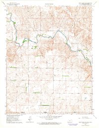 1962 Irish Flats SE1964 Print · USGSThe Kansas-Oklahoma border comes alive in the early sixties, showing the rural landscapes of Meade and Beaver counties. Genealogists and historians can locate the Lutheran Cem and trace the winding path of Crooked Creek near the Odee terrain.
 - 1963 Map of Kismet SE, 1964 Print
 1963 Kismet SE1964 Print · USGSCrossing the Kansas and Oklahoma border in the early sixties, this region preserves the cattle-ranching and energy landscape of the High Plains. Genealogists and historians can trace the footprints of the XI Ranch, the XIT Ranch, and the Friends Ch.2 unique versions available
 - 1963 Map of Irish Flats, 1964 Print
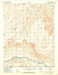 1963 Irish Flats1964 Print · USGSThe Kansas-Oklahoma border comes alive in the early sixties as energy exploration reshapes the plains around Irish Flats. Genealogists and historians can trace the valley of the Cimarron River and find local landmarks like Blair Chapel.2 unique versions available
End of results
Showing maps 1-3 of 3
Top cities of Beaver County
- Beaver historical maps
- Forgan historical maps
- Gate historical maps
- Knowles historical maps
- Slapout historical maps
Frequently asked questions
- What are the different types of historical maps available for Beaver County?
- What is the oldest map of Beaver County?
- Where can I purchase historical maps of Beaver County for my home or office?
- Where can I download high-res historical maps of Beaver County?
- Are there historical topographic maps available for Beaver County?
- Is there historical aerial imagery available for Beaver County?
- Where are historical maps of Beaver County sourced from?