1960s Maps of Beckham County, Oklahoma
Explore 12 historic maps of Beckham County from the 1960s. These maps offer a rare glimpse into what life looked like during the 1960s — showing old roads, neighborhoods, homes, and landmarks that have changed or disappeared over time.
Whether you're researching your family's past, planning a metal detecting trip, or studying how Beckham County's landscape evolved across the 1960s, these high-resolution maps are a powerful tool for exploring the history of this region.
- Focus on a specific era: All maps on this page are from the 1960s, giving you a focused view of this time period.
- See what’s changed: Compare century-old streets, trails, and buildings to today's modern landscape using overlays and satellite layers.
- Research with precision: Use these maps for genealogy, historical research, land use analysis, or educational projects.
- View, download, or print: Maps are fully viewable online in high resolution, and can be downloaded or printed for your own records.
Start exploring Beckham County's history through authentic maps from the 1960s. This is your window into the past.
Beckham County, OK maps
(12)- 1960 Map of Sweetwater, 1961 Print
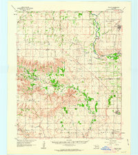
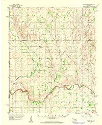 1960 Sweetwater1961 Print · USGSWestern Oklahoma ranching and farming life is detailed in the early sixties as it transitions across the Beckham and Roger Mills county lines. Genealogists can trace family footprints at Sweetwater High Sch and numerous burial sites like Brookside Cem and Mayfield Cem.2 unique versions available
 - 1960 Map of Cheyenne, 1961 Print
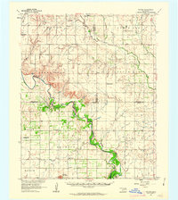
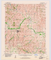 1960 Cheyenne1961 Print · USGSRoger Mills County in the early sixties was a landscape defined by the winding Washita River and the critical corridor of the Panhandle and Santa Fe railroad. Genealogists and local historians can trace the foundations of the area through rural landmarks like Sandstone Sch, the town of Strong City, and the landing field at Cheyenne.3 unique versions available
 - 1960 Map of Sayre, 1961 Print
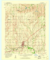 1960 Sayre1961 Print · USGSWestern Oklahoma’s river valleys and rail lines are captured here at the dawn of the 1960s. Genealogists can locate rural landmarks such as Lone Oak Ch, the Sayre-Doxey Cem, and the community of Delhi.2 unique versions available
 - 1960 Map of Hammon, 1961 Print
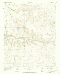
 1960 Hammon1961 Print · USGSHammon and the surrounding High Plains communities are caught here at a mid-century peak of rail and river activity. Local researchers can trace the routes of the Missouri Kansas Texas railroad and locate rural landmarks like Thompson Cem and Moorewood.
 - 1961 Map of Willow, 1963 Print
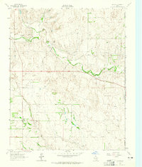
 1961 Willow1963 Print · USGSWestern Oklahoma in the early sixties remains a landscape of rail-connected farming towns and winding river forks. Family historians can trace rural roots through Deer Creek Ch, Carter Cem, and the path of the Missouri Kansas Texas railroad.2 unique versions available
 - 1961 Map of Erick, 1963 Print
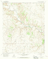
 1961 Erick1963 Print · USGSBeckham County, Oklahoma, sits at the intersection of the Texas border and the great rail lines during the early 1960s. Family historians can trace the community life of Erick and Texola, finding specific landmarks like Munnerson Cem and the local Drive-in Theater.2 unique versions available
 - 1961 Map of Retrop, 1963 Print
 1961 Retrop1963 Print · USGSSouthwestern Oklahoma at the start of the sixties reveals a landscape shaped by river bends and rural oil fields. Genealogists can locate family landmarks like Poarch Cem, Port Sch, and the community of Retrop, all before modern development shifted the countryside.2 unique versions available
 - 1961 Map of Elk City, 1963 Print
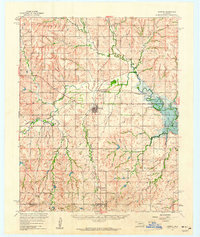
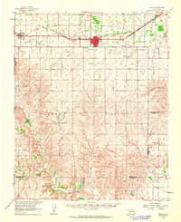
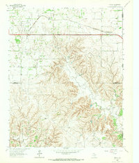
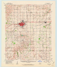 1961 Elk City1963 Print · USGSThe Beckham County plains in the early sixties reveal a landscape shaped by Route 66 and the energy industry. Genealogists and historians can trace rural family sites like Hefner Church, the Ural Cemetery, and local landmarks such as Merritt School.
 - 1962 Map of Kelton SE, 1965 Print
 1962 Kelton SE1965 Print · USGSWheeler County ranchlands and the Oklahoma border are captured here in the early sixties as the petroleum industry began to mark the landscape. Researchers can trace land use through the Oil Wells and Gravel Pits located near the winding North Fork Red River.
 - 1963 Map of Kelton, 1965 Print
 1963 Kelton1965 Print · USGSWheeler County ranchlands and the Oklahoma border come alive in this mid-sixties survey centered on the community of Kelton. Researchers can trace local heritage through landmarks like the Kelton Cem, the Old Rock Sch, and family sites like Britt Ranch.
 - 1963 Map of Fulller, 1967 Print
 1963 Fulller1967 Print · USGSWheeler County and the Oklahoma borderlands are captured here in the early sixties, showing the rail and road network of the High Plains. Researchers can trace the Chicago Rock Island and Pacific railroad through Fuller or locate early energy infrastructure like a regional Pipeline.
 - 1963 Map of Little Wolf Creek, 1967 Print
 1963 Little Wolf Creek1967 Print · USGSThe Texas-Oklahoma borderlands in the early 1960s are defined by high plains drainage and isolated ranching outposts. Genealogists and historians can locate the Needwood Cem, trace the remote Jeep Trail, and find landmarks like Antelope Peak or the Lost Creek Ranch.
End of results
Showing maps 1-12 of 12
Top cities of Beckham County
- Elk City historical maps
- Sayre historical maps
- Erick historical maps
- Carter historical maps
- Texola historical maps
Frequently asked questions
- What are the different types of historical maps available for Beckham County?
- What is the oldest map of Beckham County?
- Where can I purchase historical maps of Beckham County for my home or office?
- Where can I download high-res historical maps of Beckham County?
- Are there historical topographic maps available for Beckham County?
- Is there historical aerial imagery available for Beckham County?
- Where are historical maps of Beckham County sourced from?