1990s Maps of Beckham County, Oklahoma
Explore 2 historic maps of Beckham County from the 1990s. These maps offer a rare glimpse into what life looked like during the 1990s — showing old roads, neighborhoods, homes, and landmarks that have changed or disappeared over time.
Whether you're researching your family's past, planning a metal detecting trip, or studying how Beckham County's landscape evolved across the 1990s, these high-resolution maps are a powerful tool for exploring the history of this region.
- Focus on a specific era: All maps on this page are from the 1990s, giving you a focused view of this time period.
- See what’s changed: Compare century-old streets, trails, and buildings to today's modern landscape using overlays and satellite layers.
- Research with precision: Use these maps for genealogy, historical research, land use analysis, or educational projects.
- View, download, or print: Maps are fully viewable online in high resolution, and can be downloaded or printed for your own records.
Start exploring Beckham County's history through authentic maps from the 1990s. This is your window into the past.
Beckham County, OK maps
(2)- 1990 Map of Foss Reservoir, 1991 Print
 1990 Foss Reservoir1991 Print · USGSWestern Oklahoma’s prairie and river systems are shown here as they appeared in the 1990s, dominated by conservation lands and water management. Researchers can trace the rail paths of the Atchison Topeka and Santa Fe and locate old rural centers like Strong City and Hammon.
 - 1998 Map of Herring, 2001 Print
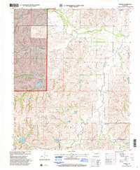 1998 Herring2001 Print · USGSRoger Mills and Beckham counties are captured here in the late nineties as energy extraction shaped the plains. Researchers can locate the Sandstone Sch (Historical), the Sandstone Cem, and the sprawling Kiowa Gas Field.
End of results
Showing maps 1-2 of 2
Top cities of Beckham County
- Elk City historical maps
- Sayre historical maps
- Erick historical maps
- Carter historical maps
- Texola historical maps
Frequently asked questions
- What are the different types of historical maps available for Beckham County?
- What is the oldest map of Beckham County?
- Where can I purchase historical maps of Beckham County for my home or office?
- Where can I download high-res historical maps of Beckham County?
- Are there historical topographic maps available for Beckham County?
- Is there historical aerial imagery available for Beckham County?
- Where are historical maps of Beckham County sourced from?