Old Maps of Bryan County, Oklahoma for Metal Detecting
Plan your next treasure hunt with 168 historic maps of Bryan County. Find old homesites, ghost towns, trails, and gathering spots that may be lost to time — perfect for identifying promising metal detecting locations.
- Locate forgotten sites: Uncover places like long-lost settlements, abandoned rail lines, or gathering spots.
- Plan better hunts: Use map overlays combined with LiDAR or satellite views to narrow in on historically rich areas.
- Made for detectorists: Thousands of hobbyists use these maps to discover relics, coins, and hidden history.
Use these historic maps to boost your research and find new opportunities beneath the surface of Bryan County.
Bryan County, OK maps
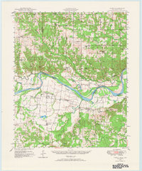
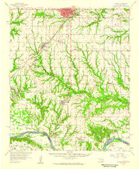
(168)- 1899 Map of Atoka
 1899 Atoka1899 Print · USGSIn the final years of the Indian Territory, this map details the complex border between the Chickasaw and Choctaw Nations. Genealogists can trace early homesteads near Old Boggy Depot, the Buffalo Creek Church, and the Chickasaw Rock Academy.
 - 1900 Map of Atoka
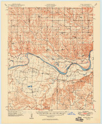
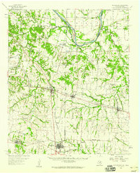
 1900 Atoka1900 Print · USGSIndian Territory at the turn of the century shows the developing rail-and-river network before Oklahoma statehood. Genealogists and historians can trace original settlements like Old Boggy Depot, find the Chickasaw Rock Academy, and follow the Missouri Kansas and Texas R.R. through Atoka.4 unique versions available
 - 1901 Map of Tishomingo
 1901 Tishomingo1901 Print · USGSThe Chickasaw Nation comes to life in this late-frontier survey of Johnston County and the surrounding Indian Territory. Genealogists and historians can locate early industrial sites like the Asphalt Mines, the landmark Harley Institute, and the site of Fort Washita.4 unique versions available
 - 1901 Map of Antlers
 1901 Antlers1901 Print · USGSThe Choctaw Nation territory is captured here during the transitional years before Oklahoma statehood, when the railroad began to reshape the landscape. Genealogists and historians can trace early settlements like Mayhew, the site of Spencer Academy, and the path of the St. Louis and San Francisco line.
 - 1901 Map of Denison
 1901 Denison1901 Print · USGSThe Red River valley in the final years of the Indian Territory era was a landscape of river crossings and rail expansion. Genealogists and historians can trace the early transit networks through Willis Ferry, Cedar Mills, and the Colbert Bridge.4 unique versions available
 - 1903 Map of Paris
 1903 Paris1903 Print · USGSThe Red River borderlands of the Indian Territory and Texas are shown here at the start of the century. Genealogists and researchers can trace early settlements and social hubs like Grant, Oberlin, and the Camp Ground along the winding banks of the Red River.
 - 1912 Map of Antlers
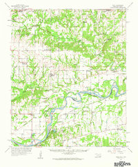
 1912 Antlers1912 Print · USGSSoutheastern Oklahoma’s river valleys and growing rail towns are captured here in the decade following statehood. Genealogists can trace family roots through numerous rural landmarks like Niles Store, the Asphalt Mine, and early school sites such as Timber Hill School.3 unique versions available
 - 1925 Map of Antlers
 1925 Antlers1925 Print · USGSSoutheastern Oklahoma's river valleys and rail lines are documented here in the years following statehood. Genealogists can trace family roots through numerous local landmarks like Armstrong Academy, the Asphalt Mine, and many rural sites like Nelson Chapel School.
 - 1948 Map of Direct, 1968 Print
 1948 Direct1968 Print · USGSThe Red River valley at the close of the 1940s reveals a landscape of isolated farming communities and local schools spanning the Oklahoma-Texas border. Genealogists and historians can trace the foundations of New Oberlin or locate remote landmarks like Iron Stob School and Arch Chapel Cem.
 - 1949 Map of Direct
 1949 Direct1949 Print · USGSThe Oklahoma and Texas borderlands along the Red River are captured here in the late 1940s. Local historians can trace the vanished Oberlin Ferry and old country schools like Crowder Springs School or visit family sites at Forest Grove Cem and Monkstown.2 unique versions available
 - 1950 Map of Mcalester
 1950 Mcalester1950 Print · USGSThe Ouachita Mountains and the coal country of Southeast Oklahoma are shown here in the late 1940s. Genealogists and historians can trace the rail-driven growth of McAlester, Wilburton, and Antlers alongside the rugged terrain of Kiamichi Mountain.2 unique versions available
 - 1953 Map of Texarkana, 1964 Print
 1953 Texarkana1964 Print · USGSThe Texas-Arkansas borderlands are captured here in the mid-fifties, during a decade of massive military and hydraulic engineering projects. Genealogists and researchers can locate family landmarks like Old Boston Cem, Siloam Ch, and the vast Red River Arsenal.4 unique versions available
 - 1954 Map of Sherman, 1964 Print
 1954 Sherman1964 Print · USGSThe Red River valley and North Texas plains are captured here in the mid-fifties, showing the region as new reservoirs like Lake Texoma and Lavon Reservoir reshaped the land. Genealogists can trace family roots through specific local landmarks like Courtney P O, Pilot Grove Sch, and New Hope Ch.2 unique versions available
 - 1956 Map of Texarkana
 1956 Texarkana1956 Print · USGSThe Ark-La-Tex borderlands come alive in the mid-fifties, showing the transition from a rail-dependent rural economy to a post-war industrial landscape. Researchers can trace the massive Red River Ordnance Depot and find towns like Talco, Bogata, and Naples.
 - 1957 Map of Wade, 1959 Print
 1957 Wade1959 Print · USGSThe Red River frontier comes to life in the late fifties as it winds between Oklahoma and Texas. Genealogists can trace family roots at Old Philadelphia Cem, find the INDIAN BOUNDARY, or locate vanished schoolhouses like Beames Sch (Abandoned).
 - 1957 Map of Denison Dam, 1959 Print
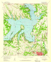
 1957 Denison Dam1959 Print · USGSThe Texas-Oklahoma border comes alive in the late fifties as Denison Dam transforms the Red River valley. Genealogists and local historians can trace family roots through Fairview Cemetery, Layne Sch, and the rail stops of Colbert and Staley.3 unique versions available
 - 1957 Map of Ardmore, 1968 Print
 1957 Ardmore1968 Print · USGSSouth-central Oklahoma in the late fifties was a landscape of rising reservoir waters and expanding rail lines. Genealogists and historians can trace the foundations of Ardmore and Duncan or locate early recreation sites at Platt National Park and Lake Murray State Park.3 unique versions available
 - 1958 Map of Durant, 1959 Print
 1958 Durant1959 Print · USGSSouthern Oklahoma and the Texas borderlands meet along the Red River in the late fifties, showcasing a landscape of rail-fed towns and river crossings. Genealogists can trace family roots through several landmarks like Rose Hill Cem, Lee Chapel, and the historic Old Indian Boundary Line.3 unique versions available
 - 1958 Map of Whitesright, 1959 Print
 1958 Whitesright1959 Print · USGSGrayson and Fannin Counties are captured here in the late fifties, showcasing a landscape of thriving rail-towns and quiet farming communities. Researchers can locate dozens of country burial sites and schools, from Sunnyside Cem to the Bethel Sch.2 unique versions available
 - 1958 Map of Denison Dam, 1959 Print
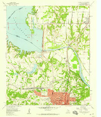
 1958 Denison Dam1959 Print · USGSThe Red River valley was transformed by the late fifties, as the sprawling waters of Lake Texoma redefined the Oklahoma-Texas border. Genealogists and historians can trace the foundations of this lakeside region through sites like Willow Springs Ch, the Old Colbert Bridge, and numerous family cemeteries.2 unique versions available
 - 1958 Map of Sherman, 1959 Print
 1958 Sherman1959 Print · USGSNorth Texas and Southern Oklahoma were undergoing significant development in the late fifties as the Red River Valley transit networks matured. Researchers can trace historic family-named locations such as Saddler Bend, the grounds of Perrin AFB, and early shoreline developments at Lake Texoma.
 - 1962 Map of McAlester
 1962 McAlester1962 Print · USGSSoutheastern Oklahoma and western Arkansas are shown here during the early sixties, a time of transition for the region's mountain communities and timberlands. Researchers can trace the paths of the Kansas City Southern RR through Heavener or locate settlements like Talihina and Broken Bow near the Kiamichi Mountains.2 unique versions available
 - 1963 Map of Ardmore
 1963 Ardmore1963 Print · USGSSouthern Oklahoma during the early sixties shows a landscape defined by the Arbuckle Mountains and a booming energy economy. Genealogists and historians can trace family-named sites across the Ardmore Oil Field, find old schools like Southeastern State College, or locate historic markers such as Boggy Depot State Park.2 unique versions available
 - 1965 Map of McAlester
 1965 McAlester1965 Print · USGSSoutheastern Oklahoma and western Arkansas appear here in the mid-1960s, showing the intersection of the timber industry and the growing reservoir system. Genealogists can trace family roots through settlements like Antlers, Idabel, and Kiowa or follow the historic routes of the Kansas City Southern Ry.3 unique versions available
 - 1967 Map of Little City, 1968 Print
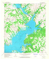 1967 Little City1968 Print · USGSThe northern reaches of Lake Texoma are captured here in the late sixties, where the Washita River was engineered to protect local industry. Researchers can find Fort Washita, the Confederate Cem, and the rerouted Old Channel near Cumberland.
Showing maps 1-25 of 168
Top cities of Bryan County
- Durant historical maps
- Calera historical maps
- Colbert historical maps
- Caddo historical maps
- Bokchito historical maps
- Cartwright historical maps
See more
Frequently asked questions
- What are the different types of historical maps available for Bryan County?
- What is the oldest map of Bryan County?
- Where can I purchase historical maps of Bryan County for my home or office?
- Where can I download high-res historical maps of Bryan County?
- Are there historical topographic maps available for Bryan County?
- Is there historical aerial imagery available for Bryan County?
- Where are historical maps of Bryan County sourced from?