1970s Maps of Canadian County, Oklahoma
Explore 10 historic maps of Canadian County from the 1970s. These maps offer a rare glimpse into what life looked like during the 1970s — showing old roads, neighborhoods, homes, and landmarks that have changed or disappeared over time.
Whether you're researching your family's past, planning a metal detecting trip, or studying how Canadian County's landscape evolved across the 1970s, these high-resolution maps are a powerful tool for exploring the history of this region.
- Focus on a specific era: All maps on this page are from the 1970s, giving you a focused view of this time period.
- See what’s changed: Compare century-old streets, trails, and buildings to today's modern landscape using overlays and satellite layers.
- Research with precision: Use these maps for genealogy, historical research, land use analysis, or educational projects.
- View, download, or print: Maps are fully viewable online in high resolution, and can be downloaded or printed for your own records.
Start exploring Canadian County's history through authentic maps from the 1970s. This is your window into the past.
Canadian County, OK maps
(10)- 1972 Map of El Reno NE, 1974 Print
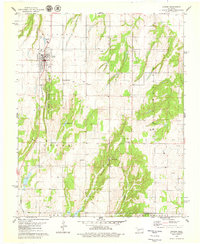
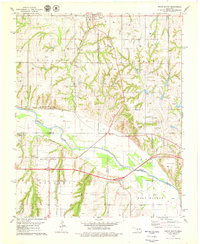
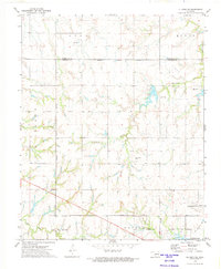 1972 El Reno NE1974 Print · USGSThe Oklahoma prairie comes alive in the early seventies as the municipal boundaries of Piedmont and El Reno begin to stretch across the landscape. Genealogists and local historians can trace family roots at Mathewson Cem and Palmer Cem or locate the Frisco rail line.2 unique versions available
 - 1972 Map of El Reno, 1974 Print
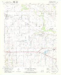
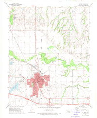 1972 El Reno1974 Print · USGSEl Reno and the surrounding Canadian County plains are captured in the early seventies during a period of steady Midwestern growth. Researchers can trace the legacy of the Indian Treaty Boundary or locate family sites at El Reno Cemetery and the settlement of Concho.2 unique versions available
 - 1972 Map of Okarche, 1974 Print
 1972 Okarche1974 Print · USGSOkarche and the surrounding wheat lands are documented here in the early 1970s at the Kingfisher and Canadian county line. Researchers can trace the Old Indian Treaty Boundary and locate family history sites like Holy Trinity Cem or the Mennonite Ch.
 - 1972 Map of Richland, 1974 Print
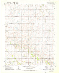
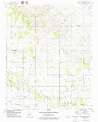
 1972 Richland1974 Print · USGSCanadian County in the early seventies shows the rural landscape of central Oklahoma as city limits began to expand across the prairies. Genealogists and local historians can trace the foundations of Yukon and Richland, locating sites like Frisco Cem and the Chicago Rock Island and Pacific railroad.2 unique versions available
 - 1979 Map of Hinton
 1979 Hinton1979 Print · USGSHinton and the surrounding Caddo County landscape are captured here in the late seventies as the town centered itself around the canyon systems. Researchers can trace ancestral sites at Hinton Cem and Sacred Heart Cem or locate the Old Railroad Grade.
 - 1979 Map of Fort Reno
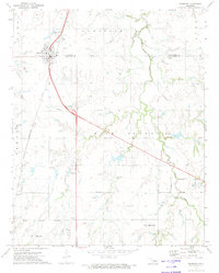
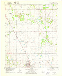
 1979 Fort Reno1979 Print · USGSOklahoma's prairie landscape near the turn of the 1980s reveals a unique mix of military heritage and institutional land use. Researchers can locate the Fort Reno Post Cem, the sprawling El Reno Federal Reformatory, and the tracks of the Chicago Rock Island and Pacific railroad.2 unique versions available
 - 1979 Map of Fort Reno NE
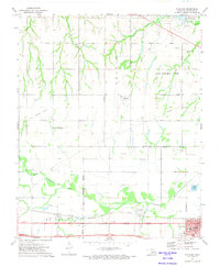
 1979 Fort Reno NE1979 Print · USGSCanadian and Kingfisher counties are captured here in the late seventies, showing a landscape of rural school districts and river bottomlands. Researchers can trace family ties at the Canadian Valley Cem or explore the settlements of Darlington and Altona.
 - 1979 Map of Geary North
 1979 Geary North1979 Print · USGSSettlement in Blaine County and Canadian County during the late 1970s is centered around the rail hub of Geary. Trace the diagonal route of the Chicago Rock Island and Pacific or locate rural landmarks like Grandview Ch and Left Hand Spring.
 - 1979 Map of Geary South
 1979 Geary South1979 Print · USGSThe Canadian River valley in the late seventies reveals a landscape shaped by rail, river, and rural industry. Researchers can trace the Chicago Rock Island and Pacific rail lines, the Old Railroad Grade, and local sites like Graceland Cem and Hinton Junction.2 unique versions available
 - 1979 Map of Porcupine Butte
 1979 Porcupine Butte1979 Print · USGSCanadian County at the end of the seventies shows a busy intersection of Oklahoma energy and agriculture along the river valley. Genealogists and researchers can locate the Swappingback Mission, trace the Chicago Rock Island and Pacific rail line, and find local landmarks like Coleman Chapel.
End of results
Showing maps 1-10 of 10
Top cities of Canadian County
- Yukon historical maps
- Mustang historical maps
- El Reno historical maps
- Piedmont historical maps
- Union City historical maps
- Calumet historical maps
Frequently asked questions
- What are the different types of historical maps available for Canadian County?
- What is the oldest map of Canadian County?
- Where can I purchase historical maps of Canadian County for my home or office?
- Where can I download high-res historical maps of Canadian County?
- Are there historical topographic maps available for Canadian County?
- Is there historical aerial imagery available for Canadian County?
- Where are historical maps of Canadian County sourced from?