1960s Maps of Canadian County, Oklahoma
Explore 13 historic maps of Canadian County from the 1960s. These maps offer a rare glimpse into what life looked like during the 1960s — showing old roads, neighborhoods, homes, and landmarks that have changed or disappeared over time.
Whether you're researching your family's past, planning a metal detecting trip, or studying how Canadian County's landscape evolved across the 1960s, these high-resolution maps are a powerful tool for exploring the history of this region.
- Focus on a specific era: All maps on this page are from the 1960s, giving you a focused view of this time period.
- See what’s changed: Compare century-old streets, trails, and buildings to today's modern landscape using overlays and satellite layers.
- Research with precision: Use these maps for genealogy, historical research, land use analysis, or educational projects.
- View, download, or print: Maps are fully viewable online in high resolution, and can be downloaded or printed for your own records.
Start exploring Canadian County's history through authentic maps from the 1960s. This is your window into the past.
Canadian County, OK maps
(13)- 1963 Map of Oklahoma City
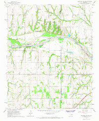
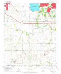
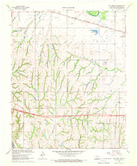
 1963 Oklahoma City1963 Print · USGSCentral Oklahoma in the early sixties showcases a landscape of rapid suburban growth and established oil production. Researchers can trace historic rail lines like the Chicago Rock Island and Pacific RR or locate rural landmarks such as Mayflower School and Bethel Church.
 - 1965 Map of Oklahoma City SW, 1967 Print
 1965 Oklahoma City SW1967 Print · USGSSouthwest of the capital in the mid-sixties, this landscape shows the meeting point of three counties along the Canadian River. Genealogists and historians can trace the early footprints of Tuttle and Newcastle near sites like Snow Hill Ch and Camp Kickapoo.3 unique versions available
 - 1966 Map of Minco NE, 1967 Print
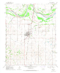
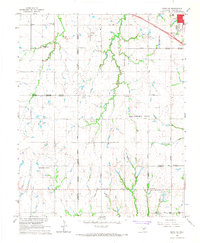 1966 Minco NE1967 Print · USGSCanadian County in the mid-1960s shows the suburban expansion of Oklahoma City meeting established rural communities. Local historians can trace the foundations of Yukon and El Reno or locate sites like Forehand Cem and the Banner Sch.3 unique versions available
 - 1966 Map of Union City, 1967 Print
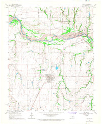
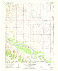
 1966 Union City1967 Print · USGSUnion City and the surrounding Canadian County prairie were defined by the rail and river economy of the mid-sixties. Local researchers can trace the historic footprints of St Josephs church, the Chicago Rock Island and Pacific rail line, and the Mustang Field airstrip.2 unique versions available
 - 1966 Map of Bethany, 1967 Print
 1966 Bethany1967 Print · USGSOklahoma City's western expansion is in full swing during the mid-sixties, showing the transition from oil fields and gravel pits to bustling suburban corridors. Researchers can trace the development of local institutions like Bethany College and St. Francis DeSales Seminary or locate family plots at Chapel Hill Memorial Gardens Cemetery.3 unique versions available
 - 1966 Map of Mustang, 1967 Print
 1966 Mustang1967 Print · USGSThe Oklahoma prairie west of the capital city was rapidly evolving in the mid-sixties as suburban growth pushed into Mustang and Yukon. Genealogists and historians can locate old landmarks like Pleasant Valley Cem, Wheatland, and Mustang Valley Sch along the river basin.3 unique versions available
 - 1966 Map of Minco, 1967 Print
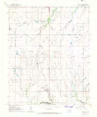
 1966 Minco1967 Print · USGSMinco and the surrounding Grady County prairie are captured here in the mid-1960s, framed by the wide Canadian River. Researchers can trace the Old Oklahoma Indian Territory Boundary Line and locate local landmarks like Evergreen Cem and the rail corridor.2 unique versions available
 - 1966 Map of Piedmont, 1967 Print
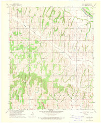
 1966 Piedmont1967 Print · USGSMid-century Piedmont and its surrounding rural townships appear here during a period of urban expansion and petroleum development. Researchers can find old family cemeteries like Kansas Cem, trace the Old Railroad Grade, and locate the early infrastructure of the West Edmond Oil and Gas Field.3 unique versions available
 - 1966 Map of Tuttle, 1967 Print
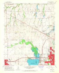
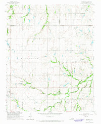
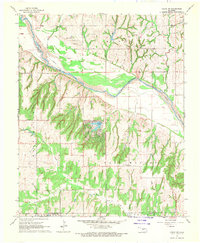
 1966 Tuttle1967 Print · USGSOklahoma's central river valleys were undergoing significant municipal expansion in the 1960s as corporate boundaries shifted. Researchers can trace the rail corridor of the St Louis - San Francisco, locate Riverside Cem, and explore the industrial landscape of Tuttle.3 unique versions available
 - 1967 Map of Fort Reno SW, 1969 Print
 1967 Fort Reno SW1969 Print · USGSCanadian County, Oklahoma, in the late sixties shows a transition from river valley farming to a landscape dotted with the energy industry. Researchers can trace rural school locations like Maple Sch, the Rock Island rail corridor, and local burial sites at Sunny Hill Cem.
 - 1967 Map of Cogar NW, 1970 Print
 1967 Cogar NW1970 Print · USGSThe braided channel of the Canadian River dominates this late-1960s rural landscape on the Caddo and Canadian county line. Genealogists and local historians can trace the foundations of the community at Niles Cem, East Walnut Sch, and Cedar Lake.
 - 1968 Map of Cogar SE, 1969 Print
 1968 Cogar SE1969 Print · USGSCaddo and Grady counties are documented here in the late sixties, showcasing a landscape defined by creek drainages and section-line roads. Researchers can locate rural landmarks such as Hazel Dell Ch, Center View Cem, and the Canadian River bend.
 - 1968 Map of Cogar NE, 1969 Print
 1968 Cogar NE1969 Print · USGSThe Canadian River valley and the rural edges of El Reno and Union City are captured in this late sixties survey. Genealogists can locate Buena Vista Cem, Heaston Ch, and family landmarks across Maple Prairie.2 unique versions available
End of results
Showing maps 1-13 of 13
Top cities of Canadian County
- Yukon historical maps
- Mustang historical maps
- El Reno historical maps
- Piedmont historical maps
- Union City historical maps
- Calumet historical maps
Frequently asked questions
- What are the different types of historical maps available for Canadian County?
- What is the oldest map of Canadian County?
- Where can I purchase historical maps of Canadian County for my home or office?
- Where can I download high-res historical maps of Canadian County?
- Are there historical topographic maps available for Canadian County?
- Is there historical aerial imagery available for Canadian County?
- Where are historical maps of Canadian County sourced from?