1990s Maps of Indiahoma, Oklahoma
Explore 2 historic maps of Indiahoma from the 1990s. These maps offer a rare glimpse into what life looked like during the 1990s — showing old roads, neighborhoods, homes, and landmarks that have changed or disappeared over time.
Whether you're researching your family's past, planning a metal detecting trip, or studying how Indiahoma's landscape evolved across the 1990s, these high-resolution maps are a powerful tool for exploring the history of this region.
- Focus on a specific era: All maps on this page are from the 1990s, giving you a focused view of this time period.
- See what’s changed: Compare century-old streets, trails, and buildings to today's modern landscape using overlays and satellite layers.
- Research with precision: Use these maps for genealogy, historical research, land use analysis, or educational projects.
- View, download, or print: Maps are fully viewable online in high resolution, and can be downloaded or printed for your own records.
Start exploring Indiahoma's history through authentic maps from the 1990s. This is your window into the past.
Indiahoma, OK maps
(2)- 1991 Map of Indiahoma, 1992 Print
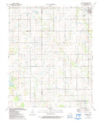 1991 Indiahoma1992 Print · USGSIndiahoma and the surrounding ranchlands at the intersection of three counties are detailed in this early nineties survey. Genealogists can trace family roots at Post Oak Cem, Indiahoma IOOF Cem, and Peace Congregational Ch.
 - 1991 Map of Post Oak Creek, 1992 Print
 1991 Post Oak Creek1992 Print · USGSComanche County during the early nineties reveals a landscape of tribal centers and rural prairie settlements. Trace ancestral roots and local history at the Comanche Tribal Cultural Center, Cache Indian Cem, and the town of Indiahoma.
End of results
Showing maps 1-2 of 2
Top cities near Indiahoma
- Lawton historical maps
- Frederick historical maps
- Cache historical maps
- Snyder historical maps
- Chattanooga historical maps
- Mountain Park historical maps
See more
Frequently asked questions
- What are the different types of historical maps available for Indiahoma?
- What is the oldest map of Indiahoma?
- Where can I purchase historical maps of Indiahoma for my home or office?
- Where can I download high-res historical maps of Indiahoma?
- Are there historical topographic maps available for Indiahoma?
- Is there historical aerial imagery available for Indiahoma?
- Where are historical maps of Indiahoma sourced from?