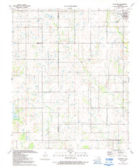
1991 Map of Indiahoma
USGS Topo · Published 1992About this map
The town of Indiahoma sits near the intersection of several county lines in this southwestern Oklahoma survey, including the boundaries of Comanche, Kiowa, and Tillman counties. This agricultural and ranching landscape is defined by its drainages, with Little Oak Creek and Horse Creek winding through the terrain toward the southern reaches near Lake Frederick. Several burial grounds offer significant value for genealogists, including Post Oak Cem, Indiahoma IOOF Cem, and the more isolated Schofield Cem near the southern edge. The area is also home to local landmarks such as Peace Congregational Ch and a small Gravel Pit, illustrating the local industry and community hubs that anchored this corner of the state in the late twentieth century.
Find a feature on this map
19 named features on this map. Tap any name to fly to it.
Don’t see what you’re looking for? This feature index may not catch every label — zoom into the map to look around manually.
Map Details
Editions of this 1991 Indiahoma Map
This is the sole edition of this map. No revisions or reprints were ever made.
Other maps of this area

1937 · Cache
USGS Topo · 1:48,000

1937 · Quanah Mountain
USGS Topo · 1:24,000

1942 · Cache
USGS Topo · 1:62,500

1949 · Quanah Mountain
USGS Topo · 1:24,000

1950 · Snyder
USGS Topo · 1:62,500

1955 · Lawton
USGS Topo · 1:250,000

1956 · Post Oak Creek
USGS Topo · 1:24,000

1956 · Odetta
USGS Topo · 1:24,000
1956 · Quanah Mountain
USGS Topo · 1:24,000

1956 · Manitou
USGS Topo · 1:24,000