1970s Maps of Drumright, Oklahoma
Explore 3 historic maps of Drumright from the 1970s. These maps offer a rare glimpse into what life looked like during the 1970s — showing old roads, neighborhoods, homes, and landmarks that have changed or disappeared over time.
Whether you're researching your family's past, planning a metal detecting trip, or studying how Drumright's landscape evolved across the 1970s, these high-resolution maps are a powerful tool for exploring the history of this region.
- Focus on a specific era: All maps on this page are from the 1970s, giving you a focused view of this time period.
- See what’s changed: Compare century-old streets, trails, and buildings to today's modern landscape using overlays and satellite layers.
- Research with precision: Use these maps for genealogy, historical research, land use analysis, or educational projects.
- View, download, or print: Maps are fully viewable online in high resolution, and can be downloaded or printed for your own records.
Start exploring Drumright's history through authentic maps from the 1970s. This is your window into the past.
Drumright, OK maps
(3)- 1975 Map of Drumright, 1979 Print
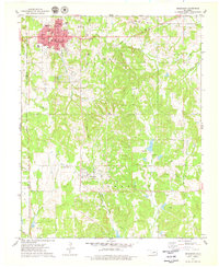 1975 Drumright1979 Print · USGSOklahoma's oil country is captured in the mid-seventies, showing the developed landscapes of the Shannon Oil Field and the grid of Drumright. Genealogists and historians can trace the Indian Territory Oklahoma Boundary and locate the Shamrock Cem or the Old Railroad Grade.
 - 1975 Map of North Village, 1979 Print
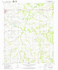 1975 North Village1979 Print · USGSThe Oklahoma oil country east of Cushing comes into focus during the mid-seventies, revealing a landscape of heavy industry and quiet rural settlements. Researchers can trace the legacy of petroleum through several Tank Farms or locate family roots at Silver Star Cem and Harmony Sch.
 - 1978 Map of Oilton, 1979 Print
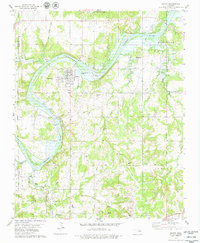 1978 Oilton1979 Print · USGSOilton and the surrounding oil fields are captured here in the late seventies, showing a landscape defined by petroleum production and river geography. Genealogists and local historians can trace family locations near North Highland Cem, the settlement of Pemeta, or the Old Railroad Grade.
End of results
Showing maps 1-3 of 3
Top cities near Drumright
- Cushing historical maps
- Bristow historical maps
- Yale historical maps
- Oilton historical maps
- Depew historical maps
- Jennings historical maps
See more
Frequently asked questions
- What are the different types of historical maps available for Drumright?
- What is the oldest map of Drumright?
- Where can I purchase historical maps of Drumright for my home or office?
- Where can I download high-res historical maps of Drumright?
- Are there historical topographic maps available for Drumright?
- Is there historical aerial imagery available for Drumright?
- Where are historical maps of Drumright sourced from?