1970s Maps of Mounds, Oklahoma
Explore 3 historic maps of Mounds from the 1970s. These maps offer a rare glimpse into what life looked like during the 1970s — showing old roads, neighborhoods, homes, and landmarks that have changed or disappeared over time.
Whether you're researching your family's past, planning a metal detecting trip, or studying how Mounds's landscape evolved across the 1970s, these high-resolution maps are a powerful tool for exploring the history of this region.
- Focus on a specific era: All maps on this page are from the 1970s, giving you a focused view of this time period.
- See what’s changed: Compare century-old streets, trails, and buildings to today's modern landscape using overlays and satellite layers.
- Research with precision: Use these maps for genealogy, historical research, land use analysis, or educational projects.
- View, download, or print: Maps are fully viewable online in high resolution, and can be downloaded or printed for your own records.
Start exploring Mounds's history through authentic maps from the 1970s. This is your window into the past.
Mounds, OK maps
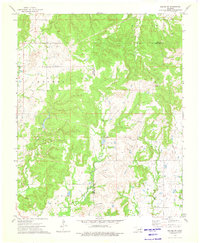
(3)- 1972 Map of Kellyville, 1973 Print
 1972 Kellyville1973 Print · USGSCreek County at the start of the 1970s reveals a landscape defined by petroleum production and mid-century transit corridors. Genealogists and local researchers can locate the Felix Cem, rural sites like Picket Ch, and the extensive oil field surrounding Kellyville.2 unique versions available
 - 1973 Map of Kiefer SW, 1976 Print
 1973 Kiefer SW1976 Print · USGSCreek and Okmulgee Counties are shown in the early seventies during a period of active energy production and rural development. Researchers can trace petroleum history through an extensive Oil Field and landmarks like Osage Hill and the Radio Tower.
 - 1973 Map of Lake Boren, 1976 Print
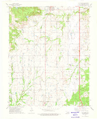 1973 Lake Boren1976 Print · USGSCreek and Okmulgee Counties are shown in the early seventies during a period of active oil and gas extraction. Researchers can locate family sites and rural landmarks like Oakwood Cem, New Bethel Ch, and the tracks of the St Louis-San Francisco railroad.
End of results
Showing maps 1-3 of 3
Top cities near Mounds
- Tulsa historical maps
- Bixby historical maps
- Sapulpa historical maps
- Sand Springs historical maps
- Jenks historical maps
- Glenpool historical maps
See more
Frequently asked questions
- What are the different types of historical maps available for Mounds?
- What is the oldest map of Mounds?
- Where can I purchase historical maps of Mounds for my home or office?
- Where can I download high-res historical maps of Mounds?
- Are there historical topographic maps available for Mounds?
- Is there historical aerial imagery available for Mounds?
- Where are historical maps of Mounds sourced from?