1900s (20th Century) Maps of Enid, Oklahoma
Explore 8 historic maps of Enid from the 1900s (20th Century). These maps offer a rare glimpse into what life looked like during the 1900s — showing old roads, neighborhoods, homes, and landmarks that have changed or disappeared over time.
Whether you're researching your family's past, planning a metal detecting trip, or studying how Enid's landscape evolved across the 1900s, these high-resolution maps are a powerful tool for exploring the history of this region.
- Focus on a specific era: All maps on this page are from the 1900s, giving you a focused view of this time period.
- See what’s changed: Compare century-old streets, trails, and buildings to today's modern landscape using overlays and satellite layers.
- Research with precision: Use these maps for genealogy, historical research, land use analysis, or educational projects.
- View, download, or print: Maps are fully viewable online in high resolution, and can be downloaded or printed for your own records.
Start exploring Enid's history through authentic maps from the 1900s. This is your window into the past.
Enid, OK maps
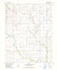
(8)- 1955 Map of Enid West, 1957 Print
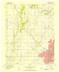 1955 Enid West1957 Print · USGSEnid and the surrounding Garfield County plains are captured here in the mid-fifties during a period of steady civic growth. Researchers can trace the mid-century city grid and its many neighborhood institutions, such as Hoover Sch, Harrison Sch, and the Banner Ch in the nearby countryside.3 unique versions available
 - 1955 Map of Enid East, 1957 Print
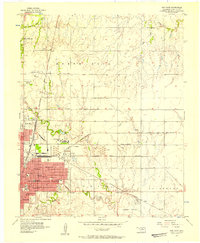 1955 Enid East1957 Print · USGSMid-century Garfield County is revealed as a bustling rail and oil center just as its urban borders began to expand. Genealogists and historians can trace the footprint of Phillips University, the industrial Oil Refinery, and rural landmarks like Pleasant Vale Ch.4 unique versions available
 - 1955 Map of Enid, 1966 Print
 1955 Enid1966 Print · USGSNorth-central Oklahoma's transition from open plains to the blackjack hills of the Osage Indian Reservation is captured in the mid-1950s. Researchers can trace the development of the Naval Reserve Oil Field, the grounds of Vance AFB, and the early footprints of Tulsa and Stillwater.4 unique versions available
 - 1956 Map of Enid, 1957 Print
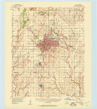 1956 Enid1957 Print · USGSEnid and its surrounding townships thrive in the mid-1950s as a major Oklahoma rail and petroleum hub. Genealogists and historians can trace the foundations of local life at Phillips University, Vance Air Force Base, and rural landmarks like Banner Ch.3 unique versions available
 - 1958 Map of Enid
 1958 Enid1958 Print · USGSNorthern Oklahoma is mapped here in the late fifties, showcasing a dense network of petroleum production and historic tribal lands. Researchers can trace the legacy of the Osage Indian Reservation, early energy hubs like the Cushing Oil Field, and the Chilocco Indian Agricultural School.2 unique versions available
 - 1982 Map of Waukomis, 1983 Print
 1982 Waukomis1983 Print · USGSGarfield County is captured in the early eighties as a hub of military aviation, energy production, and small-town life. Researchers can trace the legacy of Vance Air Force Base, the Oil and Gas Field, and local landmarks like Waukomis Cem.
 - 1982 Map of Enid SE, 1983 Print
 1982 Enid SE1983 Print · USGSGarfield County in the early eighties shows the expansion of Enid into the surrounding agricultural townships. Researchers can find many rural landmarks like Pioneer-Pleasantvale Sch, Bethany Cem, and the extensive Oil And Gas Field along Skeleton Creek.
 - 1990 Map of Enid
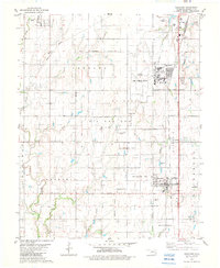
 1990 Enid1990 Print · USGSNorth-central Oklahoma's aviation and energy hubs are captured in the 1990s, from the streets of Stillwater to the runways of Vance Air Force Base. Researchers can locate active Oil and Gas Fields and trace local waterways like Skeleton Creek and Black Bear Creek.
End of results
Showing maps 1-8 of 8
Top cities near Enid
- Waukomis historical maps
- North Enid historical maps
- Lahoma historical maps
- Drummond historical maps
- Kremlin historical maps
- Hunter historical maps
See more
Top neighborhoods of Enid
Frequently asked questions
- What are the different types of historical maps available for Enid?
- What is the oldest map of Enid?
- Where can I purchase historical maps of Enid for my home or office?
- Where can I download high-res historical maps of Enid?
- Are there historical topographic maps available for Enid?
- Is there historical aerial imagery available for Enid?
- Where are historical maps of Enid sourced from?