1970s Maps of Garvin County, Oklahoma
Explore 3 historic maps of Garvin County from the 1970s. These maps offer a rare glimpse into what life looked like during the 1970s — showing old roads, neighborhoods, homes, and landmarks that have changed or disappeared over time.
Whether you're researching your family's past, planning a metal detecting trip, or studying how Garvin County's landscape evolved across the 1970s, these high-resolution maps are a powerful tool for exploring the history of this region.
- Focus on a specific era: All maps on this page are from the 1970s, giving you a focused view of this time period.
- See what’s changed: Compare century-old streets, trails, and buildings to today's modern landscape using overlays and satellite layers.
- Research with precision: Use these maps for genealogy, historical research, land use analysis, or educational projects.
- View, download, or print: Maps are fully viewable online in high resolution, and can be downloaded or printed for your own records.
Start exploring Garvin County's history through authentic maps from the 1970s. This is your window into the past.
Garvin County, OK maps
(3)- 1974 Map of Pernell, 1977 Print
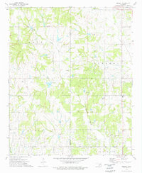 1974 Pernell1977 Print · USGSSouth-central Oklahoma's oil-rich landscapes come into focus during the mid-1970s as industrial development meets rural heritage. Researchers can trace local lineage through Pernell Sch and family landmarks like Robberson Cem and Dripping Springs Cem.
 - 1974 Map of Purdy, 1977 Print
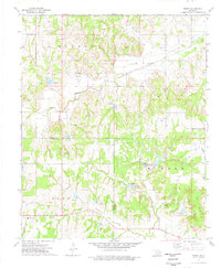 1974 Purdy1977 Print · USGSGarvin and Stephens counties are captured in the mid-1970s, showcasing the intersection of the regional petroleum industry and rural community life. Researchers can locate family landmarks such as Purdy Cem, Doyle Sch, and the Mountain View Ch.
 - 1974 Map of Cox City, 1977 Print
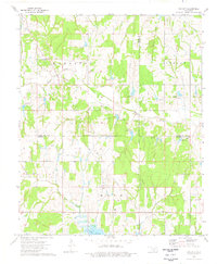 1974 Cox City1977 Print · USGSStephens and Grady counties are shown in the mid-seventies during a height of energy production. Genealogists and historians can trace family roots at Killgore Cem and Pearl Ch, or locate old drilling operations at the Cox City Oil Field.
End of results
Showing maps 1-3 of 3
Top cities of Garvin County
- Pauls Valley historical maps
- Lindsay historical maps
- Wynnewood historical maps
- Stratford historical maps
- Maysville historical maps
- Elmore City historical maps
See more
Frequently asked questions
- What are the different types of historical maps available for Garvin County?
- What is the oldest map of Garvin County?
- Where can I purchase historical maps of Garvin County for my home or office?
- Where can I download high-res historical maps of Garvin County?
- Are there historical topographic maps available for Garvin County?
- Is there historical aerial imagery available for Garvin County?
- Where are historical maps of Garvin County sourced from?