1980s Maps of Waurika, Oklahoma
Explore 4 historic maps of Waurika from the 1980s. These maps offer a rare glimpse into what life looked like during the 1980s — showing old roads, neighborhoods, homes, and landmarks that have changed or disappeared over time.
Whether you're researching your family's past, planning a metal detecting trip, or studying how Waurika's landscape evolved across the 1980s, these high-resolution maps are a powerful tool for exploring the history of this region.
- Focus on a specific era: All maps on this page are from the 1980s, giving you a focused view of this time period.
- See what’s changed: Compare century-old streets, trails, and buildings to today's modern landscape using overlays and satellite layers.
- Research with precision: Use these maps for genealogy, historical research, land use analysis, or educational projects.
- View, download, or print: Maps are fully viewable online in high resolution, and can be downloaded or printed for your own records.
Start exploring Waurika's history through authentic maps from the 1980s. This is your window into the past.
Waurika, OK maps
(4)- 1984 Map of Waurika West, 1985 Print
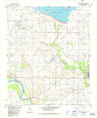 1984 Waurika West1985 Print · USGSJefferson County was undergoing significant water and transit changes in the mid-1980s as Waurika Lake took its modern shape. Researchers can trace the Old Railroad Grade and find local landmarks like Moneka Park and the original grid of Hastings.
 - 1985 Map of Burkburnett, 1986 Print
 1985 Burkburnett1986 Print · USGSThe Red River valley and North Texas oil fields are captured here in the mid-eighties, showing the vital connection between military hubs and rail towns. Researchers can trace the path of the Missouri Kansas Texas railroad through Burkburnett or locate Waurika Lake and Sheppard Air Force Base.2 unique versions available
 - 1986 Map of Ardmore
 1986 Ardmore1986 Print · USGSSouthern Oklahoma in the mid-eighties was a landscape of rugged geology and deep petroleum roots. Genealogists and historians can trace the development of Ardmore and Healdon alongside the vast Sholem Alechem Oil Field and the rails of the AT & SF RR.2 unique versions available
 - 1987 Map of Waurika East, 1988 Print
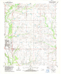 1987 Waurika East1988 Print · USGSJefferson County ranchlands and town centers are shown here in the late 1980s, just as the regional rail network was evolving. Researchers can trace the Indian Territory Boundary Line, find the Historical Museum in Waurika, and locate local landmarks like Monument Hill and Addington.
End of results
Showing maps 1-4 of 4
Top cities near Waurika
- Comanche historical maps
- Temple historical maps
- Ryan historical maps
- Empire City historical maps
- Petrolia historical maps
- Byers historical maps
See more
Frequently asked questions
- What are the different types of historical maps available for Waurika?
- What is the oldest map of Waurika?
- Where can I purchase historical maps of Waurika for my home or office?
- Where can I download high-res historical maps of Waurika?
- Are there historical topographic maps available for Waurika?
- Is there historical aerial imagery available for Waurika?
- Where are historical maps of Waurika sourced from?