1970s Maps of Guthrie, Oklahoma
Explore 6 historic maps of Guthrie from the 1970s. These maps offer a rare glimpse into what life looked like during the 1970s — showing old roads, neighborhoods, homes, and landmarks that have changed or disappeared over time.
Whether you're researching your family's past, planning a metal detecting trip, or studying how Guthrie's landscape evolved across the 1970s, these high-resolution maps are a powerful tool for exploring the history of this region.
- Focus on a specific era: All maps on this page are from the 1970s, giving you a focused view of this time period.
- See what’s changed: Compare century-old streets, trails, and buildings to today's modern landscape using overlays and satellite layers.
- Research with precision: Use these maps for genealogy, historical research, land use analysis, or educational projects.
- View, download, or print: Maps are fully viewable online in high resolution, and can be downloaded or printed for your own records.
Start exploring Guthrie's history through authentic maps from the 1970s. This is your window into the past.
Guthrie, OK maps
(6)- 1970 Map of Navina, 1971 Print
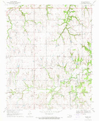 1970 Navina1971 Print · USGSLogan County farmland and the community of Navina are captured here in 1970, showing the region as its rail-dependent past gave way to modern utility corridors. Researchers can trace the path of an Old Railroad Grade and locate local landmarks like Harmony Cem and Iron Mound.2 unique versions available
 - 1970 Map of Guthrie North, 1972 Print
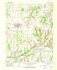
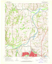 1970 Guthrie North1972 Print · USGSNorth of Guthrie in the early 1970s, the river valley landscape is shaped by the sweeping Cimarron River and its rail corridors. Researchers can locate family landmarks like Summit View Cemetery, the Masonic Temple, and small settlements at Lawrie and Camp Joy.3 unique versions available
 - 1970 Map of Guthrie South, 1972 Print
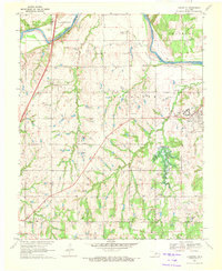
 1970 Guthrie South1972 Print · USGSLogan County, Oklahoma, comes into focus in the early seventies as the area around Guthrie balances its oil production and aviation growth. Researchers can trace family history through Seward Cem, find the old Faubion Sch, or follow the old RR grade.3 unique versions available
 - 1970 Map of Langston, 1972 Print
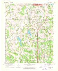
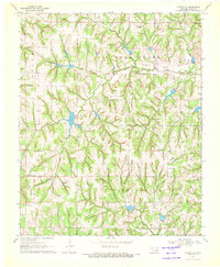
 1970 Langston1972 Print · USGSThe Oklahoma countryside near the Logan and Payne county line is captured here just as the landscape was being reshaped by the Langston Dam Under Constr. Researchers can locate Langston University, several family-named community halls, and numerous cemeteries like Mt Hope Cem and Holy Family Cem.3 unique versions available
 - 1970 Map of Crescent, 1972 Print
 1970 Crescent1972 Print · USGSCrescent and the Cimarron River valley are shown here at the height of the 1970s oil boom. Local historians can trace the industrial footprint of the East Lovell Oil Field and the Atchison Topeka and Santa Fe railroad alongside historic sites like Knowles Cem.2 unique versions available
 - 1970 Map of Guthrie SE, 1972 Print
 1970 Guthrie SE1972 Print · USGSLogan County oil production and rural life meet in this early 1970s study of the Oklahoma landscape. Researchers can trace family sites at Oak Ridge Cemetery or locate industrial landmarks like the Northwest Evansville Oil Field.
End of results
Showing maps 1-6 of 6
Top cities near Guthrie
- Oklahoma City historical maps
- Edmond historical maps
- Piedmont historical maps
- Jones historical maps
- Langston historical maps
- Crescent historical maps
See more
Top neighborhoods of Guthrie
Frequently asked questions
- What are the different types of historical maps available for Guthrie?
- What is the oldest map of Guthrie?
- Where can I purchase historical maps of Guthrie for my home or office?
- Where can I download high-res historical maps of Guthrie?
- Are there historical topographic maps available for Guthrie?
- Is there historical aerial imagery available for Guthrie?
- Where are historical maps of Guthrie sourced from?