1950s Maps of Broken Bow, Oklahoma
Explore 9 historic maps of Broken Bow from the 1950s. These maps offer a rare glimpse into what life looked like during the 1950s — showing old roads, neighborhoods, homes, and landmarks that have changed or disappeared over time.
Whether you're researching your family's past, planning a metal detecting trip, or studying how Broken Bow's landscape evolved across the 1950s, these high-resolution maps are a powerful tool for exploring the history of this region.
- Focus on a specific era: All maps on this page are from the 1950s, giving you a focused view of this time period.
- See what’s changed: Compare century-old streets, trails, and buildings to today's modern landscape using overlays and satellite layers.
- Research with precision: Use these maps for genealogy, historical research, land use analysis, or educational projects.
- View, download, or print: Maps are fully viewable online in high resolution, and can be downloaded or printed for your own records.
Start exploring Broken Bow's history through authentic maps from the 1950s. This is your window into the past.
Broken Bow, OK maps
(9)- 1950 Map of Mcalester
 1950 Mcalester1950 Print · USGSThe Ouachita Mountains and the coal country of Southeast Oklahoma are shown here in the late 1940s. Genealogists and historians can trace the rail-driven growth of McAlester, Wilburton, and Antlers alongside the rugged terrain of Kiamichi Mountain.2 unique versions available
 - 1950 Map of Idabel, 1962 Print
 1950 Idabel1962 Print · USGSSoutheastern Oklahoma’s river valleys and rail corridors are captured here just after the war, centered on the growing community of Idabel. Researchers can trace the lineage of local families through landmarks like Gray High Sch, Denison Cem, and rural outposts such as Twin Springs.3 unique versions available
 - 1950 Map of Shults, 1975 Print
 1950 Shults1975 Print · USGSMcCurtain County is documented in the mid-twentieth century as a landscape of river bends and rural settlements. Researchers can trace family history at the Redland Cem or locate community centers like Douglas Chapel and Shults.2 unique versions available
 - 1951 Map of Idabel
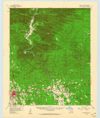
 1951 Idabel1951 Print · USGSMcCurtain County enters the 1950s with its seat of Idabel as a bustling rail and civic hub. Genealogists and local historians can trace the foundations of the community through its many local schools and churches like Gray High Sch and Livingland Ch.2 unique versions available
 - 1951 Map of Shults
 1951 Shults1951 Print · USGSMcCurtain County's riverbottoms and rural uplands are shown here just after the war, centered on the winding Little River. Genealogists and local historians can trace family locations near Shults, the Redland Cem, and old country landmarks like Welch Store.2 unique versions available
 - 1953 Map of Texarkana, 1964 Print
 1953 Texarkana1964 Print · USGSThe Texas-Arkansas borderlands are captured here in the mid-fifties, during a decade of massive military and hydraulic engineering projects. Genealogists and researchers can locate family landmarks like Old Boston Cem, Siloam Ch, and the vast Red River Arsenal.4 unique versions available
 - 1956 Map of Texarkana
 1956 Texarkana1956 Print · USGSThe Ark-La-Tex borderlands come alive in the mid-fifties, showing the transition from a rail-dependent rural economy to a post-war industrial landscape. Researchers can trace the massive Red River Ordnance Depot and find towns like Talco, Bogata, and Naples.
 - 1959 Map of Golden, 1960 Print
 1959 Golden1960 Print · USGSMcCurtain County's timberlands and river bottoms are shown in detail during the late fifties, featuring the winding Glover River and the local Industrial Railroad. Genealogists and historians can locate rural landmarks like Lukfata Cem, Nebiah Chito Ch, and the settlement of Golden.2 unique versions available
 - 1959 Map of Broken Bow, 1960 Print
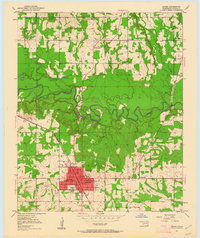
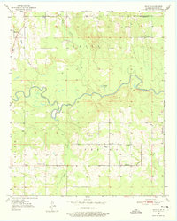
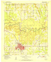
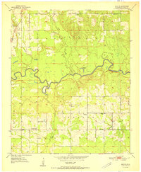
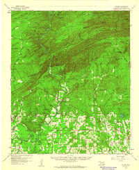
 1959 Broken Bow1960 Print · USGSSoutheastern Oklahoma's timberlands and river valleys are captured here in the late fifties, just as the region's wilderness character met growing infrastructure. Genealogists can locate family landmarks such as Goodwater Ch, Eagletown, and the original site of Hochatown along the Mountain Fork River.3 unique versions available
End of results
Showing maps 1-9 of 9
Top cities near Broken Bow
Frequently asked questions
- What are the different types of historical maps available for Broken Bow?
- What is the oldest map of Broken Bow?
- Where can I purchase historical maps of Broken Bow for my home or office?
- Where can I download high-res historical maps of Broken Bow?
- Are there historical topographic maps available for Broken Bow?
- Is there historical aerial imagery available for Broken Bow?
- Where are historical maps of Broken Bow sourced from?