1940s Maps of Muskogee County, Oklahoma
Explore 5 historic maps of Muskogee County from the 1940s. These maps offer a rare glimpse into what life looked like during the 1940s — showing old roads, neighborhoods, homes, and landmarks that have changed or disappeared over time.
Whether you're researching your family's past, planning a metal detecting trip, or studying how Muskogee County's landscape evolved across the 1940s, these high-resolution maps are a powerful tool for exploring the history of this region.
- Focus on a specific era: All maps on this page are from the 1940s, giving you a focused view of this time period.
- See what’s changed: Compare century-old streets, trails, and buildings to today's modern landscape using overlays and satellite layers.
- Research with precision: Use these maps for genealogy, historical research, land use analysis, or educational projects.
- View, download, or print: Maps are fully viewable online in high resolution, and can be downloaded or printed for your own records.
Start exploring Muskogee County's history through authentic maps from the 1940s. This is your window into the past.
Muskogee County, OK maps
(5)- 1946 Map of Fort Smith
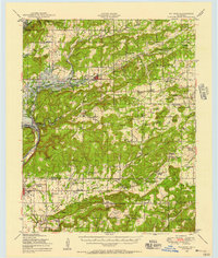
 1946 Fort Smith1946 Print · USGSThe Arkansas-Oklahoma borderlands appear here in the mid-forties, as new reservoirs began to transform the river valleys. Genealogists and historians can trace rail-served towns from Muskogee to Fort Smith and locate landmarks like Camp Chaffee.
 - 1948 Map of Hulbert, 1957 Print
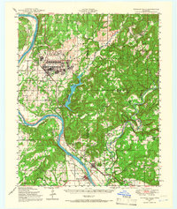
 1948 Hulbert1957 Print · USGSCherokee County at mid-century reveals a landscape of rural schoolhouses and family cemeteries just as the reservoir began to reshape the river valley. Genealogists can trace family roots through sites like Sequoyah Indian Sch, Lost City, and the Fort Gibson National Cem.3 unique versions available
 - 1948 Map of Keefeton, 1963 Print
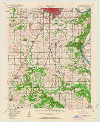 1948 Keefeton1963 Print · USGSMuskogee County in the late 1940s is a hub of overlapping rail lines and small rural communities just before the major shifts of the postwar era. Researchers can trace the heritage of local settlements like Rentiesville and Summit or locate family burial sites at Brushy Mtn Cem and McLain Cem.2 unique versions available
 - 1948 Map of Webbers Falls, 1966 Print
 1948 Webbers Falls1966 Print · USGSThe Arkansas River valley at the close of the 1940s reveals a mix of wartime military expansion and traditional river settlements. Genealogists can locate family-named landmarks and rural institutions like South Bethel Cem, Howard Chapel, and Liberty Sch.2 unique versions available
 - 1948 Map of Wagoner, 1967 Print
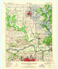 1948 Wagoner1967 Print · USGSThe river-confluence region of eastern Oklahoma is seen here just after the war, as the Fort Gibson Reservoir begins to take shape. Researchers can trace numerous rural landmarks like the Mulrow Ind Orphans Home, Tullahassee, and Blue Mound Cem.
End of results
Showing maps 1-5 of 5
Top cities of Muskogee County
- Muskogee historical maps
- Haskell historical maps
- Warner historical maps
- Porum historical maps
- Webbers Falls historical maps
- Taft historical maps
See more
Frequently asked questions
- What are the different types of historical maps available for Muskogee County?
- What is the oldest map of Muskogee County?
- Where can I purchase historical maps of Muskogee County for my home or office?
- Where can I download high-res historical maps of Muskogee County?
- Are there historical topographic maps available for Muskogee County?
- Is there historical aerial imagery available for Muskogee County?
- Where are historical maps of Muskogee County sourced from?