1990s Maps of Forest Park, Oklahoma
Explore 3 historic maps of Forest Park from the 1990s. These maps offer a rare glimpse into what life looked like during the 1990s — showing old roads, neighborhoods, homes, and landmarks that have changed or disappeared over time.
Whether you're researching your family's past, planning a metal detecting trip, or studying how Forest Park's landscape evolved across the 1990s, these high-resolution maps are a powerful tool for exploring the history of this region.
- Focus on a specific era: All maps on this page are from the 1990s, giving you a focused view of this time period.
- See what’s changed: Compare century-old streets, trails, and buildings to today's modern landscape using overlays and satellite layers.
- Research with precision: Use these maps for genealogy, historical research, land use analysis, or educational projects.
- View, download, or print: Maps are fully viewable online in high resolution, and can be downloaded or printed for your own records.
Start exploring Forest Park's history through authentic maps from the 1990s. This is your window into the past.
Forest Park, OK maps
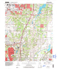
(3)- 1990 Map of Oklahoma City North
 1990 Oklahoma City North1990 Print · USGSOklahoma City and its northern reaches are captured in the 1990s as suburban growth stretched toward the Cimarron River. Genealogists and historians can trace rail-town legacies along the Atchison Topeka and Santa Fe Railroad and find landmarks like the El Reno Federal Reformatory.
 - 1995 Map of Spencer, 1999 Print
 1995 Spencer1999 Print · USGSThe northeast suburbs of Oklahoma City appear in the mid-nineties as a mix of growing residential districts and established institutions. Genealogists and local historians can trace family locations near Hebrew Cem, Piper Cem, and the historic Lone Star Ch.
 - 1995 Map of Midwest City, 2000 Print
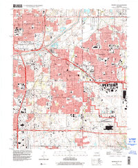 1995 Midwest City2000 Print · USGSMid-century urban expansion and military infrastructure define this Oklahoma County landscape in the mid-nineties. Researchers can locate family landmarks like Sunnylane Cemetery, the sprawling Tinker Air Force Base, and schools like Douglass High Sch.
End of results
Showing maps 1-3 of 3
Top cities near Forest Park
- Oklahoma City historical maps
- Norman historical maps
- Edmond historical maps
- Midwest City historical maps
- Moore historical maps
- Del City historical maps
See more
Top neighborhoods of Forest Park
Frequently asked questions
- What are the different types of historical maps available for Forest Park?
- What is the oldest map of Forest Park?
- Where can I purchase historical maps of Forest Park for my home or office?
- Where can I download high-res historical maps of Forest Park?
- Are there historical topographic maps available for Forest Park?
- Is there historical aerial imagery available for Forest Park?
- Where are historical maps of Forest Park sourced from?